PaulAnn, San Angelo
Updated · 5,718 residents
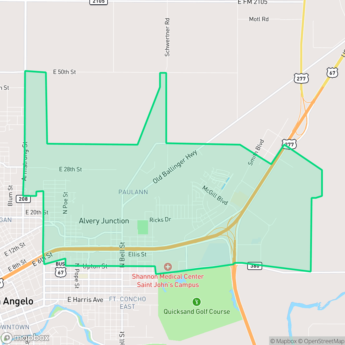
PaulAnn is a quiet, rural-industrial fringe neighborhood in San Angelo defined by its mix of residential pockets and light industrial facilities. The area offers a low-density environment with significant open space, though residents rely on personal vehicles for daily errands due to limited walkability.
Key Highlights
About PaulAnn
The PaulAnn neighborhood in San Angelo, Texas, originated in 1987 when developers Paul and Ann Gregory established the PaulAnn subdivision along a major highway entering the city. As part of their development, the Gregories donated ten acres of land for the construction of two neighboring churches. One of these parcels became the home of PaulAnn Baptist Church, which moved to the site in 1987 and has since expanded into a prominent local landmark. The residential landscape of PaulAnn features a mix of single-family homes and mobile homes, with much of its housing stock built between 1970 and 1999, alongside newer constructions from the 2000s. Today, the neighborhood maintains a quiet, community-oriented character with local spaces like PaulAnn Park.
The area is characterized by vast open scrubland and low-density development, creating a remote atmosphere on the outskirts of the city. It serves as a transition zone with a blend of residential clusters, large-scale commercial storage, and logistics infrastructure. The landscape is dominated by warehouses, freight corridors, and active rail lines, which contribute to a distinct industrial character. While the area features quiet streets and accessible green spaces like PaulAnn Park, the proximity to major highways and logistics hubs defines the daily experience for residents.
Living here requires a car, as the lack of local commercial density makes walking to essential services difficult. The neighborhood is best suited for those who prioritize a quiet, low-density setting over urban convenience. Prospective residents should note the industrial presence, which includes active rail sidings and trucking yards, and consider the school district options, as the area is served by both the highly-rated Veribest Independent School District and the San Angelo Independent School District.
Neighborhood Scores Across 15 Qualities
Residential plots offer a mix of spacing and buffer zones between properties, providing a level of privacy that is roughly equal to the San Angelo average.
Low traffic and quiet streets provide a calm environment for walking, though the lack of sidewalks makes it slightly less walkable than the San Angelo average.
Standard tract housing with modest yards and uniform rooflines defines the landscape. According to iHuus data, the area offers less visual variety than the San Angelo average.
Access to public parks and wide green verges is sparse in this area. According to iHuus data, opportunities for dog walking are below the San Angelo average.
Large agricultural fields, industrial yards, and open scrubland characterize this area. This landscape features more open space and less density than the typical San Angelo neighborhood, according to iHuus data.
Low activity levels and a lack of commercial density create a tranquil, car-dependent environment. This area is less lively than the San Angelo average, characterized primarily by residential pockets and light industrial zones with limited local destinations.
Local traffic from nearby busy streets creates a steady background hum. This level of activity is slightly higher than the average for San Angelo, according to iHuus data.
Low industrial presence defines this area, which features mostly residential streets and occasional light commercial activity. According to iHuus data, the neighborhood experiences less industrial proximity than the San Angelo average.
Health insurance accessibility is lower in this area than in the rest of San Angelo. According to iHuus data, a minority of the resident population possesses health coverage.
Conservative values are predominant in this area, with a slightly more pronounced conservative majority than the San Angelo average according to iHuus data.
Residents live alongside a balanced mix of young adults, families, and older individuals. This demographic spread is largely consistent with the overall age distribution found across San Angelo.
Flood risk in this area is significantly higher than the San Angelo average. Residents should expect elevated or potentially prohibitive flood insurance costs due to the neighborhood's vulnerability to water hazards.
Address-Level Insights for PaulAnn


iHuus Neighborhood Intelligence Insights
Get address-level neighborhood insights for PaulAnn
- Street-level scores — see how individual blocks compare, not just neighborhood averages
- Micro-zone boundaries — identify quiet pockets, flood boundaries, and walkable clusters before you visit
- 15 dimensions in full — walkability, noise, air quality, school quality, insurance coverage, population age profile, urban/rural index, and more
- Boundary risk alerts — know if your address sits near a block boundary where scores drop, the kind of detail no listing will ever mention
- School insights — individual school ratings and insights, not just district-level data
- Compare before you commit — side-by-side data across neighborhoods, down to block precision
No credit card required
Compare with Any Neighborhood
| Dimension | PaulAnn | Angelo Heights |
|---|---|---|
| 🚶 Walkabilityavg 5.86 | ||
| 🔊 Acoustic Comfortavg 4.52 | ||
| 🤫 Privacy Indexavg 6.06 | ||
| 🎨 Visual Appealavg 5.61 | ||
| 🐕 Dog Friendlinessavg 5.82 | ||
| 🗺️ Urban-Rural Indexavg 7.3 | ||
| ✨ Neighborhood Vibeavg 4.15 | ||
| 🏥 Health Insurance Coverageavg 6.22 | ||
| 🌿 Air Quality | ||
| 🏭 Industrial Proximityavg 8.42 | ||
| 🌊 Flood Safetyavg 3.02 | ||
| 🗳️ Ideological Leanavg 1.23 | ||
| 👥 Population Age Profileavg 4.73 | ||
| 🔥 Fire Safety | ||
| 🏫 School Quality |
PaulAnn Rankings
School Districts Serving PaulAnn
School Insights for PaulAnn
Below average outcomes; significant attendance and academic challenges.
School Insights
See what's really behind every school rating near PaulAnn
- Individual school ratings — each school's own score with outcome context, not just a district average
- Enrollment & class size data — student-to-teacher ratio and how it compares to the state average
- Full demographics breakdown — ethnicity and gender composition for every school in the enrollment zone
- Every school in the district — all schools within the enrollment boundary ranked by rating, not just the closest one
- Grade levels & benchmarks — elementary through high school, with below/above state-average flags
No credit card required