Fort Concho, San Angelo
Updated · 2,755 residents
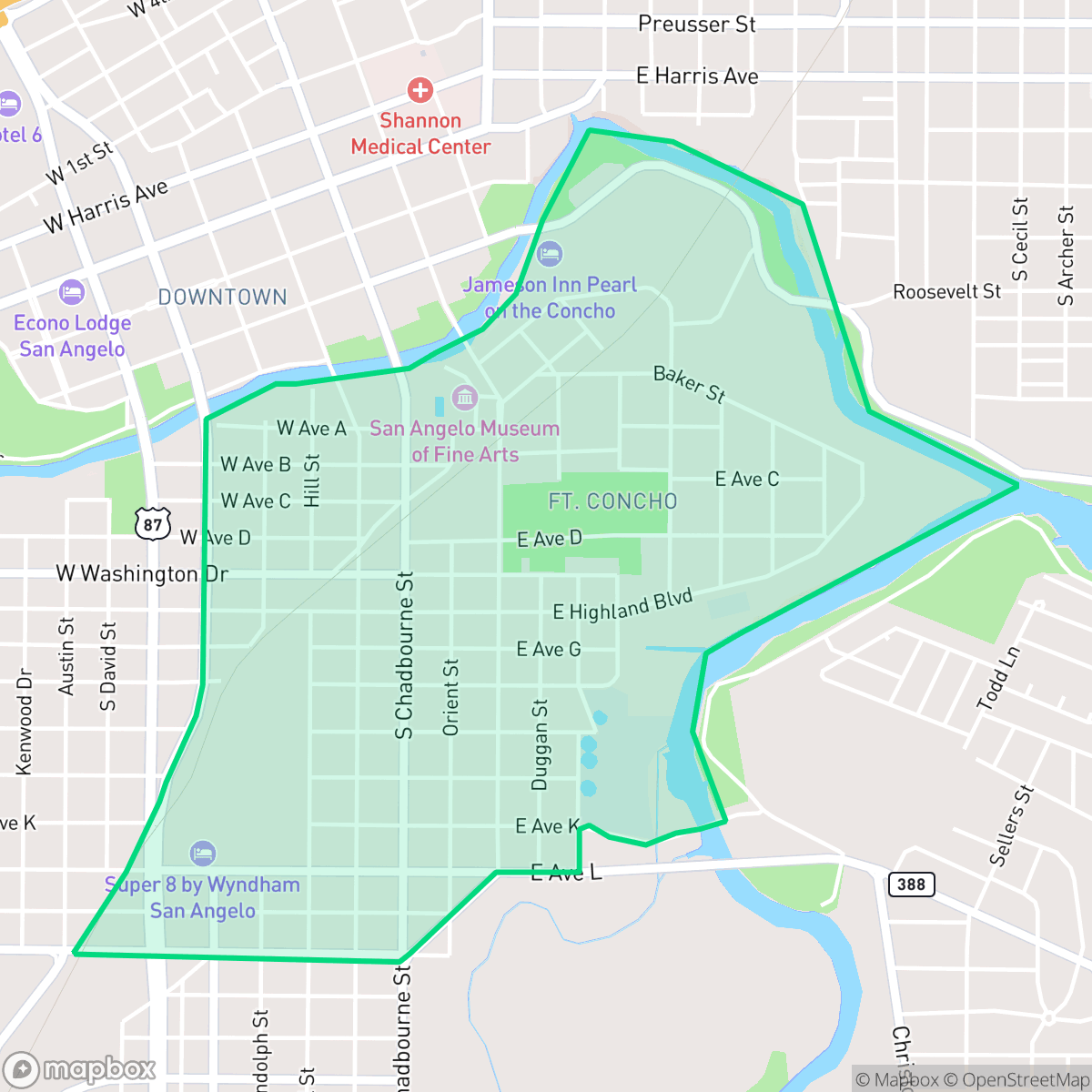
Fort Concho is defined by its namesake landmark and a distinct mix of residential blocks, light industrial units, and open municipal spaces. While the area offers unique cultural access and a lively local dining scene, residents should expect a car-dependent environment with moderate noise levels from nearby road traffic. According to iHuus data, the neighborhood provides a balanced suburban feel, though it remains closely integrated with active industrial infrastructure.
Key Highlights
About Fort Concho
The Fort Concho neighborhood in San Angelo originated with the establishment of the Fort Concho military post in November 1867. Built primarily of native limestone, the fort served as a vital frontier outpost and regimental headquarters for the famous African American "Buffalo Soldiers" of the 10th Cavalry. After the military abandoned the post in June 1889, the surrounding area underwent a major transformation. In 1905, developer C. A. Broome established the Fort Concho Realty Company, subdividing the land into residential and commercial lots. While many of the historic limestone structures were initially repurposed as private homes or businesses, dedicated preservation efforts starting in the early 20th century successfully restored much of the original post. Today, the neighborhood is anchored by the Fort Concho National Historic Landmark, which preserves 24 original and restored frontier-era buildings.
The neighborhood functions as a blend of historic preservation and modern utility, characterized by a low-density grid that integrates residential streets with commercial warehouses and green spaces. Local social hubs, such as the Railway Museum of San Angelo and various neighborhood eateries, contribute to a higher-than-average livability score for the city. The area maintains a consistent pace of life, supported by a mix of modest housing and community landmarks that draw visitors and locals alike.
Prospective residents should weigh the unique cultural amenities against the practical realities of the area. The neighborhood is primarily car-dependent, and the presence of industrial infrastructure, including a nearby wastewater treatment facility, influences the overall environment. While the San Angelo Independent School District faces challenges with district-wide consolidation, the local elementary school is highly regarded. According to iHuus data, the area is suited for those who prioritize proximity to historical landmarks and a suburban-industrial lifestyle over high-density walkability or absolute silence.
Neighborhood Scores Across 15 Qualities
Residents can expect a moderate level of separation between properties with a mix of building densities. According to iHuus data, this degree of privacy is roughly in line with the average across San Angelo.
Low traffic volume makes for a calm walking environment, though the lack of sidewalks makes it slightly less pedestrian-friendly than much of San Angelo.
Residential scenery consists of typical tract housing with modest yards and simple rooflines. This level of visual variety is roughly in line with the San Angelo city average, according to iHuus data.
Direct access to public parks and wide green verges make pet walking convenient. According to iHuus data, this area offers slightly better amenities for dogs than the San Angelo average.
Frequent open land and agricultural spaces provide a more spacious feel than the typical San Angelo urban layout. According to iHuus data, this area features a low-density mix of residential blocks and undeveloped riverfront properties.
Diverse dining options and social hubs provide more activity than the San Angelo average, though the layout remains largely car-dependent. According to iHuus data, the area features a blend of suburban green spaces and scattered commercial amenities near historic landmarks.
Steady traffic sounds from nearby busy streets are present, though the level of acoustic activity is slightly higher than the San Angelo average.
Light industrial facilities and a wastewater treatment plant are situated near residential zones, making the area more industrial than the San Angelo average. This mix of utility infrastructure and residential streets creates a landscape of varied land use, according to iHuus data.
Health insurance accessibility is lower than the San Angelo average. According to iHuus data, a minority of residents in this area possess active health coverage.
Conservative residents make up the majority of the population, representing a more conservative leaning than the San Angelo average according to iHuus data.
Residents will find a balanced mix of young adults, families, and older individuals; according to iHuus data, this demographic variety is slightly more diverse than the San Angelo average.
Flood risk in this area is higher than the San Angelo average, though official FEMA assessments for this specific location remain incomplete. Residents should exercise caution as the precise level of flood vulnerability is currently undetermined.
Address-Level Insights for Fort Concho


iHuus Neighborhood Intelligence Insights
Get address-level neighborhood insights for Fort Concho
- Street-level scores — see how individual blocks compare, not just neighborhood averages
- Micro-zone boundaries — identify quiet pockets, flood boundaries, and walkable clusters before you visit
- 15 dimensions in full — walkability, noise, air quality, school quality, insurance coverage, population age profile, urban/rural index, and more
- Boundary risk alerts — know if your address sits near a block boundary where scores drop, the kind of detail no listing will ever mention
- School insights — individual school ratings and insights, not just district-level data
- Compare before you commit — side-by-side data across neighborhoods, down to block precision
No credit card required
Compare with Any Neighborhood
| Dimension | Fort Concho | Angelo Heights |
|---|---|---|
| 🚶 Walkabilityavg 5.86 | ||
| 🔊 Acoustic Comfortavg 4.52 | ||
| 🤫 Privacy Indexavg 6.06 | ||
| 🎨 Visual Appealavg 5.61 | ||
| 🐕 Dog Friendlinessavg 5.82 | ||
| 🗺️ Urban-Rural Indexavg 7.3 | ||
| ✨ Neighborhood Vibeavg 4.15 | ||
| 🏥 Health Insurance Coverageavg 6.22 | ||
| 🌿 Air Quality | ||
| 🏭 Industrial Proximityavg 8.42 | ||
| 🌊 Flood Safetyavg 3.02 | ||
| 🗳️ Ideological Leanavg 1.23 | ||
| 👥 Population Age Profileavg 4.73 | ||
| 🔥 Fire Safety | ||
| 🏫 School Quality |
Fort Concho Rankings
School Districts Serving Fort Concho
School Insights for Fort Concho
Below average outcomes; significant attendance and academic challenges.
School Insights
See what's really behind every school rating near Fort Concho
- Individual school ratings — each school's own score with outcome context, not just a district average
- Enrollment & class size data — student-to-teacher ratio and how it compares to the state average
- Full demographics breakdown — ethnicity and gender composition for every school in the enrollment zone
- Every school in the district — all schools within the enrollment boundary ranked by rating, not just the closest one
- Grade levels & benchmarks — elementary through high school, with below/above state-average flags
No credit card required