Fort Concho East, San Angelo
Updated June 22, 2026 · 4,485 residents
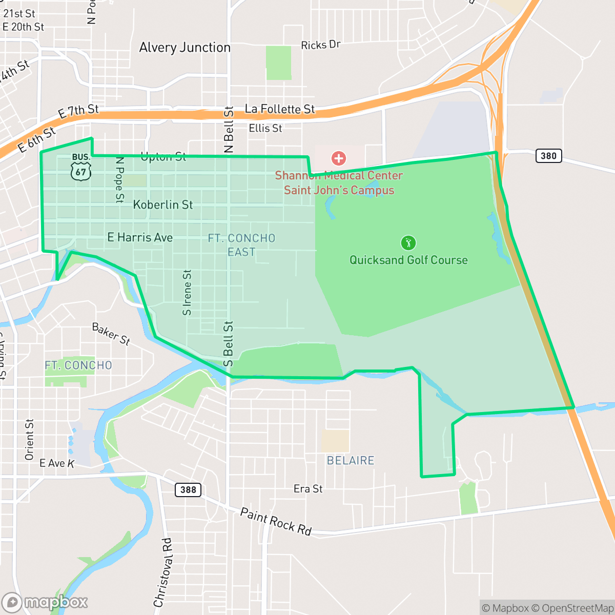
Fort Concho East is a quiet, car-dependent neighborhood in San Angelo characterized by a mix of suburban residential blocks and light industrial areas. The community offers a rural-leaning landscape with significant open spaces, though residents should note the area faces high flood risks and relies on vehicle travel for daily errands.
Key Highlights
About Fort Concho East
Fort Concho East features a blend of residential life and light industrial activity, situated near local railways and small bodies of water. The area maintains a quiet, low-density atmosphere with vast open spaces that distinguish it from the more urban centers of San Angelo. While it provides a serene environment for those seeking a more rural feel, the neighborhood remains largely car-dependent, with limited walkability and a lack of dense commercial development.
Prospective residents should be aware of specific livability trade-offs, including a high risk of flooding and below-average access to health insurance. While the neighborhood offers a peaceful setting with moderate acoustic comfort, it is best suited for individuals who prioritize space and quiet over immediate proximity to city amenities. According to iHuus data, families may find varying educational opportunities depending on their specific district zoning, as the area sits near both high-performing and distressed school systems.
Neighborhood Scores Across 15 Qualities
Residential spacing is typical for the area, providing a balance of proximity to neighbors and sufficient buffer between homes. According to iHuus data, privacy levels in this neighborhood are consistent with the San Angelo average.
Low traffic volume makes for pleasant strolls, though the lack of sidewalks makes walking less structured than in other parts of San Angelo.
Housing consists of typical tract-style homes with modest yards and simple rooflines. This visual profile is slightly below the San Angelo average according to iHuus data.
Access to public parks and green spaces is roughly comparable to the rest of San Angelo. Pet owners may find moderate opportunities for outdoor activity within the area.
Low-density land use prevails here, characterized by scattered residential clusters and industrial yards. According to iHuus data, this area maintains a slightly more open, semi-rural feel than the typical San Angelo urban landscape.
A balanced mix of residential streets, light industrial units, and local dining creates a level of activity that is slightly higher than the San Angelo average. According to iHuus data, the area offers a blend of quiet green spaces and accessible services, though some parts remain car-dependent near the railway and highway corridors.
A steady hum of local traffic from a nearby busy street is present. According to iHuus data, acoustic comfort in this area is slightly higher than the San Angelo average.
Residential life dominates the area with few industrial disturbances, though some light commercial activity is present. According to iHuus data, the proximity to heavy industrial zones is lower than the San Angelo average.
Health insurance enrollment among residents is lower than the San Angelo average, according to iHuus data.
Political leanings in this area are primarily conservative, representing a more right-leaning demographic than the San Angelo average according to iHuus data.
Residents will find a diverse demographic spread across various life stages, including young professionals, families, and seniors. This age distribution is slightly more varied than the typical profile found across San Angelo.
Property within this area is located in a 100-year floodplain, which may necessitate flood insurance. According to iHuus data, the risk level is slightly higher than the San Angelo city average.
Block-Level Insights for Fort Concho East

iHuus Neighborhood Intelligence Insights
Get block-level neighborhood insights for Fort Concho East
- Street-level scores — see how individual blocks compare, not just neighborhood averages
- Micro-zone boundaries — identify quiet pockets, flood boundaries, and walkable clusters before you visit
- 15 dimensions in full — walkability, noise, air quality, school quality, insurance coverage, population age profile, urban/rural index, and more
- Boundary risk alerts — know if your address sits near a block boundary where scores drop, the kind of detail no listing will ever mention
- School insights — individual school ratings and insights, not just district-level data
- Compare before you commit — side-by-side data across neighborhoods, down to block precision
No credit card required
Compare with Any Neighborhood
| Dimension | Fort Concho East | Angelo Heights |
|---|---|---|
| 🚶 Walkabilityavg 5.86 | ||
| 🔊 Acoustic Comfortavg 4.52 | ||
| 🤫 Privacy Indexavg 6.06 | ||
| 🎨 Visual Appealavg 5.61 | ||
| 🐕 Dog Friendlinessavg 5.82 | ||
| 🗺️ Urban-Rural Indexavg 7.3 | ||
| ✨ Neighborhood Vibeavg 4.15 | ||
| 🏥 Health Insurance Coverageavg 6.22 | ||
| 🌿 Air Quality | ||
| 🏭 Industrial Proximityavg 8.42 | ||
| 🌊 Flood Safetyavg 3.02 | ||
| 🗳️ Ideological Leanavg 1.23 | ||
| 👥 Population Age Profileavg 4.73 | ||
| 🔥 Fire Safety | ||
| 🏫 School Quality |
Fort Concho East Rankings
School Districts Serving Fort Concho East
Wall Independent School District is a 'Blue Chip' rural organization characterized by elite academic performance, robust community financial backing, and high leadership stability. With all primary campuses achieving top-tier state rankings and a recent 71% approval of a tax rate election, the district maintains a rare balance of growth (18% over a decade) and intimate student-teacher ratios. The 'Home of Champions' culture is supported by both 'A' rated TEA scores and dominant athletic programs, while the lack of opposition in recent board elections signals an unusually high level of community satisfaction and operational consistency.
Schools
San Angelo ISD is currently classified as a distressed district due to significant long-term enrollment decline and structural budget deficits that have necessitated controversial school closures. While the district maintains a solid 'C' rating with pockets of excellence in its top-tier elementary schools and successful bond-funded facility upgrades, the extreme performance gap between its highest and lowest-achieving campuses is concerning. Community trust is currently tested by transparency issues surrounding consolidation efforts and a shrinking student population that threatens future funding. Despite competitive teacher compensation plans and strong extracurricular successes, the district's operational health is strained by the need for aggressive rightsizing and stagnant secondary academic performance.
Schools
School Insights for Fort Concho East
Below average outcomes; significant attendance and academic challenges.
School Insights
See what's really behind every school rating near Fort Concho East
- Individual school ratings — each school's own score with outcome context, not just a district average
- Enrollment & class size data — student-to-teacher ratio and how it compares to the state average
- Full demographics breakdown — ethnicity and gender composition for every school in the enrollment zone
- Every school in the district — all schools within the enrollment boundary ranked by rating, not just the closest one
- Grade levels & benchmarks — elementary through high school, with below/above state-average flags
No credit card required