Northeast Torrance, Torrance
Updated · 11,756 residents
Northeast Torrance is a dense suburban community characterized by its post-war tract housing and a vibrant, diverse local dining scene. While residents enjoy access to top-rated schools and a consistent grid-based street layout, the area is marked by significant road noise and proximity to industrial zones.
Key Highlights
About Northeast Torrance
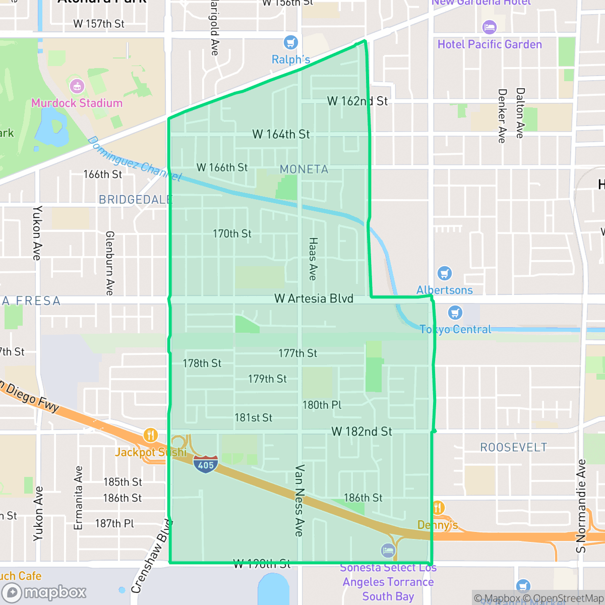
Northeast Torrance, situated in the 90504 zip code, is an established residential neighborhood with a housing stock largely built during the post-World War II boom of the 1940s to 1969. Characterized by quiet, tree-lined streets and local green spaces like Guenser Park, the neighborhood is known for its rich cultural diversity, particularly its prominent Japanese-American and broader Asian-American communities. Northeast Torrance's most culturally significant landmark is the Roadium Open Air Market, which opened as a drive-in theater in 1950. During the 1980s, the Roadium became a vital hub for the birth of West Coast hip-hop. It was at this swap meet that record vendor Steve Yano sold influential underground mixtapes and famously introduced Eric 'Eazy-E' Wright to Dr. Dre, paving the way for the formation of the legendary rap group N.W.A.
The neighborhood functions as a dense suburban environment, blending residential tracts with light industrial infrastructure. The streetscape is defined by uniform, boxy post-war homes and mature tree-lined streets that provide a consistent, grid-based layout for navigation. Local amenities are diverse, ranging from small parks like Guenser Park to a wide selection of international dining options that reflect the multicultural heritage of the area.
Prospective residents should consider the trade-offs of living in a mixed-use suburban zone. The area faces elevated road noise levels and proximity to industrial warehouses, which can impact acoustic comfort and air quality. While the neighborhood is highly walkable compared to many suburban regions, it also carries specific environmental considerations, including flood and fire safety risks. It remains a compelling choice for families who prioritize access to the high-performing Torrance Unified School District and a central location within the South Bay.
Neighborhood Scores Across 15 Qualities
Residential structures are often closely packed with minimal setbacks and shared property lines. This density is slightly higher than the Torrance average, particularly near apartment clusters and mobile home parks where separation between units is minimal.
Sidewalks are widely available on residential streets and many intersections feature clear crosswalks. While pedestrian access is consistent, major arterial roads and the nearby freeway can create significant barriers to movement compared to the city average.
Residential streetscapes consist primarily of standard tract housing with uniform rooflines and small yards. According to iHuus data, the visual variety in this area is slightly lower than the Torrance average.
Public spaces for pets are sparse, as the area features many industrial lots and narrow sidewalks with little access to open fields. According to iHuus data, walking options for dogs are below the Torrance average due to a lack of continuous green verges and large public parks.
Residential blocks are closely integrated with light industrial warehouses and large-scale commercial infrastructure. This landscape is largely consistent with the broader Torrance area.
A blend of quiet industrial pockets and lively dining hubs creates a social atmosphere that is roughly in line with the rest of Torrance. While some blocks offer diverse restaurant options near green spaces, much of the area remains car-dependent due to the presence of warehouses and freight corridors.
Frequent noise from nearby freeways and railroad tracks characterizes this area. According to iHuus data, acoustic comfort levels are consistent with the city average.
Air quality fluctuates between acceptable and unhealthy levels, presenting more frequent concerns for sensitive groups than the Torrance average. According to iHuus data, residents may experience occasional periods of diminished air clarity.
Industrial presence is minimal throughout most of the area, consisting primarily of residential, educational, and light commercial zones. While some larger warehouses and logistics centers are visible on the edges, the neighborhood features less industrial activity than the Torrance average.
Health insurance enrollment is lower than the Torrance average. According to iHuus data, a significant portion of the resident population remains uninsured.
Political leanings in this area trend more liberal than the Torrance average. According to iHuus data, the neighborhood maintains a liberal majority with a modest opposing presence.
Residents live alongside a balanced distribution of young adults, families, and older individuals, reflecting an age profile that is consistent with the Torrance city average.
Properties in this area are located within a designated floodplain, making flood insurance a common requirement for residents. According to iHuus data, the risk of flooding in Northeast Torrance is notably higher than the average found throughout Torrance.
Address-Level Insights for Northeast Torrance


iHuus Neighborhood Intelligence Insights
Get address-level neighborhood insights for Northeast Torrance
- Street-level scores — see how individual blocks compare, not just neighborhood averages
- Micro-zone boundaries — identify quiet pockets, flood boundaries, and walkable clusters before you visit
- 15 dimensions in full — walkability, noise, air quality, school quality, insurance coverage, population age profile, urban/rural index, and more
- Boundary risk alerts — know if your address sits near a block boundary where scores drop, the kind of detail no listing will ever mention
- School insights — individual school ratings and insights, not just district-level data
- Compare before you commit — side-by-side data across neighborhoods, down to block precision
No credit card required
Compare with Any Neighborhood
| Dimension | Northeast Torrance | Chatelaine |
|---|---|---|
| 🚶 Walkabilityavg 9.22 | ||
| 🔊 Acoustic Comfortavg 2.86 | ||
| 🤫 Privacy Indexavg 4.5 | ||
| 🎨 Visual Appealavg 6.49 | ||
| 🐕 Dog Friendlinessavg 5.97 | ||
| 🗺️ Urban-Rural Indexavg 6.5 | ||
| ✨ Neighborhood Vibeavg 4.9 | ||
| 🏥 Health Insurance Coverageavg 8.4 | ||
| 🌿 Air Qualityavg 7.82 | ||
| 🏭 Industrial Proximityavg 7.83 | ||
| 🌊 Flood Safetyavg 3.32 | ||
| 🗳️ Ideological Leanavg 7.66 | ||
| 👥 Population Age Profileavg 5.25 | ||
| 🔥 Fire Safetyavg 0.06 | ||
| 🏫 School Quality |
Northeast Torrance Rankings
School Districts Serving Northeast Torrance
School Insights for Northeast Torrance
Below average outcomes; significant attendance and academic challenges.
School Insights
See what's really behind every school rating near Northeast Torrance
- Individual school ratings — each school's own score with outcome context, not just a district average
- Enrollment & class size data — student-to-teacher ratio and how it compares to the state average
- Full demographics breakdown — ethnicity and gender composition for every school in the enrollment zone
- Every school in the district — all schools within the enrollment boundary ranked by rating, not just the closest one
- Grade levels & benchmarks — elementary through high school, with below/above state-average flags
No credit card required