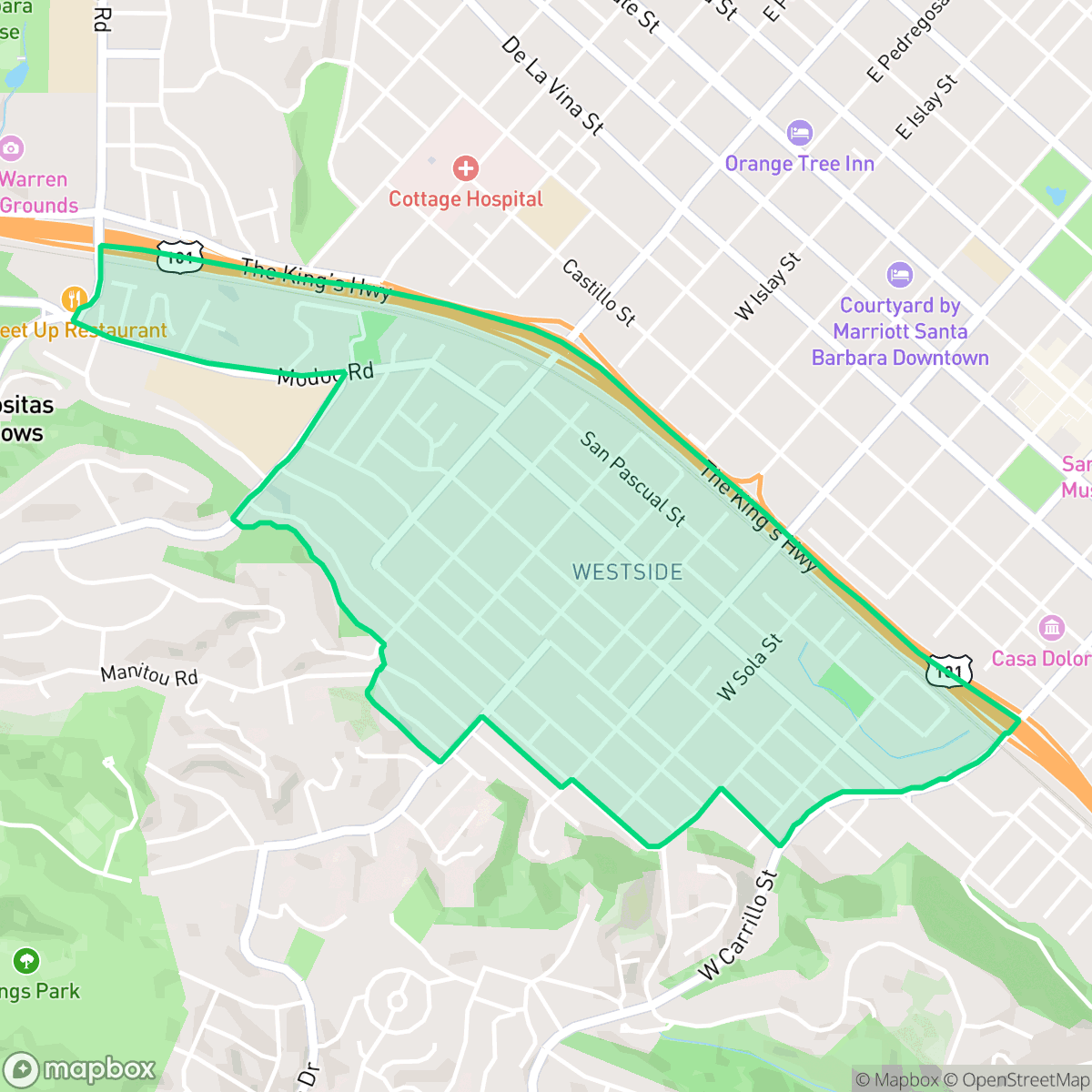
Westside, Santa Barbara
Updated June 22, 2026 · 8,198 residents
The Westside is a highly walkable neighborhood characterized by its blend of traditional cottages and hillside homes. While the area offers a semi-rural atmosphere with mature tree canopies, residents should be aware of elevated noise levels from nearby transit corridors and the requirement for flood insurance in certain sections.
Key Highlights
About Westside
The Westside of Santa Barbara, historically recognized as the city’s first suburb initiated by Anglo settlers, began as mid-19th-century grazing land and farmland. Following the 1850 U.S. annexation, the area was subdivided into small agricultural plots. The neighborhood evolved into a dense residential district, with over half of its housing stock predating 1940, featuring a mix of traditional cottages, bungalows, and Spanish-style architecture. Culturally, the Westside is noted for its diversity and deep-rooted Mexican-American heritage. Significant landmarks include the historic Cottage Hospital, established in 1891, and Oak Park, a long-standing community gathering space. The area also holds a unique place in cinematic history as the former site of the 'Flying A' film studio, which produced hundreds of silent films in the early 20th century.
This neighborhood stands out for its dense grid of sidewalks and pedestrian bridges, which provide superior accessibility compared to many other parts of the city. The area maintains a semi-rural feel, featuring sprawling hillsides and mature trees that offer a sense of seclusion despite the residential density. Residents enjoy a vibrant and active suburban lifestyle with convenient access to local dining and wellness services, though the community remains largely car-dependent for reaching broader leisure destinations. The housing stock is diverse, ranging from closely spaced cottages to isolated hillside estates, contributing to a varied visual landscape that avoids industrial intrusion entirely.
Prospective residents should consider several trade-offs when evaluating the area. According to iHuus data, the neighborhood experiences higher noise levels due to its proximity to the freeway and railroad traffic. Furthermore, the area is located within a designated floodplain, making flood insurance a standard requirement for many properties. While the community benefits from a diverse demographic and strong liberal leanings, it also faces challenges regarding health insurance accessibility for some residents. Families will find educational options through the Hope Elementary School District, which is recognized for stable academic outcomes, and the Santa Barbara Unified School District, which serves older students through a broader range of specialized programs.
Neighborhood Scores Across 15 Qualities
Housing proximity varies across the area, ranging from closely spaced homes with shared property lines to more isolated hillside residences. This level of density is slightly higher than the Santa Barbara average, according to iHuus data.
A dense grid of sidewalks and pedestrian bridges ensures easy movement throughout the area. According to iHuus data, this neighborhood offers superior pedestrian accessibility compared to the Santa Barbara average.
Large custom homes and well-manicured landscaping characterize much of the area, though some sections feature more standard tract-style housing. Overall visual aesthetics remain slightly below the Santa Barbara average according to iHuus data.
Walking opportunities for pets are constrained by narrow sidewalks and a lack of large public parks, making this area less dog friendly than the Santa Barbara average. While some tree lined streets provide shade, much of the neighborhood's greenery is situated on private or steep hillsides.
Sprawling hillsides with mature tree canopies and open greenspace provide a sense of seclusion that is slightly more suburban than the city average. Some pockets feature denser residential layouts, but the area maintains a significant presence of open land and woodland.
Social and local hubs are more concentrated here than in the city average, providing a steady rhythm of activity through various dining and wellness spots. While many blocks offer a calm suburban feel, the area remains largely car-dependent for accessing these leisure services.
Frequent noise from nearby freeway and railroad traffic impacts the area. According to iHuus data, acoustic comfort in this neighborhood is lower than the Santa Barbara average.
Air quality remains consistently high with minimal health concerns. This level of air purity is on par with the rest of Santa Barbara.
Industrial activity and warehouses are entirely absent from this area. Residents can expect a landscape composed solely of residential, institutional, and green spaces, which is slightly more disconnected from industrial zones than the city average.
Health insurance accessibility is notably lower in this area compared to the Santa Barbara average. According to iHuus data, a small portion of the resident population possesses health coverage.
Voting patterns and census indicators reflect a deeply liberal political leaning, slightly more pronounced than the city average according to iHuus data.
A varied demographic of young adults, families, and seniors resides here, representing a slightly more concentrated group of younger residents compared to the Santa Barbara average.
Properties in this area are located within a designated floodplain, which typically necessitates flood insurance. According to iHuus data, the risk level in Westside is higher than the Santa Barbara city average.
Block-Level Insights for Westside

iHuus Neighborhood Intelligence Insights
Get block-level neighborhood insights for Westside
- Street-level scores — see how individual blocks compare, not just neighborhood averages
- Micro-zone boundaries — identify quiet pockets, flood boundaries, and walkable clusters before you visit
- 15 dimensions in full — walkability, noise, air quality, school quality, insurance coverage, population age profile, urban/rural index, and more
- Boundary risk alerts — know if your address sits near a block boundary where scores drop, the kind of detail no listing will ever mention
- School insights — individual school ratings and insights, not just district-level data
- Compare before you commit — side-by-side data across neighborhoods, down to block precision
No credit card required
Compare with Any Neighborhood
| Dimension | Westside | Alta Mesa |
|---|---|---|
| 🚶 Walkabilityavg 8.12 | ||
| 🔊 Acoustic Comfortavg 3.7 | ||
| 🤫 Privacy Indexavg 5.66 | ||
| 🎨 Visual Appealavg 7.77 | ||
| 🐕 Dog Friendlinessavg 7.45 | ||
| 🗺️ Urban-Rural Indexavg 7.13 | ||
| ✨ Neighborhood Vibeavg 5.46 | ||
| 🏥 Health Insurance Coverageavg 6.92 | ||
| 🌿 Air Qualityavg 10 | ||
| 🏭 Industrial Proximityavg 9.73 | ||
| 🌊 Flood Safetyavg 3.72 | ||
| 🗳️ Ideological Leanavg 9.64 | ||
| 👥 Population Age Profileavg 5.23 | ||
| 🔥 Fire Safetyavg 0.32 | ||
| 🏫 School Quality |
Westside Rankings
School Districts Serving Westside
Hope Elementary School District is a high-performing, financially resilient 'basic aid' district characterized by top-tier academic outcomes and deep community integration. With CAASPP scores significantly outperforming state averages and a portfolio of highly-rated neighborhood schools, the district maintains a 'Blue Chip' reputation despite aging infrastructure. Current leadership is proactive in addressing facility needs through a proposed 2026 bond and has successfully implemented sustainability initiatives that reduce long-term overhead. While the small scale of the district limits programmatic variety, its stability, strong teacher retention, and robust parental fundraising make it a premier elementary-level destination in the Santa Barbara region.
Schools
Santa Barbara Unified is a high-achieving district currently facing a period of operational and demographic transition. While its high schools are premier academic institutions with robust specialized programs like the Dos Pueblos Engineering Academy, the district is struggling with a widening achievement gap and stark performance disparities between individual school sites. Operationally, the district is managing the challenges of a high cost-of-living area, including teacher retention issues and a steady 2% annual enrollment decline. Despite these fiscal headwinds and looming budget cuts, the successful implementation of 'Science of Reading' reforms and positive labor negotiations suggest a stable management team that is proactively addressing its structural and academic weaknesses.
Schools
School Insights for Westside
Below average outcomes; significant attendance and academic challenges.
School Insights
See what's really behind every school rating near Westside
- Individual school ratings — each school's own score with outcome context, not just a district average
- Enrollment & class size data — student-to-teacher ratio and how it compares to the state average
- Full demographics breakdown — ethnicity and gender composition for every school in the enrollment zone
- Every school in the district — all schools within the enrollment boundary ranked by rating, not just the closest one
- Grade levels & benchmarks — elementary through high school, with below/above state-average flags
No credit card required