Santa Barbara Municipal Airport, Santa Barbara
Updated June 22, 2026 · 972 residents
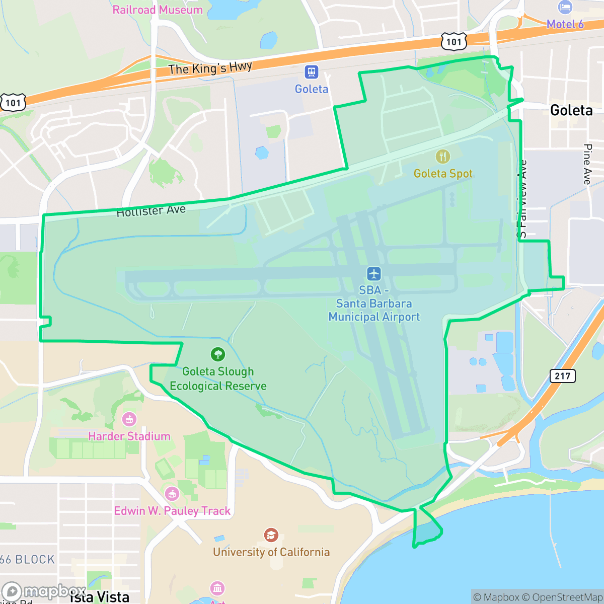
Defined by its expansive airfield and proximity to the Goleta Slough, this area offers a unique, low-density landscape dominated by aviation and utility infrastructure. While the neighborhood provides a quiet, open environment, residents must contend with significant noise levels from aircraft operations and proximity to industrial facilities.
Key Highlights
About Santa Barbara Municipal Airport
The Santa Barbara Municipal Airport neighborhood, situated on ancestral Chumash land near the Goleta Slough, began its aviation history in 1928 when pilots Royce Stetson and Gordon Sackett landed in a cow pasture near Hollister and Fairview Avenues. In 1931, the General Western Aero Corporation built two prominent hangars that still stand today. The City of Santa Barbara officially established the municipal airport in 1941, utilizing soil from Mescaltitlan Island to raise the airfield. During World War II, the site was transformed into Marine Corps Air Station Santa Barbara, a major military training base. Architecturally, the area is defined by its historic 1942 Spanish Colonial Revival terminal, designed by William Edwards and Joseph Plunkett. In 1960, the airport was annexed to Santa Barbara via a famous seven-mile-long underwater coastal corridor.
The area is characterized by its vast, open terrain that blends active aviation facilities with protected marshland. It functions primarily as a transit and industrial hub rather than a traditional residential district, featuring specialized infrastructure such as wastewater treatment facilities and light industrial units. The landscape remains largely non-residential, providing a stark contrast to the denser, more urbanized parts of Santa Barbara.
Prospective residents or visitors should note that the environment is notably loud due to ongoing runway activity and nearby transportation corridors. The area faces significant environmental challenges, including low flood and fire safety ratings, which are important considerations for long-term planning. While the neighborhood is highly dog-friendly and maintains excellent air quality, its industrial proximity and limited social amenities make it better suited for those prioritizing proximity to transit or specialized work environments over traditional residential livability.
Neighborhood Scores Across 15 Qualities
Residential spacing is slightly more varied than the city average, featuring a mix of dense housing and more spread out structures with significant buffer zones. According to iHuus data, this results in a balance of shared proximity and private common areas.
Dedicated paths and pedestrian-priority zones make navigating the area easy on foot. This level of accessibility is slightly above the Santa Barbara average, according to iHuus data.
Standard institutional architecture and tidy, small yards characterize the area. According to iHuus data, the visual landscape is less lush than the Santa Barbara average.
Abundant sports fields, parks, and wide grassy verges provide extensive space for pets. According to iHuus data, this area offers significantly more opportunities for canine exercise than the Santa Barbara average.
Open landscapes, marshlands, and airfield infrastructure dominate the area. This level of open space and low building density is consistent with the city average.
A blend of industrial and suburban activity defines the area, providing a variety of local amenities and dining options that are roughly comparable to the city average. While certain pockets feature social hubs and lifestyle services, the car-dependent street layouts limit walking accessibility.
Frequent aircraft noise from flight paths and proximity to transit infrastructure make this a significantly louder area than most of Santa Barbara. According to iHuus data, residents can expect much higher levels of ambient sound than the city average.
Air quality is consistently high with minimal health concerns. This level of cleanliness is on par with the Santa Barbara city average according to iHuus data.
Active airport operations and a wastewater treatment plant introduce more industrial activity and heavy vehicle traffic than is typically found in the wider Santa Barbara area. While much of the surroundings remain residential or academic, the presence of logistics hangars and aircraft runways creates a more industrial character compared to the city average.
Health insurance accessibility is notably higher here than the Santa Barbara average, according to iHuus data. This indicates a well-covered resident population with strong access to medical benefits.
Voting patterns and census indicators reflect a deeply liberal leaning, which is very similar to the broader Santa Barbara area. According to iHuus data, political leanings here align closely with the city average.
A significant majority of residents are young adults, representing a much younger demographic than the Santa Barbara average. According to iHuus data, there is a modest presence of families and older adults in the area.
Located in a coastal high-hazard zone subject to wave action, this area faces significantly higher flood risks than the Santa Barbara average. Residents should anticipate elevated or potentially prohibitive flood insurance costs according to iHuus data.
Block-Level Insights for Santa Barbara Municipal Airport

iHuus Neighborhood Intelligence Insights
Get block-level neighborhood insights for Santa Barbara Municipal Airport
- Street-level scores — see how individual blocks compare, not just neighborhood averages
- Micro-zone boundaries — identify quiet pockets, flood boundaries, and walkable clusters before you visit
- 15 dimensions in full — walkability, noise, air quality, school quality, insurance coverage, population age profile, urban/rural index, and more
- Boundary risk alerts — know if your address sits near a block boundary where scores drop, the kind of detail no listing will ever mention
- School insights — individual school ratings and insights, not just district-level data
- Compare before you commit — side-by-side data across neighborhoods, down to block precision
No credit card required
Compare with Any Neighborhood
| Dimension | Santa Barbara Municipal Airport | Alta Mesa |
|---|---|---|
| 🚶 Walkabilityavg 8.12 | ||
| 🔊 Acoustic Comfortavg 3.7 | ||
| 🤫 Privacy Indexavg 5.66 | ||
| 🎨 Visual Appealavg 7.77 | ||
| 🐕 Dog Friendlinessavg 7.45 | ||
| 🗺️ Urban-Rural Indexavg 7.13 | ||
| ✨ Neighborhood Vibeavg 5.46 | ||
| 🏥 Health Insurance Coverageavg 6.92 | ||
| 🌿 Air Qualityavg 10 | ||
| 🏭 Industrial Proximityavg 9.73 | ||
| 🌊 Flood Safetyavg 3.72 | ||
| 🗳️ Ideological Leanavg 9.64 | ||
| 👥 Population Age Profileavg 5.23 | ||
| 🔥 Fire Safetyavg 0.32 | ||
| 🏫 School Quality |
Santa Barbara Municipal Airport Rankings
School Districts Serving Santa Barbara Municipal Airport
Goleta Union Elementary School District is a high-performing and financially stable district characterized by strong academic results and successful long-term capital planning. With proficiency scores significantly outperforming California state averages and a successful $80 million Measure M bond program underway for infrastructure modernization, the district maintains high community trust and operational transparency. Although it faces common regional challenges such as moderate enrollment decline and achievement gaps in a few specific schools, its robust financial reserves, active parent engagement, and 'A-' rated academic standing solidify its position as a top-tier educational provider in the Santa Barbara area.
Schools
School Insights for Santa Barbara Municipal Airport
Below average outcomes; significant attendance and academic challenges.
School Insights
See what's really behind every school rating near Santa Barbara Municipal Airport
- Individual school ratings — each school's own score with outcome context, not just a district average
- Enrollment & class size data — student-to-teacher ratio and how it compares to the state average
- Full demographics breakdown — ethnicity and gender composition for every school in the enrollment zone
- Every school in the district — all schools within the enrollment boundary ranked by rating, not just the closest one
- Grade levels & benchmarks — elementary through high school, with below/above state-average flags
No credit card required