North Panhandle, San Francisco
Updated June 22, 2026 · 10,616 residents
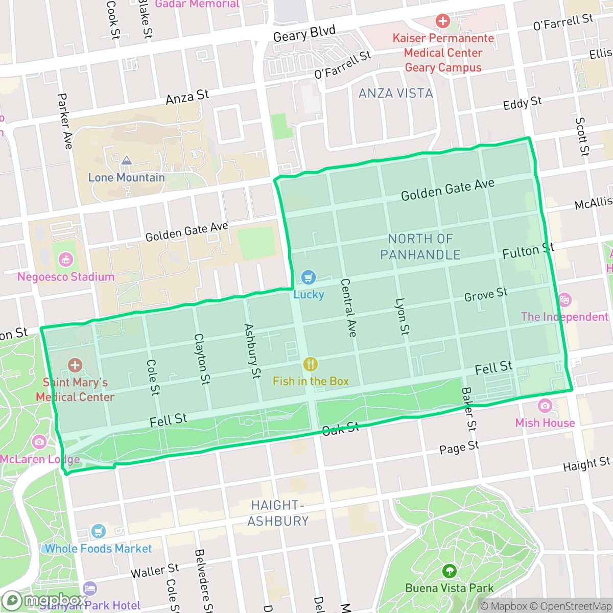
North Panhandle, or NoPa, is a highly walkable urban neighborhood defined by its dense collection of historic Victorian architecture and proximity to the expansive Panhandle park. Residents benefit from excellent pedestrian access and a vibrant local dining scene along Divisadero Street, though the area is characterized by tightly packed housing and significant road noise.
Key Highlights
About North Panhandle
Originally part of the windswept "Outside Lands" deeded to San Francisco in 1866, the North Panhandle (NoPa) neighborhood emerged as a streetcar suburb in the late 19th century. Its development was catalyzed by the adjacent Panhandle Park, created in 1870 as an experimental laboratory to stabilize the area's massive sand dunes. The neighborhood quickly filled with ornate Victorian and Edwardian homes. In the 1960s, NoPa was at the center of San Francisco's famous "freeway revolt," where grassroots community activism successfully defeated a proposed freeway that would have demolished the park and divided the neighborhood. Today, NoPa is defined by its beautifully preserved historic architecture and its bustling commercial corridor along Divisadero Street.
The area serves as a central hub for urban living, anchored by the commercial corridor of Divisadero Street. It offers a high density of multi-family residences and is exceptionally well-connected for those who prefer to navigate the city on foot. The presence of the adjacent park provides a critical green space for recreation, contributing to the neighborhood's status as a premier location for dog owners and outdoor enthusiasts.
Prospective residents should be aware of the trade-offs inherent to this high-density environment, including limited private outdoor space and ambient noise levels primarily driven by road traffic. While the neighborhood lacks heavy industrial activity and maintains high standards for air quality and health insurance coverage, the local school district currently faces significant fiscal and operational challenges. The area is best suited for individuals or small families who prioritize walkability and proximity to city amenities over quietude or expansive private residences.
Neighborhood Scores Across 15 Qualities
Buildings are tightly packed with many shared walls or very narrow gaps between structures. This level of density is consistent with the broader city average for San Francisco.
Extremely pedestrian-friendly infrastructure, featuring a continuous grid of wide sidewalks and frequent crosswalks, makes navigating this area on foot easier than in most of San Francisco. According to iHuus data, the dense urban layout and dedicated pedestrian-priority paths ensure high accessibility throughout the neighborhood.
Dense multi-unit housing and row houses define the area, providing a well-maintained but typical urban residential landscape. This level of visual character is largely in line with the broader San Francisco average.
Access to Golden Gate Park and several neighborhood green spaces provides much more room for pets than the typical San Francisco area. Extensive trail networks and connected parklands make walking dogs highly convenient according to iHuus data.
Residential blocks and multi-story buildings are interspersed with significant park infrastructure, creating a more suburban feel than the typical San Francisco urban core. This blend of dense street grids and accessible green space is slightly more balanced than the city average, according to iHuus data.
Lively pockets of dining and greenery coexist with quieter, suburban-style streets, offering a social atmosphere that is slightly less active than the city average. Residents can find diverse cafes and local landmarks, though some blocks feature fewer amenities than the broader San Francisco area according to iHuus data.
Frequent noise from nearby railroad tracks and major transit corridors creates a loud environment. This level of acoustic disturbance is slightly higher than the typical San Francisco experience according to iHuus data.
Air quality remains consistently good with rare instances of elevated readings, slightly exceeding the San Francisco average according to iHuus data.
Industrial hazards and heavy warehouses are absent from this area, which is slightly cleaner than the city average regarding industrial proximity. While a transit depot exists nearby, the neighborhood consists primarily of residential, institutional, and recreational spaces.
Health insurance enrollment among residents is exceptionally high, significantly outpacing the San Francisco average according to iHuus data.
Voting patterns and census indicators reflect a deeply liberal political leaning that is slightly more pronounced than the San Francisco average, according to iHuus data.
Residents live alongside a varied demographic of young professionals, families, and seniors. According to iHuus data, the age distribution is slightly more concentrated among specific age groups than the broader San Francisco average.
Flood risk is elevated in this area due to its location within a designated floodplain. According to iHuus data, this neighborhood carries a higher risk of flooding compared to the San Francisco average.
Block-Level Insights for North Panhandle

iHuus Neighborhood Intelligence Insights
Get block-level neighborhood insights for North Panhandle
- Street-level scores — see how individual blocks compare, not just neighborhood averages
- Micro-zone boundaries — identify quiet pockets, flood boundaries, and walkable clusters before you visit
- 15 dimensions in full — walkability, noise, air quality, school quality, insurance coverage, population age profile, urban/rural index, and more
- Boundary risk alerts — know if your address sits near a block boundary where scores drop, the kind of detail no listing will ever mention
- School insights — individual school ratings and insights, not just district-level data
- Compare before you commit — side-by-side data across neighborhoods, down to block precision
No credit card required
Compare with Any Neighborhood
| Dimension | North Panhandle | Alamo Square |
|---|---|---|
| 🚶 Walkabilityavg 9.91 | ||
| 🔊 Acoustic Comfortavg 3.4 | ||
| 🤫 Privacy Indexavg 2.14 | ||
| 🎨 Visual Appealavg 6.26 | ||
| 🐕 Dog Friendlinessavg 6.55 | ||
| 🗺️ Urban-Rural Indexavg 4.07 | ||
| ✨ Neighborhood Vibeavg 6.4 | ||
| 🏥 Health Insurance Coverageavg 7.87 | ||
| 🌿 Air Qualityavg 7.78 | ||
| 🏭 Industrial Proximityavg 9.37 | ||
| 🌊 Flood Safetyavg 1.89 | ||
| 🗳️ Ideological Leanavg 9.92 | ||
| 👥 Population Age Profileavg 5.18 | ||
| 🔥 Fire Safetyavg 0.01 | ||
| 🏫 School Quality |
North Panhandle Rankings
School Districts Serving North Panhandle
San Francisco Unified School District is currently in a state of operational and financial distress, characterized by a staggering $420 million budget deficit and state-level fiscal oversight. While the district maintains several world-class 'destination' schools and outperforms state averages in core proficiency, these successes are undermined by a profound achievement gap, with a high volume of schools performing at the bottom 10% of state rankings. Chronic enrollment loss, staffing challenges exacerbated by the high cost of living, and contentious board governance regarding curriculum and school closures have eroded community trust and stability, resulting in a 'distressed' rating despite the district's high-performing academic pockets.
Schools
School Insights for North Panhandle
Below average outcomes; significant attendance and academic challenges.
School Insights
See what's really behind every school rating near North Panhandle
- Individual school ratings — each school's own score with outcome context, not just a district average
- Enrollment & class size data — student-to-teacher ratio and how it compares to the state average
- Full demographics breakdown — ethnicity and gender composition for every school in the enrollment zone
- Every school in the district — all schools within the enrollment boundary ranked by rating, not just the closest one
- Grade levels & benchmarks — elementary through high school, with below/above state-average flags
No credit card required