East Industrial Complex, Irvine
Updated June 22, 2026 · 1,724 residents
The East Industrial Complex functions as a dense, utilitarian landscape dominated by large-scale warehouses and logistics hubs. While it offers high air quality and strong health insurance coverage, the area features limited walkability and consistent noise from road traffic.
Key Highlights
About East Industrial Complex
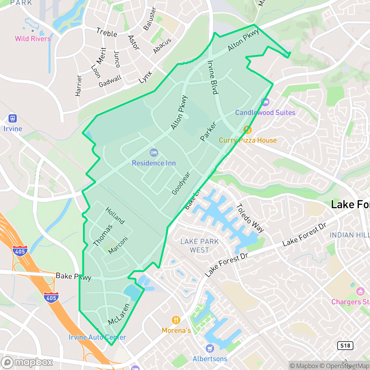
The East Industrial Complex in Irvine, California, traces its origins to 1975 when the Irvine Company opened the 2,000-acre development east of the El Toro Marine Corps Air Station. Along with its western counterpart, the complex formed the largest industrial development in the United States at the time. It was master-planned to capture rapidly expanding companies outgrowing nearby areas like Anaheim, Los Angeles, and the John Wayne Airport region. In 1984, the Irvine Company shifted its strategy from general industrial tenants to high-tech, research, and development firms, transforming a massive portion of the complex into a modern business park. This critical pivot laid the groundwork for the creation of the neighboring high-tech hub, the Irvine Spectrum.
This neighborhood is characterized by a dense, suburban industrial layout featuring large flat-roofed commercial structures, freight corridors, and utility facilities such as wastewater treatment plants. The environment is notably quiet and remote, with a mix of industrial operations and tightly packed residential mobile home communities. While the area provides essential services and religious centers, it remains a primarily functional zone designed for logistics rather than traditional residential living.
Living in this area involves specific trade-offs, as it prioritizes industrial utility over pedestrian-friendly amenities. Residents experience limited privacy and lower walkability, and the proximity to heavy freight traffic contributes to elevated road noise levels. However, the neighborhood benefits from excellent flood safety and superior access to healthcare, making it a practical location for those prioritizing proximity to work or specific industrial infrastructure.
Neighborhood Scores Across 15 Qualities
Structures are situated with narrow gaps between them, offering less separation than the typical Irvine neighborhood. According to iHuus data, the layout features a high-density arrangement where many buildings sit close to one another.
Pedestrians can utilize sidewalks and safe crossings within the area, though walking opportunities are less extensive than the Irvine average. Low traffic streets and cul-de-sacs provide a secure environment for walking according to iHuus data.
Large homes with private pools and well-maintained landscapes characterize this area. This level of visual upkeep is consistent with the typical aesthetic found across Irvine.
Wooded ravine trails and central park green buffers provide quality walking paths; however, overall pet-friendly features are below the Irvine average according to iHuus data.
Extensive warehouse footprints and large-scale commercial parking lots define this area. This landscape is largely comparable to the broader Irvine average in terms of open space and land use.
Predominantly quiet and remote, this area lacks the social energy found in more active parts of Irvine. Most locations are heavily centered around warehouses and freight corridors, making the neighborhood feel much more subdued than the city average.
Frequent acoustic disturbance from nearby freeway traffic and railroad activity characterizes this area. According to iHuus data, these noise levels are notably higher than the Irvine average.
Air quality remains consistently clean with rare instances of elevated readings. This level of freshness is notably higher than the Irvine average, according to iHuus data.
Heavy industrial activity and large-scale logistics hubs characterize this area, which features much higher levels of industrial density than the Irvine average. Residents should note the presence of a wastewater treatment plant and nearby large-scale warehouse operations with frequent freight traffic.
Health insurance coverage among residents is high, though slightly below the Irvine average according to iHuus data.
Political leanings in this area trend more conservative than the Irvine average, according to iHuus data.
A balanced mix of young adults, families, and older residents defines the local demographic. According to iHuus data, this age distribution is more varied than the city average.
Flood risk in this area is significantly lower than the Irvine average, though some residual risk exists within the 500-year floodplain according to iHuus data.
Extreme fire hazards are present in this area, representing a significantly higher risk level than the Irvine average according to iHuus data.
Block-Level Insights for East Industrial Complex

iHuus Neighborhood Intelligence Insights
Get block-level neighborhood insights for East Industrial Complex
- Street-level scores — see how individual blocks compare, not just neighborhood averages
- Micro-zone boundaries — identify quiet pockets, flood boundaries, and walkable clusters before you visit
- 15 dimensions in full — walkability, noise, air quality, school quality, insurance coverage, population age profile, urban/rural index, and more
- Boundary risk alerts — know if your address sits near a block boundary where scores drop, the kind of detail no listing will ever mention
- School insights — individual school ratings and insights, not just district-level data
- Compare before you commit — side-by-side data across neighborhoods, down to block precision
No credit card required
Compare with Any Neighborhood
| Dimension | East Industrial Complex | Business District |
|---|---|---|
| 🚶 Walkabilityavg 9.44 | ||
| 🔊 Acoustic Comfortavg 2.83 | ||
| 🤫 Privacy Indexavg 4.53 | ||
| 🎨 Visual Appealavg 7.36 | ||
| 🐕 Dog Friendlinessavg 7.98 | ||
| 🗺️ Urban-Rural Indexavg 6.69 | ||
| ✨ Neighborhood Vibeavg 4.63 | ||
| 🏥 Health Insurance Coverageavg 8.7 | ||
| 🌿 Air Qualityavg 6.22 | ||
| 🏭 Industrial Proximityavg 9.32 | ||
| 🌊 Flood Safetyavg 3.93 | ||
| 🗳️ Ideological Leanavg 7.23 | ||
| 👥 Population Age Profileavg 4.73 | ||
| 🔥 Fire Safetyavg 0.41 | ||
| 🏫 School Quality |
East Industrial Complex Rankings
School Districts Serving East Industrial Complex
Irvine Unified School District is a premier 'Blue Chip' organization characterized by exceptional academic consistency, financial stability, and high community trust. With nearly all schools performing at the highest state percentiles and high schools serving as national leaders in STEM and the arts, the district maintains a robust operational posture. While the district faces localized challenges regarding student mental health and rapid enrollment growth in new developments, its proactive facility investments and superior teacher quality rankings confirm its status as one of the most stable and high-performing educational entities in California.
Schools
SVUSD is a high-performing, stable school district characterized by an elite collection of top-tier high schools and a diverse range of successful elementary programs, earning it a 'Solid/Stable' rating. While the district is managing a 2% decline in enrollment—a common demographic trend in South Orange County—its operational health remains strong due to successful facility modernizations, high graduation rates (95%), and a proactive expansion of specialized CTE and dual-language tracks. Although a small subset of intermediate and alternative schools shows lower performance metrics, the district's overall portfolio remains highly desirable, bolstered by significant community support and a reputation for excellence in both academics and special education services.
Schools
School Insights for East Industrial Complex
Below average outcomes; significant attendance and academic challenges.
School Insights
See what's really behind every school rating near East Industrial Complex
- Individual school ratings — each school's own score with outcome context, not just a district average
- Enrollment & class size data — student-to-teacher ratio and how it compares to the state average
- Full demographics breakdown — ethnicity and gender composition for every school in the enrollment zone
- Every school in the district — all schools within the enrollment boundary ranked by rating, not just the closest one
- Grade levels & benchmarks — elementary through high school, with below/above state-average flags
No credit card required