Third World, San Antonio
Updated June 22, 2026 · 5,825 residents
Third World is a dense, quiet residential neighborhood anchored by its proximity to St. Mary's University. Residents experience a traditional grid street pattern with modest, tightly packed homes and minimal industrial noise.
Key Highlights
About Third World
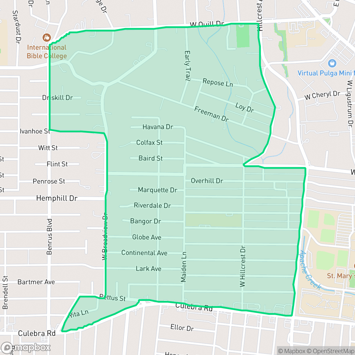
Historically designated as "Third World" (or "Third World S.A.") on digital maps and real estate databases, this San Antonio neighborhood surrounds St. Mary's University, which has anchored the area since 1894. Bounded by NW 36th Street, St. Cloud Road, West Huisache Avenue, and Culebra Road, the neighborhood has long been defined by its collegiate connection. In 2010, a neighborhood revitalization project spearheaded by the university and City Councilman Justin Rodriguez officially rebranded the area as the "St. Mary's Gateway District". The initiative brought infrastructure upgrades, including pocket parks, enhanced crosswalks, and bike lanes along Camino Santa Maria and Cincinnati Avenue. Despite the official name change, the "Third World" moniker persisted online, representing a community known for local student-friendly staples like Barrio Barista.
The area is characterized by a dense, suburban layout featuring single-story homes and a consistent grid street pattern. It maintains a relatively peaceful environment with an average noise level of 55 decibels, primarily driven by road traffic. The neighborhood benefits from its lack of industrial hazards, offering a predominantly residential landscape that integrates small green spaces and local community hubs near the university campus.
Prospective residents should note that the neighborhood presents specific trade-offs regarding infrastructure and safety. According to iHuus data, the area features inconsistent sidewalk coverage, which impacts overall walkability for pedestrians. Furthermore, the district faces significant challenges regarding flood safety, and prospective buyers should review local environmental reports carefully. It remains best suited for those seeking a quiet, student-adjacent community with a modest, suburban aesthetic.
Neighborhood Scores Across 15 Qualities
Residential structures feature a moderate density with varied setbacks between neighbors. This level of spacing is slightly higher than the San Antonio average, offering some buffer between closely packed homes on a suburban grid.
Low traffic volumes on residential streets allow for safe walking, though the sidewalk network is inconsistent and falls below the San Antonio average. Pedestrians may encounter stretches of road without dedicated paths, according to iHuus data.
Uniform tract housing and simple apartment blocks define the local landscape, which lacks the greenery and luxury amenities found elsewhere in San Antonio. Most lots feature small yards and minimal private landscaping according to iHuus data.
Greenery in this area is primarily contained within private fenced yards, with very few public parks or wide sidewalk verges available for walking. According to iHuus data, this lack of accessible public space makes the area less dog friendly than the San Antonio average.
Open land and scattered woodland characterize much of the area, though some parts feature a denser suburban grid. This landscape is slightly less developed than the typical San Antonio urban profile according to iHuus data.
Residential streets offer a calm, suburban atmosphere with a steady presence of local dining and services. Most daily activities require a vehicle due to a sparse landscape of walkable businesses, making the area slightly less active than the San Antonio average.
Steady sounds from nearby busy streets create a consistent ambient hum. According to iHuus data, this level of acoustic activity is slightly higher than the San Antonio average.
Frequent unhealthy air quality levels pose significant risks to sensitive groups. According to iHuus data, conditions in this area are slightly worse than the San Antonio average.
Residential and recreational spaces dominate the landscape, with a notable absence of warehouses or heavy industrial facilities. This area remains significantly clearer of industrial proximity than the San Antonio average, according to iHuus data.
Health insurance access among residents is lower than the San Antonio average. According to iHuus data, fewer people in this area possess medical coverage compared to the rest of the city.
Voting patterns and census indicators reflect a significantly more liberal leaning than the San Antonio average, according to iHuus data.
Residents live alongside a balanced mix of young adults, families, and seniors. This demographic spread is largely consistent with the broader San Antonio area.
Flood risk is significantly higher than the San Antonio average; residents should expect elevated or potentially prohibitive insurance costs due to the area's vulnerability to coastal high-hazard conditions.
Block-Level Insights for Third World

iHuus Neighborhood Intelligence Insights
Get block-level neighborhood insights for Third World
- Street-level scores — see how individual blocks compare, not just neighborhood averages
- Micro-zone boundaries — identify quiet pockets, flood boundaries, and walkable clusters before you visit
- 15 dimensions in full — walkability, noise, air quality, school quality, insurance coverage, population age profile, urban/rural index, and more
- Boundary risk alerts — know if your address sits near a block boundary where scores drop, the kind of detail no listing will ever mention
- School insights — individual school ratings and insights, not just district-level data
- Compare before you commit — side-by-side data across neighborhoods, down to block precision
No credit card required
Compare with Any Neighborhood
| Dimension | Third World | 145 Association |
|---|---|---|
| 🚶 Walkabilityavg 6.44 | ||
| 🔊 Acoustic Comfortavg 4.07 | ||
| 🤫 Privacy Indexavg 5.75 | ||
| 🎨 Visual Appealavg 6.11 | ||
| 🐕 Dog Friendlinessavg 5.91 | ||
| 🗺️ Urban-Rural Indexavg 6.87 | ||
| ✨ Neighborhood Vibeavg 4.35 | ||
| 🏥 Health Insurance Coverageavg 5.94 | ||
| 🌿 Air Qualityavg 2.27 | ||
| 🏭 Industrial Proximityavg 8.31 | ||
| 🌊 Flood Safetyavg 4.2 | ||
| 🗳️ Ideological Leanavg 7.37 | ||
| 👥 Population Age Profileavg 4.68 | ||
| 🔥 Fire Safety | ||
| 🏫 School Quality |
Third World Rankings
School Districts Serving Third World
Northside Independent School District remains a premier educational entity in the San Antonio region, characterized by elite-tier magnet programs and high-performing terminal high schools like Brandeis and O'Connor. While the district maintains a solid academic foundation and high community demand, it is navigating a complex transition period marked by a 2026 budget deficit, teacher retention concerns, and a notable performance disparity between its high-growth suburban campuses and its struggling urban elementary schools. Overall, its operational stability and reputation for collegiate preparation maintain its status as a top-tier choice for families, though recent financial constraints and overcrowding in the Helotes corridor represent emerging risks.
Schools
Edgewood Independent School District is a distressed organization currently undergoing a painful 'right-sizing' transition due to a 15% enrollment drop and persistent budget deficits. While specialized 'Innovation Schools' and robust CTE programs provide pockets of excellence and community pride, the broader portfolio suffers from extreme academic inconsistency, with multiple campuses performing at the lowest state percentiles. Despite investments in security and mission-driven faculty, the district faces significant operational risks including potential campus closures and leadership instability that overshadow its localized academic successes.
Schools
San Antonio ISD is currently a distressed district undergoing a high-stakes 'rightsizing' transformation to combat declining enrollment and a legacy of underfunded, aging facilities. While the district maintains prestigious, top-tier magnets like the Young Women's Leadership Academy, the broader portfolio is plagued by academic inconsistency, with nearly 40% of its schools rated 4/10 or lower. Despite a recent upgrade to a state 'C' rating and significant bond investment in infrastructure, the combination of a TEA corrective action plan for graduation rates, widespread literacy gaps, and the closure of 15 campuses reflects a system in a state of survival rather than stability.
Schools
School Insights for Third World
Below average outcomes; significant attendance and academic challenges.
School Insights
See what's really behind every school rating near Third World
- Individual school ratings — each school's own score with outcome context, not just a district average
- Enrollment & class size data — student-to-teacher ratio and how it compares to the state average
- Full demographics breakdown — ethnicity and gender composition for every school in the enrollment zone
- Every school in the district — all schools within the enrollment boundary ranked by rating, not just the closest one
- Grade levels & benchmarks — elementary through high school, with below/above state-average flags
No credit card required