Palm Heights, San Antonio
Updated · 14,125 residents
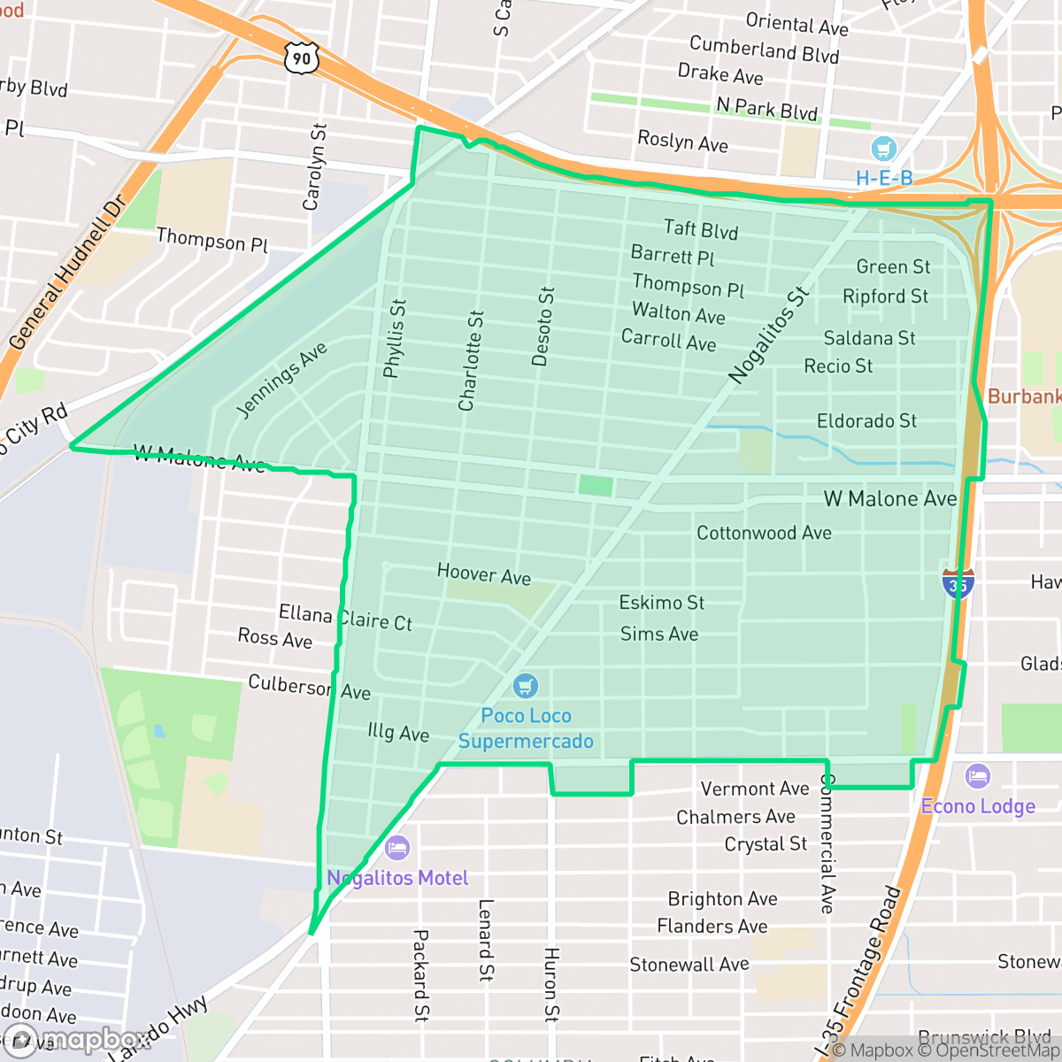
Palm Heights is a historic, predominantly Mexican-American neighborhood in southwest San Antonio defined by its early 20th-century bungalow architecture and central park. While the area offers a strong sense of local identity and authentic dining, it is a car-dependent community characterized by high traffic noise and limited walkability. Residents live in a dense suburban grid where homes are closely spaced with minimal privacy.
Key Highlights
About Palm Heights
Laid out in 1910 by developers Walton D. Hood, B. Louis Raborn, and J. Royston Williams, the Palm Heights neighborhood in southwest San Antonio was originally served by the San Fernando streetcar line. Following financial difficulties, the subdivision's streets and park were transferred to the city in 1928 by investor V.W. Mills. Today, the neighborhood is characterized by its early 20th-century Craftsman and bungalow-style homes. Its cultural and recreational heart remains Palm Heights Park (originally "Twin Parks"). The park features a historic community center designed by Wilder and Smith in 1931, which later received an addition in 1956 designed by famed River Walk architect Robert H. Hugman. Now a predominantly Mexican-American enclave, Palm Heights is celebrated for its deep-rooted working-class identity and authentic local character.
The neighborhood serves as a quiet, working-class residential enclave that balances a dense suburban layout with proximity to major transit corridors. Its streets are lined with modest Craftsman homes, and local life often centers around the community-focused amenities found within the park. According to iHuus data, the area experiences significant environmental challenges, including elevated road traffic noise and poor air quality, which are common for locations situated near major highways and industrial zones. Prospective residents should note that the area is best suited for those prioritizing a tight-knit community feel over modern luxury amenities. The neighborhood lacks extensive public green space beyond its central park, and the fragmented street grid limits pedestrian access to local services. With schools in the surrounding districts currently undergoing significant operational transitions, families should research specific campus performance. While the area offers an authentic cultural experience, the combination of high noise levels and flood risk factors requires careful consideration for long-term housing stability.
Neighborhood Scores Across 15 Qualities
Residential structures are closely spaced with minimal buffering between neighbors, resulting in a lower level of privacy than the San Antonio average.
Pedestrian movement is hindered by inconsistent sidewalks and barriers like highways or rail lines. While low-traffic residential streets allow for some walking, overall walkability is below the San Antonio average according to iHuus data.
Standard tract housing and uniform rooflines characterize the area, offering a simple aesthetic that is less visually varied than the San Antonio average. Small lot sizes and a lack of private luxury amenities, such as backyard pools, define much of the residential landscape according to iHuus data.
Access to public parks and wide green verges is sparse, with most greenery being confined to private fenced backyards. According to iHuus data, the availability of outdoor pet spaces is below the San Antonio average.
Developed residential grids and light industrial areas provide a suburban feel that is slightly less open than the San Antonio average. Large-scale warehouses and transit corridors coexist with single-family homes and apartment complexes across the area.
Suburban streets and light industrial areas create a steady but low-key atmosphere that is consistent with the city average. While various dining options and essential services are accessible, the area is largely car-dependent and lacks dense commercial activity.
Persistent noise from nearby major freeways and transit corridors makes this area louder than the San Antonio average. According to iHuus data, residents can expect frequent acoustic disturbances from heavy vehicle traffic.
Frequent unhealthy air quality levels pose a significant risk to sensitive groups. According to iHuus data, air quality in Palm Heights is slightly worse than the San Antonio average.
Industrial presence is minimal, consisting mainly of light commercial uses and small-scale storage. This area is slightly more industrial than the San Antonio average due to nearby warehouses and highway-related traffic.
Health insurance accessibility is lower than the San Antonio average. Residents may face greater challenges accessing covered medical services compared to other parts of the city.
Voting patterns and census indicators show a much more liberal leaning than the San Antonio average. Residents may find a community aligned with progressive social and political values according to iHuus data.
Residents live alongside a balanced blend of young adults, families, and seniors. According to iHuus data, this demographic distribution is largely consistent with the wider San Antonio area.
Flood vulnerability in this area is significantly higher than the San Antonio average, according to iHuus data. Residents should be aware of much greater susceptibility to rising waters compared to most parts of the city.
Address-Level Insights for Palm Heights


iHuus Neighborhood Intelligence Insights
Get address-level neighborhood insights for Palm Heights
- Street-level scores — see how individual blocks compare, not just neighborhood averages
- Micro-zone boundaries — identify quiet pockets, flood boundaries, and walkable clusters before you visit
- 15 dimensions in full — walkability, noise, air quality, school quality, insurance coverage, population age profile, urban/rural index, and more
- Boundary risk alerts — know if your address sits near a block boundary where scores drop, the kind of detail no listing will ever mention
- School insights — individual school ratings and insights, not just district-level data
- Compare before you commit — side-by-side data across neighborhoods, down to block precision
No credit card required
Compare with Any Neighborhood
| Dimension | Palm Heights | 145 Association |
|---|---|---|
| 🚶 Walkabilityavg 6.44 | ||
| 🔊 Acoustic Comfortavg 4.07 | ||
| 🤫 Privacy Indexavg 5.75 | ||
| 🎨 Visual Appealavg 6.11 | ||
| 🐕 Dog Friendlinessavg 5.91 | ||
| 🗺️ Urban-Rural Indexavg 6.87 | ||
| ✨ Neighborhood Vibeavg 4.35 | ||
| 🏥 Health Insurance Coverageavg 5.94 | ||
| 🌿 Air Qualityavg 2.27 | ||
| 🏭 Industrial Proximityavg 8.31 | ||
| 🌊 Flood Safetyavg 4.2 | ||
| 🗳️ Ideological Leanavg 7.37 | ||
| 👥 Population Age Profileavg 4.68 | ||
| 🔥 Fire Safety | ||
| 🏫 School Quality |
Palm Heights Rankings
School Districts Serving Palm Heights
School Insights for Palm Heights
Below average outcomes; significant attendance and academic challenges.
School Insights
See what's really behind every school rating near Palm Heights
- Individual school ratings — each school's own score with outcome context, not just a district average
- Enrollment & class size data — student-to-teacher ratio and how it compares to the state average
- Full demographics breakdown — ethnicity and gender composition for every school in the enrollment zone
- Every school in the district — all schools within the enrollment boundary ranked by rating, not just the closest one
- Grade levels & benchmarks — elementary through high school, with below/above state-average flags
No credit card required