Nevada Street, San Antonio
Updated June 22, 2026 · 2,361 residents
Nevada Street is a quiet, residential neighborhood on San Antonio’s East Side characterized by its dense grid of modest homes and accessible green spaces like Pittman-Sullivan Park. While the area offers a suburban rhythm and local dining options, residents contend with inconsistent sidewalk infrastructure and limited access to health insurance coverage.
Key Highlights
About Nevada Street
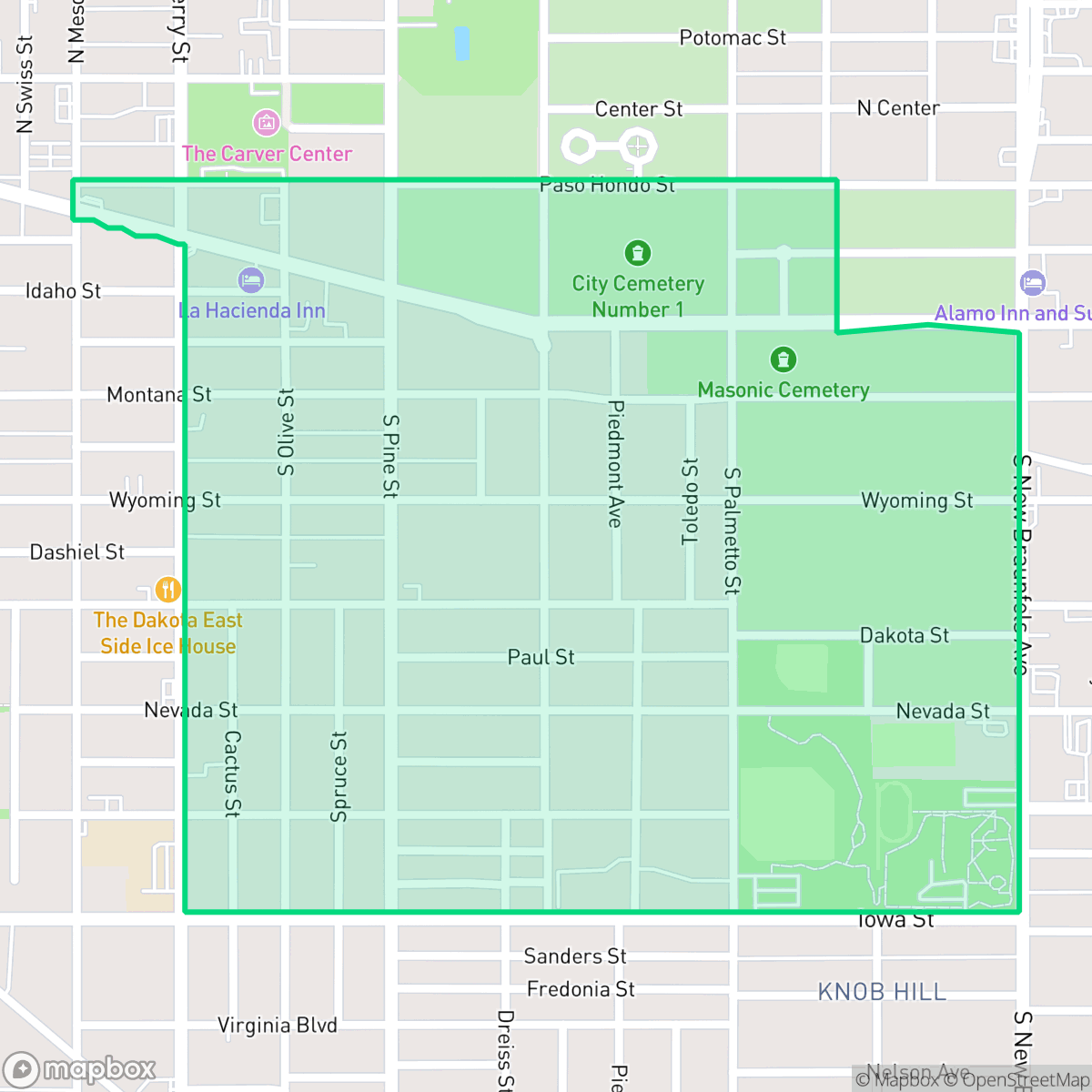
The Nevada Street neighborhood, situated on the East Side of San Antonio, Texas, developed in the late 19th and early 20th centuries as the city expanded eastward toward the Old San Antonio City Cemeteries Historic District, which borders the neighborhood to the north. Historically a vibrant hub for the city's African American community, the neighborhood is home to the historic Holy Redeemer Catholic Church on Nevada Street. Established in 1901, Holy Redeemer originally served Black residents during the segregation era and stands today as San Antonio's last remaining traditionally Black Catholic parish. The area's early community advocacy was championed by the Nevada Street Neighborhood Club, which later became the Denver Heights Neighborhood Association.
The neighborhood functions as a quiet, residential enclave defined by its compact, grid-based layout and proximity to local landmarks like Mark's Outing and Taqueria Los Dos Laredos. Residents benefit from significant green space, particularly at the centrally located Pittman-Sullivan Park, which serves as a primary hub for community activity and dog walking. The area maintains a consistent acoustic environment, balancing its suburban character with small-scale commercial clusters located along its periphery.
Prospective residents should note that the area presents specific trade-offs, including aging infrastructure and inconsistent sidewalk connectivity that impacts overall walkability. The local school system, managed by the San Antonio Independent School District, is currently undergoing significant restructuring, which may influence educational planning for families. Additionally, the neighborhood faces challenges regarding air quality and low rates of health insurance coverage, factors that prospective residents should consider when evaluating the local living environment.
Neighborhood Scores Across 15 Qualities
Residential structures feature mixed spacing with some proximity between neighbors. This level of density is slightly higher than the San Antonio average, as some areas contain closely packed housing on a tight grid.
Walking is possible due to low-traffic streets and a structured grid, though the lack of consistent sidewalks makes it slightly less walkable than the San Antonio average. Navigating near major arterial roads can be difficult because dedicated pedestrian paths are often missing or obscured.
High structure density and minimal greenery characterize this area. The landscape features modest homes on compact lots with noticeably less landscaping and fewer amenities than the San Antonio average.
Access to a centrally located park with baseball fields and green space makes this area more dog friendly than the San Antonio average. Most residential lots feature private fenced backyards, though sidewalk verges are minimal.
Open land and scattered residential clusters create a semi-rural feel that is slightly less dense than the San Antonio average. According to iHuus data, the area features a balanced mix of single-family homes and small commercial pockets nestled among greenery.
Suburban streets and green spaces offer a steady, low-energy rhythm that is less active than the San Antonio average. While diverse dining and parks are accessible, the area remains primarily a quiet residential setting oriented toward daily convenience.
Steady hum from local traffic persists near busy thoroughfares. This level of sound is notably higher than the average for San Antonio.
Frequent unhealthy air quality levels pose a significant risk to sensitive groups. According to iHuus data, the air quality in this area is worse than the San Antonio average.
Industrial presence is minimal within this area, as the neighborhood is almost entirely residential with no heavy industrial hazards or large warehouses detected. This lack of industrial activity is even more pronounced here than in the broader San Antonio area.
Health insurance coverage among residents is notably lower than the San Antonio average. According to iHuus data, a small portion of the local population maintains medical coverage.
Voting patterns and census indicators show a predominantly liberal political leaning that is notably higher than the San Antonio average.
Residents live among a diverse mix of young adults, families, and seniors. This age distribution is largely consistent with the broader San Antonio area according to iHuus data.
Flood risk is significant in this area because it sits within a designated floodplain. According to iHuus data, the danger of flooding here is much higher than the San Antonio average.
Block-Level Insights for Nevada Street

iHuus Neighborhood Intelligence Insights
Get block-level neighborhood insights for Nevada Street
- Street-level scores — see how individual blocks compare, not just neighborhood averages
- Micro-zone boundaries — identify quiet pockets, flood boundaries, and walkable clusters before you visit
- 15 dimensions in full — walkability, noise, air quality, school quality, insurance coverage, population age profile, urban/rural index, and more
- Boundary risk alerts — know if your address sits near a block boundary where scores drop, the kind of detail no listing will ever mention
- School insights — individual school ratings and insights, not just district-level data
- Compare before you commit — side-by-side data across neighborhoods, down to block precision
No credit card required
Compare with Any Neighborhood
| Dimension | Nevada Street | 145 Association |
|---|---|---|
| 🚶 Walkabilityavg 6.44 | ||
| 🔊 Acoustic Comfortavg 4.07 | ||
| 🤫 Privacy Indexavg 5.75 | ||
| 🎨 Visual Appealavg 6.11 | ||
| 🐕 Dog Friendlinessavg 5.91 | ||
| 🗺️ Urban-Rural Indexavg 6.87 | ||
| ✨ Neighborhood Vibeavg 4.35 | ||
| 🏥 Health Insurance Coverageavg 5.94 | ||
| 🌿 Air Qualityavg 2.27 | ||
| 🏭 Industrial Proximityavg 8.31 | ||
| 🌊 Flood Safetyavg 4.2 | ||
| 🗳️ Ideological Leanavg 7.37 | ||
| 👥 Population Age Profileavg 4.68 | ||
| 🔥 Fire Safety | ||
| 🏫 School Quality |
Nevada Street Rankings
School Districts Serving Nevada Street
San Antonio ISD is currently a distressed district undergoing a high-stakes 'rightsizing' transformation to combat declining enrollment and a legacy of underfunded, aging facilities. While the district maintains prestigious, top-tier magnets like the Young Women's Leadership Academy, the broader portfolio is plagued by academic inconsistency, with nearly 40% of its schools rated 4/10 or lower. Despite a recent upgrade to a state 'C' rating and significant bond investment in infrastructure, the combination of a TEA corrective action plan for graduation rates, widespread literacy gaps, and the closure of 15 campuses reflects a system in a state of survival rather than stability.
Schools
School Insights for Nevada Street
Below average outcomes; significant attendance and academic challenges.
School Insights
See what's really behind every school rating near Nevada Street
- Individual school ratings — each school's own score with outcome context, not just a district average
- Enrollment & class size data — student-to-teacher ratio and how it compares to the state average
- Full demographics breakdown — ethnicity and gender composition for every school in the enrollment zone
- Every school in the district — all schools within the enrollment boundary ranked by rating, not just the closest one
- Grade levels & benchmarks — elementary through high school, with below/above state-average flags
No credit card required