Laddie Place and North Wilson, San Antonio
Updated June 22, 2026 · 6,061 residents
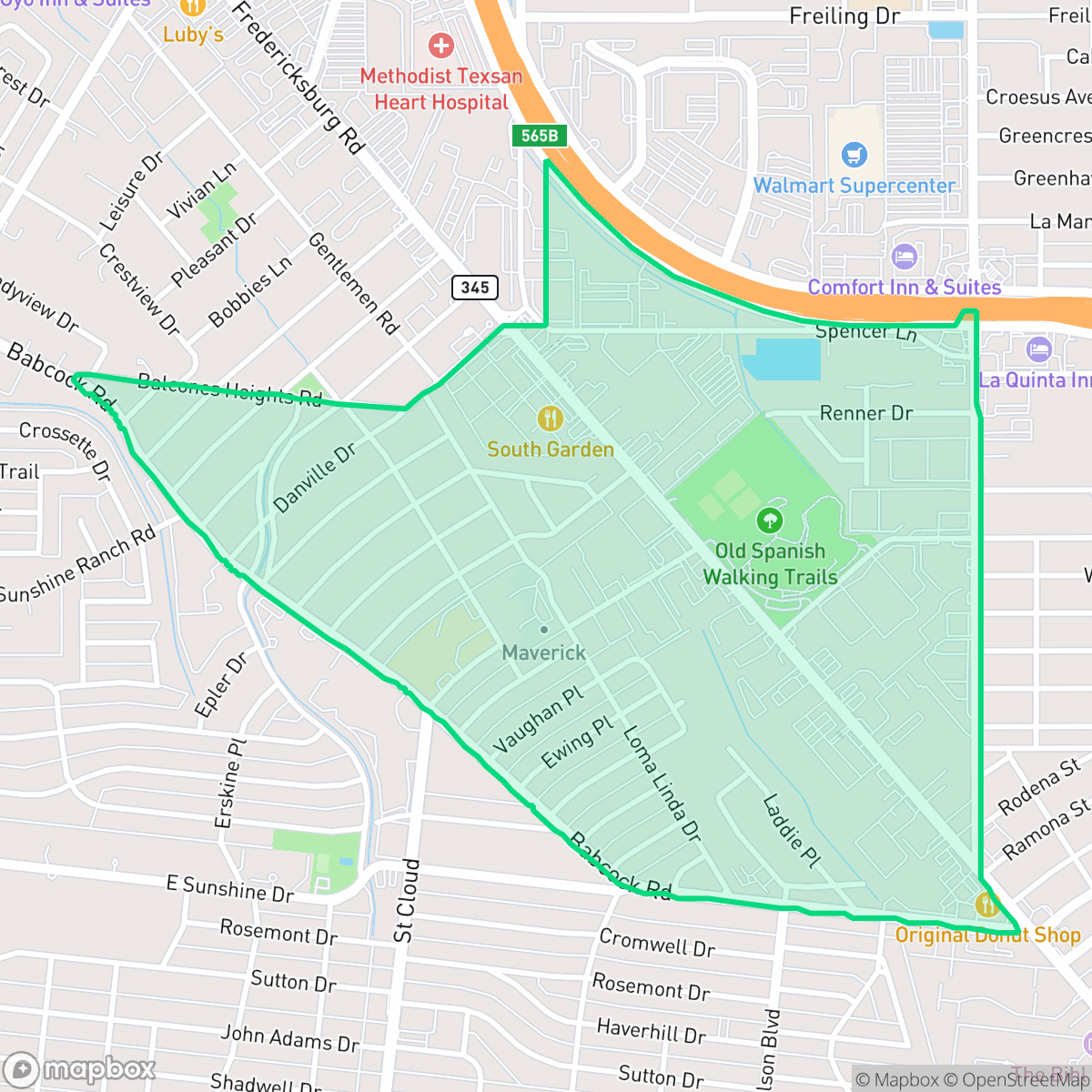
Laddie Place and North Wilson is a dense suburban neighborhood in San Antonio characterized by a grid street pattern and proximity to major highway corridors. Residents benefit from a walkable environment with access to local dining and park space, though the area experiences notable noise from road traffic.
Key Highlights
About Laddie Place and North Wilson
Located in San Antonio, this neighborhood features a mix of single-family homes and multi-family apartment complexes. The area maintains a suburban atmosphere with a grid-based street layout that facilitates pedestrian movement. Notable local dining options include Cafe Rosa, Taqueria Jimador, and Afghan Village Restaurant, which contribute to the community's modest commercial character. The neighborhood is situated near important transit routes, providing residents with connectivity to the wider city.
Living in the area requires balancing accessibility with the realities of urban life near a major highway. While the presence of local parks and sports fields offers outdoor opportunities, residents should be aware of the 59 dB noise levels from road traffic and the industrial presence in the northeast quadrant. The neighborhood is served by the San Antonio Independent School District, with Maverick Elementary School acting as a primary local option for families. It is best suited for those who prioritize walkability and proximity to essential services over absolute quiet.
Neighborhood Scores Across 15 Qualities
Residential density is roughly in line with the San Antonio average, featuring a mix of closely spaced houses and some multi-family clusters. According to iHuus data, some areas offer more buffer between neighbors while others consist of higher density apartment complexes.
Main roads feature a continuous sidewalk network and safe crossings, though residential streets often have inconsistent or tree-obscured paths. Pedestrian connectivity in this area is roughly in line with the San Antonio average according to iHuus data.
Modest yards and consistent tract housing define the visual landscape, which is roughly in line with the San Antonio average. According to iHuus data, the area features simple roof geometries and mid-range apartment complexes without significant luxury amenities.
Dog walking options are primarily restricted to private backyards or a single nearby sports field, which is below the San Antonio average. According to iHuus data, the area lacks wide sidewalk verges or accessible public parkland for off-leash exercise.
A dense suburban landscape characterizes this area, featuring a combination of single-family homes, multi-story apartment complexes, and commercial strips. This environment is slightly less open than the typical San Antonio setting, offering more built-up density than the city average.
A balanced mix of residential streets and light commercial services provides a slightly more active atmosphere than the San Antonio average. While diverse dining and social hubs exist, many daily errands will require a vehicle due to the car-dependent nature of the area.
Consistent sounds from nearby busy streets are present; however, acoustic levels remain slightly more tranquil than the San Antonio average.
Frequent periods of unhealthy air quality pose a significant risk to sensitive groups. According to iHuus data, air quality in this area is worse than the San Antonio average.
Primarily residential with light commercial use, this area avoids heavy industrial hazards. Some noise from large warehouses and logistics centers is present near the eastern edge and highway corridor, though the area remains slightly more industrial than the San Antonio average.
Health insurance access is notably lower in this area than in the rest of San Antonio, according to iHuus data. Residents may find fewer local options for employer-sponsored or private coverage within the immediate vicinity.
Voting patterns and census indicators reflect a significantly more liberal leaning than the San Antonio average. This political profile is consistent with the broader trends identified in iHuus data for this area.
A balanced mix of young adults, families, and seniors defines the local demographic. According to iHuus data, this age distribution is slightly more varied than the San Antonio city average.
Flood risk in this area is roughly in line with the San Antonio average, though FEMA has not yet completed a detailed study for this specific location. According to iHuus data, the precise level of exposure remains unverified.
Block-Level Insights for Laddie Place and North Wilson

iHuus Neighborhood Intelligence Insights
Get block-level neighborhood insights for Laddie Place and North Wilson
- Street-level scores — see how individual blocks compare, not just neighborhood averages
- Micro-zone boundaries — identify quiet pockets, flood boundaries, and walkable clusters before you visit
- 15 dimensions in full — walkability, noise, air quality, school quality, insurance coverage, population age profile, urban/rural index, and more
- Boundary risk alerts — know if your address sits near a block boundary where scores drop, the kind of detail no listing will ever mention
- School insights — individual school ratings and insights, not just district-level data
- Compare before you commit — side-by-side data across neighborhoods, down to block precision
No credit card required
Compare with Any Neighborhood
| Dimension | Laddie Place and North Wilson | 145 Association |
|---|---|---|
| 🚶 Walkabilityavg 6.44 | ||
| 🔊 Acoustic Comfortavg 4.07 | ||
| 🤫 Privacy Indexavg 5.75 | ||
| 🎨 Visual Appealavg 6.11 | ||
| 🐕 Dog Friendlinessavg 5.91 | ||
| 🗺️ Urban-Rural Indexavg 6.87 | ||
| ✨ Neighborhood Vibeavg 4.35 | ||
| 🏥 Health Insurance Coverageavg 5.94 | ||
| 🌿 Air Qualityavg 2.27 | ||
| 🏭 Industrial Proximityavg 8.31 | ||
| 🌊 Flood Safetyavg 4.2 | ||
| 🗳️ Ideological Leanavg 7.37 | ||
| 👥 Population Age Profileavg 4.68 | ||
| 🔥 Fire Safety | ||
| 🏫 School Quality |
Laddie Place and North Wilson Rankings
School Districts Serving Laddie Place and North Wilson
San Antonio ISD is currently a distressed district undergoing a high-stakes 'rightsizing' transformation to combat declining enrollment and a legacy of underfunded, aging facilities. While the district maintains prestigious, top-tier magnets like the Young Women's Leadership Academy, the broader portfolio is plagued by academic inconsistency, with nearly 40% of its schools rated 4/10 or lower. Despite a recent upgrade to a state 'C' rating and significant bond investment in infrastructure, the combination of a TEA corrective action plan for graduation rates, widespread literacy gaps, and the closure of 15 campuses reflects a system in a state of survival rather than stability.
Schools
School Insights for Laddie Place and North Wilson
Below average outcomes; significant attendance and academic challenges.
School Insights
See what's really behind every school rating near Laddie Place and North Wilson
- Individual school ratings — each school's own score with outcome context, not just a district average
- Enrollment & class size data — student-to-teacher ratio and how it compares to the state average
- Full demographics breakdown — ethnicity and gender composition for every school in the enrollment zone
- Every school in the district — all schools within the enrollment boundary ranked by rating, not just the closest one
- Grade levels & benchmarks — elementary through high school, with below/above state-average flags
No credit card required