North Houston District, Houston
Updated June 22, 2026 · 51,080 residents
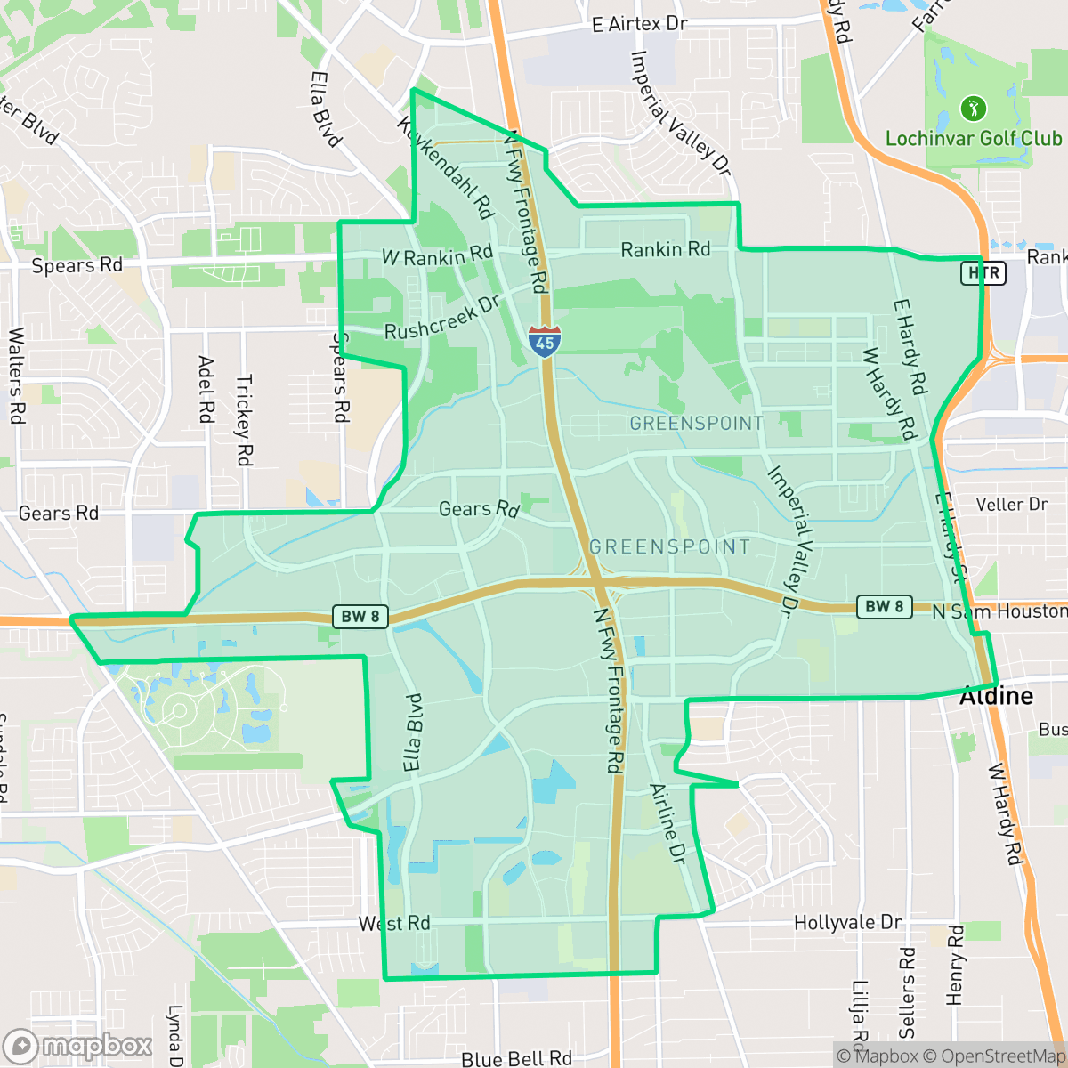
The North Houston District is a bustling commercial and industrial hub situated at the intersection of Interstate 45 and Beltway 8. The area features a dense mix of multi-family housing, large-scale logistics warehouses, and convenient access to diverse local dining. Residents here experience a car-dependent environment with significant industrial activity and limited privacy due to high-density development.
Key Highlights
About North Houston District
The North Houston District, historically known as Greater Greenspoint, originated as a planned "edge city" following the 1969 opening of the nearby George Bush Intercontinental Airport, which transformed the intersection of Interstate 45 and Beltway 8 into a major commercial crossroads. Real estate development accelerated in 1976 with the opening of Greenspoint Mall, a state-of-the-art enclosed shopping center. This catalyzed a massive wave of office and residential construction led by the Friendswood Development Company, an Exxon affiliate. To manage rapid growth and public safety, the Texas Legislature established the management district in 1991. Bisected by Greens Bayou, the district has faced significant flooding challenges, prompting the conversion of flood-prone areas into local green spaces like Thomas R. Wussow Park and CityView Park to improve community resilience.
This area functions primarily as a logistics and commercial gateway, defined by its proximity to George Bush Intercontinental Airport and major freight corridors. The landscape is dominated by large-scale warehouses, mid-rise office buildings, and densely packed residential apartment complexes. While the neighborhood lacks the amenities of a traditional walkable urban center, it offers a variety of casual dining options and social hubs that serve the local workforce and residents. Public green spaces, such as Thomas R. Wussow Park, provide essential outdoor relief and dog-friendly paths amidst the heavy industrial infrastructure. Prospective residents should consider that the area is characterized by high noise levels from highway traffic and industrial operations, alongside challenges regarding air quality and flood safety. Education options are split between the Aldine and Spring Independent School Districts, which present a mix of academic struggles and specialized high-performing choice programs. Given the car-dependent layout and industrial proximity, the district is best suited for individuals who prioritize proximity to major employment centers and transit corridors over a quiet, suburban residential experience.
Neighborhood Scores Across 15 Qualities
Residential spacing varies significantly across the district, with some areas featuring closely packed multi-family units and others offering moderate buffers between structures. According to iHuus data, the level of separation between neighbors is slightly lower than the Houston average.
Sidewalk connectivity is inconsistent throughout the district. While residential clusters and park trails offer safe paths, major highways and large parking lots create significant barriers to continuous pedestrian travel, making the area less walkable than the Houston average.
Standard tract housing and multi-family apartment complexes define the landscape, characterized by uniform rooflines and modest yards. According to iHuus data, the visual variety in this area is slightly lower than the Houston average.
Walking paths along the central canal and access to wooded park areas provide reliable space for pets. This level of access to greenery for dog walking is on par with the city average.
Large-scale warehouse districts and industrial logistics zones frequently border residential pockets and apartment complexes. This landscape of suburban sprawl and significant paved areas is largely in line with the typical density found across Houston.
A mix of warehouses, freight corridors, and green spaces creates a calm, low-activity environment. While some pockets offer diverse dining options, most social destinations are sparse and require a car to access.
Local traffic from nearby busy streets creates a consistent background hum. This level of acoustic activity is typical for the broader Houston area, according to iHuus data.
Frequent unhealthy air quality levels pose a significant risk to sensitive groups. According to iHuus data, pollution levels in this area are notably worse than the Houston city average.
A combination of logistics hubs, warehouses, and utility infrastructure exists alongside residential areas. This presence of heavy truck traffic and large-scale distribution centers is higher than the city average.
Health insurance access is significantly lower here than the Houston average. Residents may face greater challenges accessing medical services due to the lack of coverage within the community.
Voting patterns and census indicators show a predominantly liberal political leaning, which is notably more progressive than the Houston city average.
Residents will find a balanced distribution of young adults, families, and older individuals, though the population skews slightly younger than the Houston average according to iHuus data.
Flood risk in this area is difficult to determine because official FEMA studies for the district are currently incomplete. According to iHuus data, the level of safety from flooding is notably lower than the Houston city average.
Block-Level Insights for North Houston District

iHuus Neighborhood Intelligence Insights
Get block-level neighborhood insights for North Houston District
- Street-level scores — see how individual blocks compare, not just neighborhood averages
- Micro-zone boundaries — identify quiet pockets, flood boundaries, and walkable clusters before you visit
- 15 dimensions in full — walkability, noise, air quality, school quality, insurance coverage, population age profile, urban/rural index, and more
- Boundary risk alerts — know if your address sits near a block boundary where scores drop, the kind of detail no listing will ever mention
- School insights — individual school ratings and insights, not just district-level data
- Compare before you commit — side-by-side data across neighborhoods, down to block precision
No credit card required
Compare with Any Neighborhood
| Dimension | North Houston District | Acres Home |
|---|---|---|
| 🚶 Walkabilityavg 7.08 | ||
| 🔊 Acoustic Comfortavg 4.14 | ||
| 🤫 Privacy Indexavg 5.34 | ||
| 🎨 Visual Appealavg 6.42 | ||
| 🐕 Dog Friendlinessavg 6.33 | ||
| 🗺️ Urban-Rural Indexavg 6.64 | ||
| ✨ Neighborhood Vibeavg 4.4 | ||
| 🏥 Health Insurance Coverageavg 5.46 | ||
| 🌿 Air Qualityavg 3.58 | ||
| 🏭 Industrial Proximityavg 6.9 | ||
| 🌊 Flood Safetyavg 6.27 | ||
| 🗳️ Ideological Leanavg 6.39 | ||
| 👥 Population Age Profileavg 4.6 | ||
| 🔥 Fire Safety | ||
| 🏫 School Quality |
North Houston District Rankings
School Districts Serving North Houston District
Aldine ISD is a district in transition, characterized by a high-performing portfolio of specialized choice schools and high schools contrasted with deep academic struggles in its traditional middle school feeders. While ground truth data shows several campuses at 2/10 and 4/10 proficiency levels, the district's operational health is stabilized by proactive teacher retention strategies, successful bond-funded modernization, and expanding dual-enrollment partnerships. Leadership is effectively leveraging 'Choice Schools' as a driver for excellence, though the gap between these elite programs and neighborhood schools remains the primary barrier to 'Blue Chip' status.
Schools
Spring ISD is currently a distressed district characterized by a severe academic divide and the looming threat of a Texas Education Agency takeover. While the district has successfully secured an $850 million bond for facilities and has earned national recognition for its industry-leading campus security and active shooter preparedness, these operational successes are overshadowed by chronic underperformance. With nearly half of its schools rated as 'D' or 'F' by the state and major high schools consistently failing to meet proficiency standards, the district remains in a precarious transition period where administrative efforts and significant capital investments have yet to translate into widespread classroom success.
Schools
School Insights for North Houston District
Below average outcomes; significant attendance and academic challenges.
School Insights
See what's really behind every school rating near North Houston District
- Individual school ratings — each school's own score with outcome context, not just a district average
- Enrollment & class size data — student-to-teacher ratio and how it compares to the state average
- Full demographics breakdown — ethnicity and gender composition for every school in the enrollment zone
- Every school in the district — all schools within the enrollment boundary ranked by rating, not just the closest one
- Grade levels & benchmarks — elementary through high school, with below/above state-average flags
No credit card required