Magnolia Park, Houston
Updated June 22, 2026 · 19,065 residents
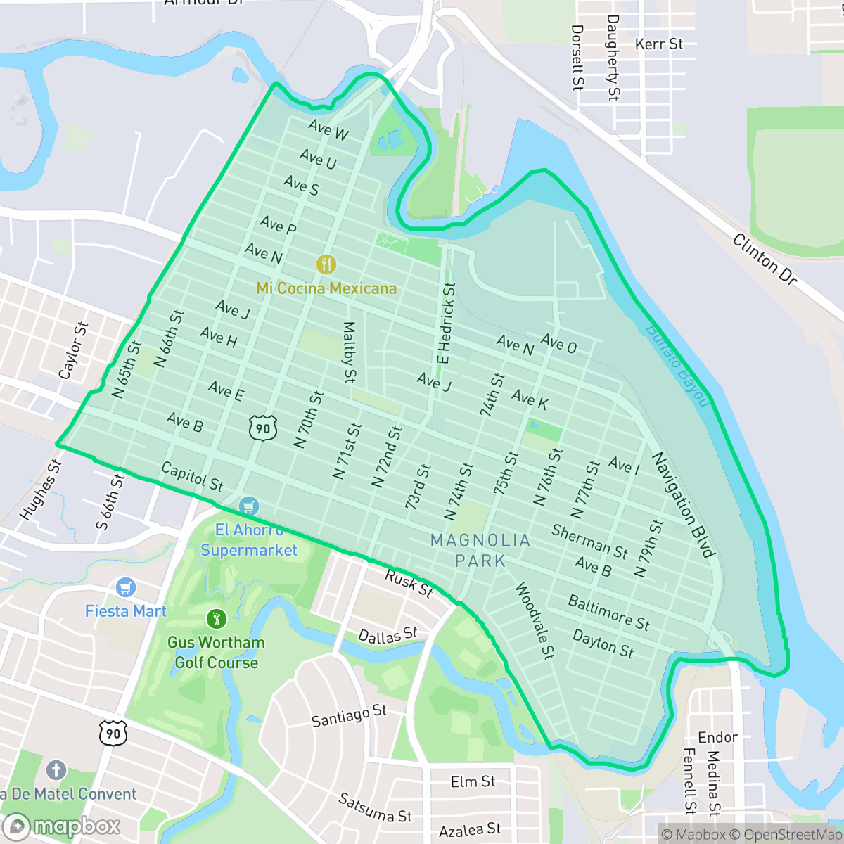
Magnolia Park is a historically significant, dense neighborhood in Houston known for its deep-rooted Hispanic culture and proximity to the Houston Ship Channel. While the area offers a traditional grid layout and diverse local dining, residents face challenges related to heavy industrial activity, limited green space, and significant noise from surrounding road and rail traffic.
Key Highlights
About Magnolia Park
Laid out in 1890 by Thomas M. Brady and named for its 3,750 planted magnolia trees, Magnolia Park was incorporated in 1913 before being annexed by Houston in 1926. It is one of Houston’s oldest Hispanic neighborhoods. Beginning in 1911, Mexican American laborers arrived to work on the Houston Ship Channel, initially settling in "El Arenal" (The Sands), an area built from dredged turning basin sand. Spurred by the Mexican Revolution, the community grew rapidly, becoming Houston's largest Mexican settlement by 1929, then known as "Little Mexico". Cultural preservation flourished through mutual aid societies and schools like Lorenzo De Zavala Elementary, which opened in 1926 as the city's first majority-Mexican-heritage school. The neighborhood's civic history is anchored by the 1923 Magnolia Park City Hall and Central Fire Station, a Recorded Texas Historic Landmark.
The neighborhood is a dense, low-rise urban environment defined by a mix of residential blocks and heavy industrial infrastructure. It maintains a strong community identity, supported by local institutions and a variety of authentic Mexican dining options that reflect its long history as a center for immigrant labor. The area is characterized by a high-density, grid-based layout where housing structures are closely packed, offering limited privacy and minimal yard space for residents.
Living in the area requires navigating several trade-offs, as it remains primarily car-dependent due to industrial barriers and inconsistent sidewalk infrastructure. Residents must contend with environmental concerns, including lower air quality and consistent noise levels from nearby rail lines and industrial facilities. While the neighborhood provides access to highly-rated local schools such as De Zavala Elementary and Edison Middle, the presence of large-scale storage tanks and logistics warehouses makes it a specific choice for those who prioritize proximity to the ship channel and established cultural roots over suburban tranquility.
Neighborhood Scores Across 15 Qualities
Residential structures are often closely packed with minimal side-yard buffers, resulting in less privacy than the Houston average. According to iHuus data, many blocks feature houses situated with very small gaps between neighbors.
Pedestrians may find sidewalks to be interrupted or missing in certain sections, though low traffic on residential streets allows for some walking. According to iHuus data, overall walkability is lower than the Houston average due to proximity to industrial zones and rail lines.
Residential views consist of high-density, simple structures and small lots that lack greenery or luxury amenities. This area appears significantly less visually diverse than the Houston average due to the presence of aging rooftops and proximity to heavy industrial zones.
Access to public parks and wide grassy verges is below the Houston average. Most greenery is confined to private fenced yards, though proximity to certain river-bend parklands and trails offers some outdoor opportunities for pets.
Land use consists of a dense blend of residential blocks, large-scale warehouses, and significant rail infrastructure. This landscape of industrial and utility zones is roughly in line with the city average.
A steady rhythm of local dining and social services exists alongside heavy industrial zones and railway lines. While the area offers more activity than the city average, the car-dependent layout makes navigating between destinations difficult without a vehicle.
Steady traffic sounds from nearby busy streets are present, though acoustic levels are relatively comparable to the Houston average according to iHuus data.
Frequent unhealthy air quality levels pose a significant risk to sensitive groups, with pollution levels recorded as worse than the Houston average according to iHuus data.
Industrial facilities and large-scale logistics hubs are present alongside residential areas, making the industrial presence noticeably lower than the Houston average. Residents may encounter heavy truck traffic, rail yards, and nearby warehouse operations interspersed with residential streets.
Health insurance coverage among residents is notably lower than the Houston average, according to iHuus data. This indicates a significant portion of the population lacks employer-sponsored or private medical coverage.
Political leanings in this area skew significantly more liberal than the Houston average, according to iHuus data.
Residents of all ages live here, ranging from young professionals to older adults. This demographic spread is largely consistent with the broader Houston area, according to iHuus data.
Residual flood risk exists within the area as it is located inside a 500 year floodplain. This level of safety is consistent with the average seen across Houston.
Block-Level Insights for Magnolia Park

iHuus Neighborhood Intelligence Insights
Get block-level neighborhood insights for Magnolia Park
- Street-level scores — see how individual blocks compare, not just neighborhood averages
- Micro-zone boundaries — identify quiet pockets, flood boundaries, and walkable clusters before you visit
- 15 dimensions in full — walkability, noise, air quality, school quality, insurance coverage, population age profile, urban/rural index, and more
- Boundary risk alerts — know if your address sits near a block boundary where scores drop, the kind of detail no listing will ever mention
- School insights — individual school ratings and insights, not just district-level data
- Compare before you commit — side-by-side data across neighborhoods, down to block precision
No credit card required
Compare with Any Neighborhood
| Dimension | Magnolia Park | Acres Home |
|---|---|---|
| 🚶 Walkabilityavg 7.08 | ||
| 🔊 Acoustic Comfortavg 4.14 | ||
| 🤫 Privacy Indexavg 5.34 | ||
| 🎨 Visual Appealavg 6.42 | ||
| 🐕 Dog Friendlinessavg 6.33 | ||
| 🗺️ Urban-Rural Indexavg 6.64 | ||
| ✨ Neighborhood Vibeavg 4.4 | ||
| 🏥 Health Insurance Coverageavg 5.46 | ||
| 🌿 Air Qualityavg 3.58 | ||
| 🏭 Industrial Proximityavg 6.9 | ||
| 🌊 Flood Safetyavg 6.27 | ||
| 🗳️ Ideological Leanavg 6.39 | ||
| 👥 Population Age Profileavg 4.6 | ||
| 🔥 Fire Safety | ||
| 🏫 School Quality |
Magnolia Park Rankings
School Districts Serving Magnolia Park
Houston ISD is a district in a state of extreme operational and political volatility, currently categorized by a state takeover and the loss of local community control. While the district maintains a collection of world-class magnet and high-performing schools that anchor its academic reputation, these are overshadowed by a 'Toxic' institutional environment characterized by a 33% teacher turnover rate, significant reliance on uncertified staff, and a steady 3.5% annual enrollment loss. Despite reports of rapid academic growth under the state-appointed leadership, the district's stability is undermined by intense community friction, school closures in underserved areas, and an organizational culture increasingly managed through high-stress compliance models, making it a high-risk entity for long-term consistency.
Schools
School Insights for Magnolia Park
Below average outcomes; significant attendance and academic challenges.
School Insights
See what's really behind every school rating near Magnolia Park
- Individual school ratings — each school's own score with outcome context, not just a district average
- Enrollment & class size data — student-to-teacher ratio and how it compares to the state average
- Full demographics breakdown — ethnicity and gender composition for every school in the enrollment zone
- Every school in the district — all schools within the enrollment boundary ranked by rating, not just the closest one
- Grade levels & benchmarks — elementary through high school, with below/above state-average flags
No credit card required