El Dorado - Oates Prairie, Houston
Updated · 3,798 residents
El Dorado - Oates Prairie is a quiet, industrial-suburban enclave in northeast Houston defined by its proximity to major logistics hubs and freight corridors. The area offers a low-density residential environment, though residents face significant challenges regarding air quality and limited local commercial amenities.
Key Highlights
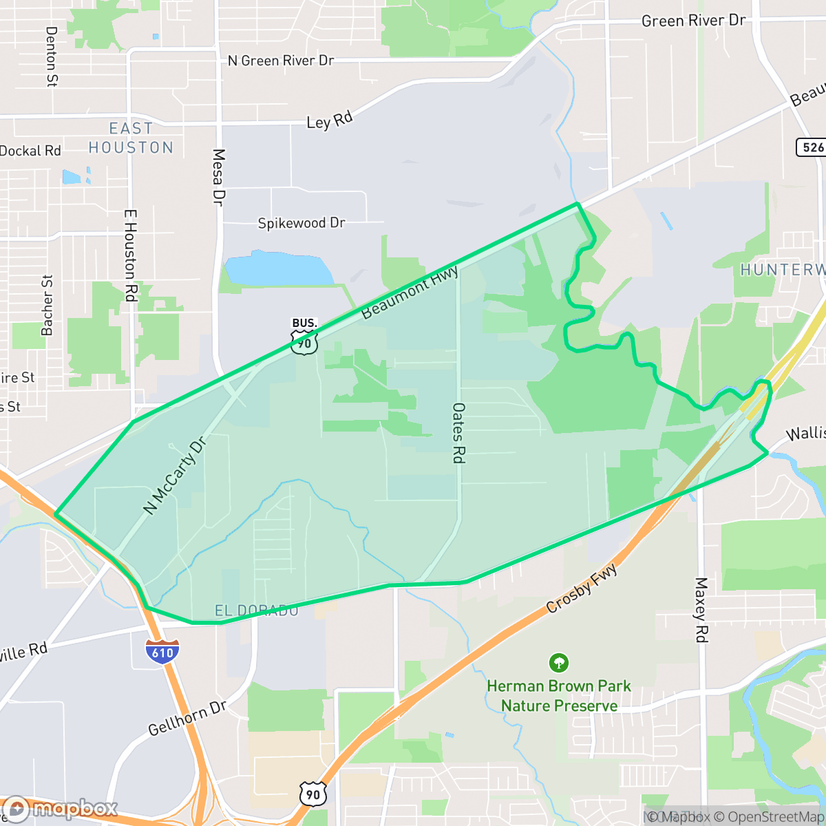
About El Dorado - Oates Prairie
Located in northeast Houston, El Dorado - Oates Prairie transitioned from 19th-century farmland into a working-class residential and industrial hub. The area’s history traces back to early Texas settler James Wyatt Oates, who arrived in the 1860s and established one of the state's first home-based schools. The historic Oates Prairie Cemetery (also known as Oates-Singleton Cemetery) serves as a resting place for early pioneers and Officer D. R. Patton, a casualty of the 1917 Camp Logan riot. Originally a rural settlement, Oates Prairie developed rapidly in the mid-20th century due to its proximity to Houston Ship Channel industries, prompting the construction of tract home subdivisions like El Dorado in the 1950s. Today, the neighborhood is characterized by a mix of ranch-style homes, industrial warehouses, and local landmarks like Oates Elementary School, which has served the community since 1937.
The area functions as a transition zone between established residential grids and heavy industrial infrastructure. It is characterized by a mix of ranch-style homes and sprawling warehouses that support the nearby Houston Ship Channel. The landscape is dominated by logistics facilities, rail lines, and scattered green space, creating a remote feel with minimal pedestrian infrastructure. According to current data, the neighborhood maintains a distinct industrial-suburban fringe aesthetic where residential blocks sit in close proximity to large-scale storage yards and transit corridors.
Daily life here is highly car-dependent, as local commercial options are sparse and limited to occasional fast-food or convenience spots. While the neighborhood maintains a relatively quiet atmosphere, the presence of heavy freight traffic and industrial operations contributes to persistent noise and air quality concerns. It is best suited for those prioritizing proximity to industrial employment centers over walkability or immediate access to retail and entertainment.
Neighborhood Scores Across 15 Qualities
Residential spacing provides a moderate buffer between neighbors, offering more seclusion than the typical Houston area. According to iHuus data, the neighborhood features a mix of densities that avoids the feeling of overcrowding.
Limited sidewalk infrastructure and high traffic volumes make pedestrian travel difficult. According to iHuus data, walkability in this area is significantly lower than the Houston average.
Standard tract housing with modest yard space defines the local landscape. This area features less visual variety than much of Houston, according to iHuus data.
Limited access to public parks and minimal green verges make this area less ideal for pet owners compared to the Houston average, according to iHuus data.
Open land and forested areas are more prevalent here than in most of Houston. Residents will find a landscape defined by scattered homes, significant woodland, and pockets of undeveloped space interspersed with industrial-suburban transitions.
Primarily characterized by industrial warehouses and freight corridors, this area offers very little commercial activity or social atmosphere. According to iHuus data, the lack of local businesses and dining options makes this neighborhood significantly less lively than the Houston average.
Frequent noise from nearby freight rail lines and major freeways makes this area louder than the Houston average. According to iHuus data, residents may experience consistent auditory disturbances from heavy transit corridors.
Frequent periods of unhealthy air quality pose significant risks to sensitive groups. According to iHuus data, these levels are notably worse than the Houston average.
Heavy industrial activity, including large-scale logistics warehouses, rail yards, and shipping container storage, is highly prevalent in this area. This significant concentration of freight traffic and distribution hubs is notably higher than the Houston average.
Health insurance accessibility is significantly lower than the Houston average, according to iHuus data. Residents may face limited access to employer-sponsored or private coverage within the area.
Political leanings in this area are predominantly liberal, representing a more progressive tilt than the Houston average according to iHuus data.
Residents will find a relatively balanced demographic spread of young adults, families, and seniors. According to iHuus data, this age distribution is slightly more varied than the average found across Houston.
Flood risk levels in this area are comparable to the Houston average, though a lack of detailed FEMA studies means the precise level of exposure remains undetermined. Residents should exercise caution as official flood maps for this specific location are not yet fully updated.
Address-Level Insights for El Dorado - Oates Prairie


iHuus Neighborhood Intelligence Insights
Get address-level neighborhood insights for El Dorado - Oates Prairie
- Street-level scores — see how individual blocks compare, not just neighborhood averages
- Micro-zone boundaries — identify quiet pockets, flood boundaries, and walkable clusters before you visit
- 15 dimensions in full — walkability, noise, air quality, school quality, insurance coverage, population age profile, urban/rural index, and more
- Boundary risk alerts — know if your address sits near a block boundary where scores drop, the kind of detail no listing will ever mention
- School insights — individual school ratings and insights, not just district-level data
- Compare before you commit — side-by-side data across neighborhoods, down to block precision
No credit card required
Compare with Any Neighborhood
| Dimension | El Dorado - Oates Prairie | Acres Home |
|---|---|---|
| 🚶 Walkabilityavg 7.08 | ||
| 🔊 Acoustic Comfortavg 4.14 | ||
| 🤫 Privacy Indexavg 5.34 | ||
| 🎨 Visual Appealavg 6.42 | ||
| 🐕 Dog Friendlinessavg 6.33 | ||
| 🗺️ Urban-Rural Indexavg 6.64 | ||
| ✨ Neighborhood Vibeavg 4.4 | ||
| 🏥 Health Insurance Coverageavg 5.46 | ||
| 🌿 Air Qualityavg 3.58 | ||
| 🏭 Industrial Proximityavg 6.9 | ||
| 🌊 Flood Safetyavg 6.27 | ||
| 🗳️ Ideological Leanavg 6.39 | ||
| 👥 Population Age Profileavg 4.6 | ||
| 🔥 Fire Safety | ||
| 🏫 School Quality |
El Dorado - Oates Prairie Rankings
School Districts Serving El Dorado - Oates Prairie
School Insights for El Dorado - Oates Prairie
Below average outcomes; significant attendance and academic challenges.
School Insights
See what's really behind every school rating near El Dorado - Oates Prairie
- Individual school ratings — each school's own score with outcome context, not just a district average
- Enrollment & class size data — student-to-teacher ratio and how it compares to the state average
- Full demographics breakdown — ethnicity and gender composition for every school in the enrollment zone
- Every school in the district — all schools within the enrollment boundary ranked by rating, not just the closest one
- Grade levels & benchmarks — elementary through high school, with below/above state-average flags
No credit card required