Carverdale, Houston
Updated June 22, 2026 · 5,437 residents
Carverdale is a quiet residential enclave in northwest Houston defined by its proximity to major industrial logistics hubs and highway corridors. While the neighborhood offers a low-density suburban atmosphere, residents should expect significant truck traffic and limited local amenities that necessitate regular vehicle use.
Key Highlights
About Carverdale
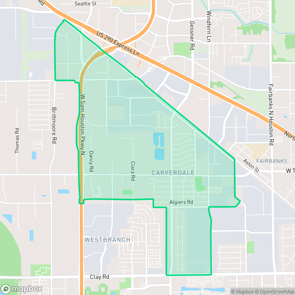
Located in northwest Houston, Carverdale originated in 1925 when a German dairy farmer donated a one-room farmhouse on Tanner Road to serve as both the Greater Macedonia Baptist Church and the first school for Black students in the area, then known as Independence Garden. The school eventually became the Fairbanks Colored School and later Carverdale School before closing due to desegregation mandates in 1970. Formally developed in the 1950s as a deed-restricted residential subdivision marketed to African Americans just outside the city limits, the neighborhood historically featured modest mid-century homes. Today, Carverdale is surrounded by major industrial and distribution complexes near Beltway 8 and US 290. Its community identity remains anchored by historic congregations like Greater Macedonia Baptist Church and local landmarks such as R.L. and Cora Johnson Park.
Located near the intersection of Beltway 8 and US 290, this area functions as a residential pocket surrounded by large-scale industrial and distribution infrastructure. The landscape is characterized by a mix of mid-century residential blocks and expansive warehouse zones, which create a distinct, industrial-adjacent environment. According to data, the area maintains a low-density feel, though the presence of major logistics centers results in consistent heavy truck traffic and industrial activity throughout the day. Residents benefit from proximity to major transit routes, which facilitates commuting across the Greater Houston region.
Living in the neighborhood requires personal transportation, as the area lacks high walkability and features few social or commercial destinations within immediate reach. Prospective residents will find a community that prioritizes access to major highways over pedestrian-friendly amenities. While the area provides essential services and local green spaces, its industrial proximity and ambient noise levels are notable trade-offs for those seeking a more traditional, quiet suburban lifestyle. It is best suited for individuals who prioritize affordability and highway connectivity over proximity to retail and dining.
Neighborhood Scores Across 15 Qualities
Residential spacing varies from larger older lots to closely packed townhomes, resulting in a level of privacy that is slightly lower than the Houston average according to iHuus data.
Residential streets are notably quiet and suitable for walking, though many blocks lack continuous sidewalks. This makes navigating the area on foot less convenient than the Houston average according to iHuus data.
Standard tract housing and higher-density units feature uniform rooflines and small yards. This level of visual variety is below the Houston average, according to iHuus data.
Public park access and usable green space for pets are below the Houston average. While some grass verges exist along residential streets, much of the neighborhood greenery is contained within private yards.
A landscape of residential pockets sits alongside large-scale warehouses and significant logistics infrastructure. According to iHuus data, this mix of industrial and suburban development is roughly in line with the typical urban-rural balance found across Houston.
Primarily industrial and suburban in character, this area lacks significant commercial density and offers much less social activity than the Houston average. Most essential services and dining options are scattered and require a vehicle to access.
Frequent noise from nearby railroad tracks and heavy freeway traffic is a notable feature of this area. According to iHuus data, acoustic comfort in Carverdale is lower than the Houston city average.
Air quality levels fluctuate between acceptable and unhealthy, presenting occasional concerns for sensitive groups. According to iHuus data, the air quality in Carverdale is slightly better than the Houston city average.
Logistics activity and heavy warehouse operations are significantly less prevalent here than in the rest of Houston. Residents can expect much less exposure to semi-truck traffic and industrial noise than the city average.
Health insurance coverage among residents is lower than the Houston average, according to iHuus data. This disparity may impact the ease of accessing preventative medical care within the community.
Political leanings within the area are divided, showing a more even split between conservative and liberal voters than the broader Houston average.
A balanced mix of young adults, families, and older residents characterizes the area. This demographic spread is slightly more varied than the average found across Houston, according to iHuus data.
Flood risk in this area is roughly in line with the Houston average, though official FEMA studies for the neighborhood remain incomplete. According to iHuus data, residents should remain aware of potential uncertainties regarding precise flood zone designations.
Block-Level Insights for Carverdale

iHuus Neighborhood Intelligence Insights
Get block-level neighborhood insights for Carverdale
- Street-level scores — see how individual blocks compare, not just neighborhood averages
- Micro-zone boundaries — identify quiet pockets, flood boundaries, and walkable clusters before you visit
- 15 dimensions in full — walkability, noise, air quality, school quality, insurance coverage, population age profile, urban/rural index, and more
- Boundary risk alerts — know if your address sits near a block boundary where scores drop, the kind of detail no listing will ever mention
- School insights — individual school ratings and insights, not just district-level data
- Compare before you commit — side-by-side data across neighborhoods, down to block precision
No credit card required
Compare with Any Neighborhood
| Dimension | Carverdale | Acres Home |
|---|---|---|
| 🚶 Walkabilityavg 7.08 | ||
| 🔊 Acoustic Comfortavg 4.14 | ||
| 🤫 Privacy Indexavg 5.34 | ||
| 🎨 Visual Appealavg 6.42 | ||
| 🐕 Dog Friendlinessavg 6.33 | ||
| 🗺️ Urban-Rural Indexavg 6.64 | ||
| ✨ Neighborhood Vibeavg 4.4 | ||
| 🏥 Health Insurance Coverageavg 5.46 | ||
| 🌿 Air Qualityavg 3.58 | ||
| 🏭 Industrial Proximityavg 6.9 | ||
| 🌊 Flood Safetyavg 6.27 | ||
| 🗳️ Ideological Leanavg 6.39 | ||
| 👥 Population Age Profileavg 4.6 | ||
| 🔥 Fire Safety | ||
| 🏫 School Quality |
Carverdale Rankings
School Districts Serving Carverdale
Cypress-Fairbanks ISD is a premier educational organization in the Greater Houston area, characterized by exceptional academic performance and a deep portfolio of high-performing schools. While the district maintains a significant number of 10/10 and 8/10 rated campuses and continues to outperform state STAAR averages, it is currently navigating fiscal challenges that have resulted in reduced transportation services and increased class sizes. Despite recent school board tensions and budgetary constraints, the district remains a 'Blue Chip' destination for families due to its elite high schools, robust CTE programs, and strong community engagement, though it falls just short of a 5 rating due to the current operational instability and loss of community trust regarding auxiliary services.
Schools
Spring Branch Independent School District is a high-performing but bifurcated organization currently operating under significant fiscal pressure. While its flagship 'terminal' high schools and southern elementary feeders maintain elite 10/10 rankings and robust community support, the district faces a widening achievement gap and operational strain due to Texas's 'recapture' system. Significant budget cuts, including the removal of campus librarians and increased participation fees for extracurriculars, have sparked local controversy and impacted teacher morale. Despite these challenges, SBISD remains a top-tier destination for many families due to its strong academic output and successful bond-funded facility improvements, though it currently sits in a transitional state between historical excellence and future financial uncertainty.
Schools
School Insights for Carverdale
Below average outcomes; significant attendance and academic challenges.
School Insights
See what's really behind every school rating near Carverdale
- Individual school ratings — each school's own score with outcome context, not just a district average
- Enrollment & class size data — student-to-teacher ratio and how it compares to the state average
- Full demographics breakdown — ethnicity and gender composition for every school in the enrollment zone
- Every school in the district — all schools within the enrollment boundary ranked by rating, not just the closest one
- Grade levels & benchmarks — elementary through high school, with below/above state-average flags
No credit card required