Alief, Houston
Updated · 124,824 residents
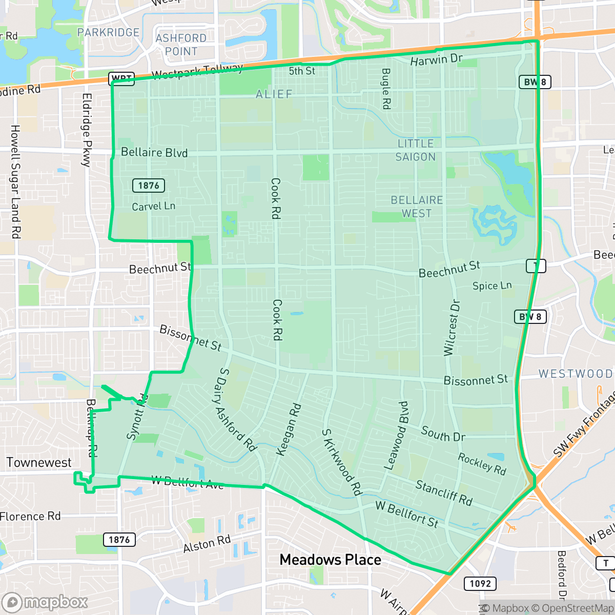
Alief is a dense, multicultural enclave in Houston known for its extensive sidewalk networks and accessible greenway trails. While the area features a high density of suburban housing and proximity to industrial zones, it offers residents a diverse culinary scene and well-connected pedestrian routes.
Key Highlights
About Alief
First settled in 1861 along Brays Bayou and platted in 1895, the Houston neighborhood of Alief was originally named Dairy. It was renamed Alief in honor of its first postmistress, Alief Ozelda Magee, to prevent postal confusion with Daisy, Texas. After the devastating 1900 Galveston hurricane destroyed local crops, the community rebounded by transforming its flood-prone prairies into a thriving hub for rice farming. This persistent flooding also prompted residents to establish the Harris County Flood Control District in 1909. Annexed by Houston in 1977, Alief evolved from a pastoral farming town into one of the city's most ethnically diverse international enclaves. Today, its multicultural character is anchored by landmarks like the historic Alief Cemetery, the Vietnamese Walk of Honor along Bellaire Boulevard, and its proximity to Houston’s vibrant Chinatown.
The area functions as a dense suburban landscape, characterized by a mix of single-family tract housing and multi-family apartment complexes. It maintains a relatively high level of walkability for a suburban environment, supported by consistent sidewalk coverage and dedicated off-street paths along central drainage corridors. These greenways serve as vital recreational spaces for residents, providing relief from the high-density residential layout where homes are often spaced closely together.
Prospective residents should note that the neighborhood is largely car-dependent despite its walkable street grid, as many commercial destinations require travel along major arterial roads. The area faces specific livability trade-offs, including lower-than-average flood safety ratings and proximity to industrial warehouse zones that contribute to road noise. However, the presence of several high-performing charter and public schools, combined with a vibrant international food culture, makes it a practical choice for families seeking a central location within the Greater Houston region.
Neighborhood Scores Across 15 Qualities
Residential spacing fluctuates between dense, shared-wall apartment complexes and detached homes with moderate setbacks. This layout offers slightly less privacy than the Houston average due to closely packed housing clusters and narrow side yards.
Extensive sidewalk networks and low-traffic residential streets provide safe pedestrian access that is better than the Houston average. While some major thoroughfares present crossing challenges, many areas feature continuous paths and dedicated greenery trails for easy movement.
A mix of mid-range tract housing and dense apartment complexes defines the landscape, featuring a visual profile that is slightly below the Houston average. While some pockets offer larger homes with private pools, much of the area is characterized by uniform rooflines and shared community amenities.
Extensive greenway trails and wide utility corridors provide ample off-street space for walking dogs. This access to connected green spaces is above the Houston average.
A varied landscape of single-family homes, apartment complexes, and commercial corridors characterizes the area. This level of development is consistent with the Houston average.
A diverse mix of dining and local services provides a balanced pace of life that is consistent with the city average. While some pockets offer walkable access to various eateries, many areas remain car-dependent due to a landscape of light industrial units and warehouse corridors.
Consistent noise from nearby busy thoroughfares is a common feature here, mirroring the typical acoustic levels found across Houston. According to iHuus data, residents can expect a moderate level of ambient sound from local vehicle movement.
Air quality levels fluctuate between acceptable and unhealthy conditions, though the air is slightly clearer than the Houston average according to iHuus data. Residents with respiratory sensitivities should monitor local conditions during periods of occasional concern.
Logistics hubs and large warehouses create pockets of significant truck traffic and noise. While many areas remain primarily residential, some sectors are located near a Superfund site and active utility infrastructure.
Health insurance coverage among residents is lower than the Houston average, according to iHuus data. This indicates a higher proportion of uninsured individuals within the community compared to most parts of the city.
Political leanings in Alief trend toward a liberal majority, which is slightly more progressive than the Houston city average according to iHuus data.
Residents live alongside a balanced spread of young adults, families, and older populations, mirroring the demographic distribution found across Houston.
Flood risk levels in this area remain uncertain because recent detailed studies have not been completed for this specific zone. According to iHuus data, the lack of definitive mapping suggests a higher level of uncertainty regarding flood safety compared to the Houston average.
Address-Level Insights for Alief


iHuus Neighborhood Intelligence Insights
Get address-level neighborhood insights for Alief
- Street-level scores — see how individual blocks compare, not just neighborhood averages
- Micro-zone boundaries — identify quiet pockets, flood boundaries, and walkable clusters before you visit
- 15 dimensions in full — walkability, noise, air quality, school quality, insurance coverage, population age profile, urban/rural index, and more
- Boundary risk alerts — know if your address sits near a block boundary where scores drop, the kind of detail no listing will ever mention
- School insights — individual school ratings and insights, not just district-level data
- Compare before you commit — side-by-side data across neighborhoods, down to block precision
No credit card required
Compare with Any Neighborhood
| Dimension | Alief | Acres Home |
|---|---|---|
| 🚶 Walkabilityavg 7.08 | ||
| 🔊 Acoustic Comfortavg 4.14 | ||
| 🤫 Privacy Indexavg 5.34 | ||
| 🎨 Visual Appealavg 6.42 | ||
| 🐕 Dog Friendlinessavg 6.33 | ||
| 🗺️ Urban-Rural Indexavg 6.64 | ||
| ✨ Neighborhood Vibeavg 4.4 | ||
| 🏥 Health Insurance Coverageavg 5.46 | ||
| 🌿 Air Qualityavg 3.58 | ||
| 🏭 Industrial Proximityavg 6.9 | ||
| 🌊 Flood Safetyavg 6.27 | ||
| 🗳️ Ideological Leanavg 6.39 | ||
| 👥 Population Age Profileavg 4.6 | ||
| 🔥 Fire Safety | ||
| 🏫 School Quality |
Alief Rankings
School Districts Serving Alief
School Insights for Alief
Below average outcomes; significant attendance and academic challenges.
School Insights
See what's really behind every school rating near Alief
- Individual school ratings — each school's own score with outcome context, not just a district average
- Enrollment & class size data — student-to-teacher ratio and how it compares to the state average
- Full demographics breakdown — ethnicity and gender composition for every school in the enrollment zone
- Every school in the district — all schools within the enrollment boundary ranked by rating, not just the closest one
- Grade levels & benchmarks — elementary through high school, with below/above state-average flags
No credit card required