Rim Area, El Paso
Updated June 22, 2026 · 1,385 residents
The Rim Area is defined by its dramatic elevation and architectural diversity, offering residents quiet streets and excellent air quality. While it is a car-oriented neighborhood with limited walkability, its proximity to green spaces makes it a highly dog-friendly environment for those seeking a peaceful residential setting.
Key Highlights
About Rim Area
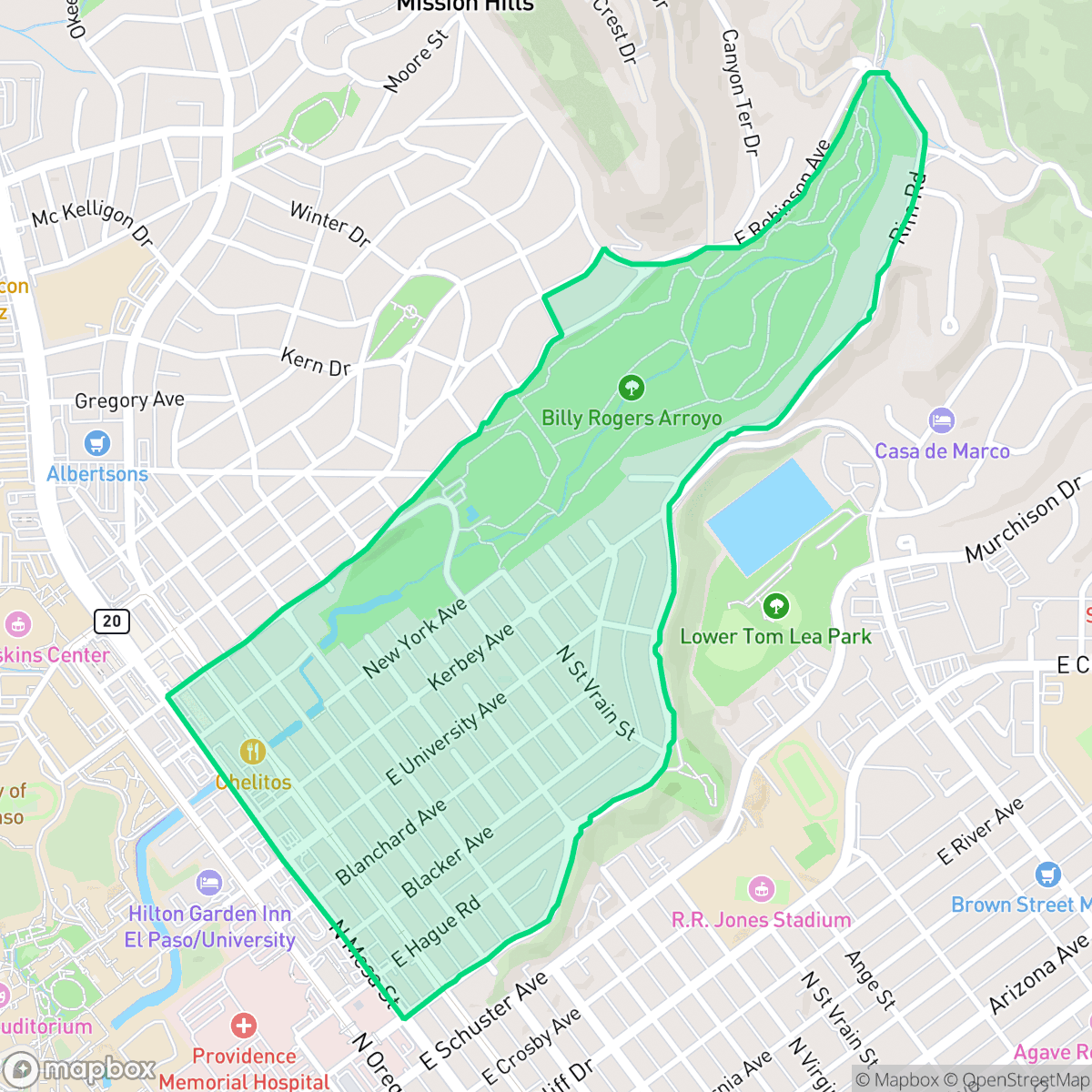
Perched on a mesa overlooking central El Paso and Ciudad Juárez, the historic Rim Area neighborhood—originally known as La Mesa—served in its early days as a lime-delivery train route. In the early 1900s, part of the area became "Stormsville," a settlement founded by attorney D. Storms to house refugees of the 1897 Rio Grande flood. The area also witnessed a skirmish during the Mexican Revolution before modern development began in 1928 with the platting of the Rim Road Development Corporation. Today, the neighborhood is defined by its dramatic views along Rim Road and Scenic Drive, and its proximity to Tom Lea Park. Its diverse architectural landscape features Craftsman, Spanish Colonial, and territorial homes designed by prominent local architects, including Henry Trost, Otto Thormon, and Mabel Welch.
The neighborhood offers a serene residential atmosphere characterized by high acoustic comfort and exceptional air quality, according to iHuus data. Its elevated position provides residents with significant visual appeal, while the low-density layout ensures a private living experience compared to other parts of El Paso. The area is particularly well-suited for dog owners who value access to quiet, open spaces like the Billy Rogers Arroyo.
Prospective residents should be aware that the area is primarily car-dependent, with few daily amenities within walking distance. While the location offers a distinct lifestyle, it carries a higher risk for flood-related concerns. Families should also consider the broader El Paso Independent School District, which presents a mix of high-achieving magnet programs alongside campuses currently navigating structural and budgetary transitions.
Neighborhood Scores Across 15 Qualities
Residential structures are often closely spaced with shared property lines, providing a level of privacy that is consistent with the El Paso average.
Pedestrian access is generally reliable due to a consistent grid and sidewalks, though some routes lack shade and border high-traffic roads. This level of walkability is higher than the El Paso average according to iHuus data.
Standard tract housing and multi-unit complexes define the landscape, featuring consistent architectural lines and tidy yards. This visual profile is roughly in line with the typical aesthetic found across El Paso.
Limited green verges and a prevalence of pavement make finding shaded walking areas difficult. According to iHuus data, the neighborhood offers slightly more access to parkland than the El Paso average, though the arid environment remains a factor for pet owners.
A balance of street density and green space defines this area, which feels slightly more urban than the El Paso average. Certain pockets feature a dense, low-rise grid with large institutional buildings and limited vegetation, according to iHuus data.
Varied pockets of activity range from quiet, rural landscapes to lively blocks with accessible dining and parks. According to iHuus data, the area offers a more active social atmosphere than the El Paso average, though many sections remain car-dependent.
Steady noise from nearby busy streets creates a constant hum, though acoustic comfort levels remain higher than the El Paso average. According to iHuus data, this level of activity is typical for a central transit area.
Air quality in this area remains consistently high with minimal health concerns. According to iHuus data, these levels are superior to the average found throughout El Paso.
Industrial activity is virtually nonexistent here, with the area consisting primarily of residential, institutional, and light commercial uses. This lack of warehouses or heavy manufacturing makes the neighborhood significantly cleaner of industrial encroachment than the El Paso average.
Health insurance access is significantly higher than the El Paso city average, providing residents with greater access to medical services. According to iHuus data, a substantial portion of the population maintains coverage.
Voting patterns and census indicators show a predominantly liberal political leaning, which is more pronounced here than in the El Paso city average.
Residents live alongside a balanced mix of young adults, families, and seniors. This demographic distribution is slightly more varied than the average found throughout El Paso.
Properties in this area are located within a designated floodplain, which may necessitate flood insurance. According to iHuus data, the level of flood risk in the Rim Area is higher than the El Paso city average.
Block-Level Insights for Rim Area

iHuus Neighborhood Intelligence Insights
Get block-level neighborhood insights for Rim Area
- Street-level scores — see how individual blocks compare, not just neighborhood averages
- Micro-zone boundaries — identify quiet pockets, flood boundaries, and walkable clusters before you visit
- 15 dimensions in full — walkability, noise, air quality, school quality, insurance coverage, population age profile, urban/rural index, and more
- Boundary risk alerts — know if your address sits near a block boundary where scores drop, the kind of detail no listing will ever mention
- School insights — individual school ratings and insights, not just district-level data
- Compare before you commit — side-by-side data across neighborhoods, down to block precision
No credit card required
Compare with Any Neighborhood
| Dimension | Rim Area | A Presidential Neighborhood |
|---|---|---|
| 🚶 Walkabilityavg 6.43 | ||
| 🔊 Acoustic Comfortavg 3.42 | ||
| 🤫 Privacy Indexavg 5.26 | ||
| 🎨 Visual Appealavg 5.76 | ||
| 🐕 Dog Friendlinessavg 4.74 | ||
| 🗺️ Urban-Rural Indexavg 6.67 | ||
| ✨ Neighborhood Vibeavg 4.56 | ||
| 🏥 Health Insurance Coverageavg 4.91 | ||
| 🌿 Air Qualityavg 9.4 | ||
| 🏭 Industrial Proximityavg 7.86 | ||
| 🌊 Flood Safetyavg 3.36 | ||
| 🗳️ Ideological Leanavg 8 | ||
| 👥 Population Age Profileavg 4.76 | ||
| 🔥 Fire Safety | ||
| 🏫 School Quality |
Rim Area Rankings
School Districts Serving Rim Area
El Paso Independent School District is currently in a state of high-stakes transition, characterized by a sharp performance gap between its premier magnet programs and struggling neighborhood schools. While the district maintains several 10/10-rated 'Blue Chip' campuses and celebrates successes in fine arts and college readiness, it is grappling with significant structural headwinds including a multi-million dollar budget deficit, declining student enrollment, and the contentious 'Destination EPISD' school closure plan. Operational stability is hampered by teacher morale concerns and administrative friction, though strong extracurricular pipelines and improving graduation rates provide a foundation of academic resilience. The district remains a viable but polarized choice, requiring parents to navigate between elite specialized 'pockets' and campuses currently under consolidation pressure.
Schools
School Insights for Rim Area
Below average outcomes; significant attendance and academic challenges.
School Insights
See what's really behind every school rating near Rim Area
- Individual school ratings — each school's own score with outcome context, not just a district average
- Enrollment & class size data — student-to-teacher ratio and how it compares to the state average
- Full demographics breakdown — ethnicity and gender composition for every school in the enrollment zone
- Every school in the district — all schools within the enrollment boundary ranked by rating, not just the closest one
- Grade levels & benchmarks — elementary through high school, with below/above state-average flags
No credit card required