El Paso Lower Valley, El Paso
Updated · 5,625 residents
The El Paso Lower Valley is a dense residential community characterized by its long-standing cultural roots and proximity to major industrial corridors. While the area offers access to highly-regarded schools within the Ysleta Independent School District, residents should expect notable noise levels from nearby highway traffic and a lack of privacy due to the tightly packed housing layout.
Key Highlights
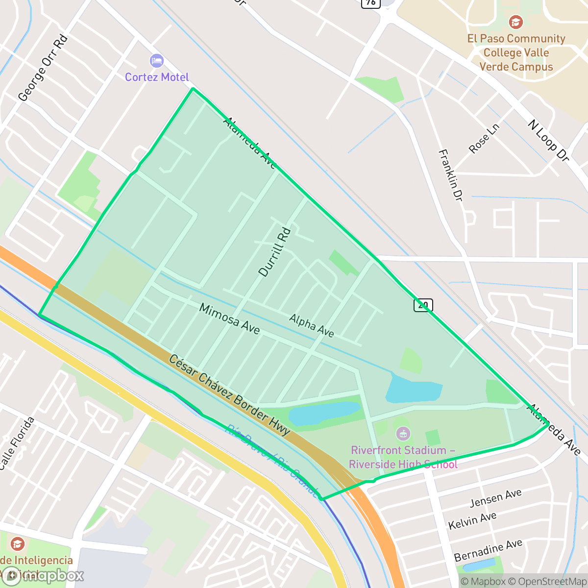
About El Paso Lower Valley
El Paso’s Lower Valley, also known as the Mission Valley, is one of the oldest continuously inhabited areas in the region, tracing its roots to the late 17th century. Following the 1680 Pueblo Revolt in New Mexico, Spanish settlers and Tigua Indian refugees fled south, establishing permanent agricultural settlements along the Rio Grande. This era birthed the historic Mission Trail, which features the Ysleta Mission (founded in 1682 and recognized as the oldest continuously operating parish in Texas) and the Socorro Mission. The neighborhood is also home to the Ysleta del Sur Pueblo, a federally recognized Native American tribe. Historically defined by its fertile agricultural land, the Lower Valley transitioned into a suburban-urban community in the mid-20th century. Today, landmarks like Ascarate Park and local institutions like Valentine's Bakery preserve its deep-seated cultural heritage.
This neighborhood serves as a dense suburban environment where residential blocks are often situated near industrial warehouses and major transportation routes. According to iHuus data, the community is anchored by the Ysleta Independent School District, which provides residents with access to high-performing campuses such as Riverside High School. The area maintains a calm, suburban atmosphere, punctuated by public green spaces like Vocational Pond Park and local institutions that support community life.
Prospective residents should weigh the academic benefits against certain environmental trade-offs. The area experiences significant noise from road traffic, and the residential landscape is marked by high density with limited privacy between homes. Additionally, the lack of extensive sidewalk infrastructure and low flood safety ratings are important considerations for those evaluating the long-term livability of the area. It is best suited for families prioritizing access to top-tier local schools who are comfortable with a standard suburban setting.
Neighborhood Scores Across 15 Qualities
Residential spacing is somewhat tight, with many homes situated very close to one another or sharing walls. This level of density is slightly higher than the average found throughout El Paso.
Pedestrians must often use road shoulders or dirt edges due to a lack of sidewalks on many residential streets. While internal neighborhood paths offer some connectivity, overall walkability is lower than the El Paso average.
Dense housing layouts and unpaved lots contribute to a landscape that is less visually polished than the El Paso average. Many areas feature small yards and minimal greenery, which may feel more industrial or distressed to some observers.
Public parks and open school fields offer accessible spaces for pets, though residential street verges are generally narrow and arid. According to iHuus data, the availability of green space and nearby dry riverbed paths makes this area slightly more dog friendly than the El Paso average.
Open lots and industrial rail yards are interspersed with low-density residential blocks, resulting in a landscape that is slightly more rural than the El Paso average. According to iHuus data, the area features a blend of suburban grids and significant industrial logistics zones.
A mix of industrial warehouses and suburban streets creates a steady but subdued atmosphere that is largely comparable to the city average. While local dining and parks are accessible, the area's layout remains heavily car-dependent according to iHuus data.
Frequent auditory disturbances from nearby railroad tracks and heavy freeway traffic are common in this area. According to iHuus data, acoustic comfort in this neighborhood is notably lower than the El Paso city average.
Air quality remains consistently high with minimal health concerns for residents. While the levels are excellent, they are slightly below the El Paso city average according to iHuus data.
Residential sectors are interspersed with large warehouses, active rail yards, and logistics hubs. According to iHuus data, this concentration of commercial trucking and rail activity is higher than the El Paso city average.
Health insurance coverage is notably lower than the El Paso city average. According to iHuus data, a small portion of the resident population is covered by health insurance plans.
Voting patterns and census indicators show a stronger liberal leaning here than the average found across El Paso. According to iHuus data, the area's political landscape is notably more progressive than the city-wide norm.
Residents live alongside a balanced mix of young adults, families, and seniors. According to iHuus data, the age distribution is slightly more varied than the El Paso average.
Flood risk in this area is significantly higher than the El Paso average. Residents should prepare for elevated flood hazards and potentially higher insurance premiums, according to iHuus data.
Address-Level Insights for El Paso Lower Valley


iHuus Neighborhood Intelligence Insights
Get address-level neighborhood insights for El Paso Lower Valley
- Street-level scores — see how individual blocks compare, not just neighborhood averages
- Micro-zone boundaries — identify quiet pockets, flood boundaries, and walkable clusters before you visit
- 15 dimensions in full — walkability, noise, air quality, school quality, insurance coverage, population age profile, urban/rural index, and more
- Boundary risk alerts — know if your address sits near a block boundary where scores drop, the kind of detail no listing will ever mention
- School insights — individual school ratings and insights, not just district-level data
- Compare before you commit — side-by-side data across neighborhoods, down to block precision
No credit card required
Compare with Any Neighborhood
| Dimension | El Paso Lower Valley | A Presidential Neighborhood |
|---|---|---|
| 🚶 Walkabilityavg 6.43 | ||
| 🔊 Acoustic Comfortavg 3.42 | ||
| 🤫 Privacy Indexavg 5.26 | ||
| 🎨 Visual Appealavg 5.76 | ||
| 🐕 Dog Friendlinessavg 4.74 | ||
| 🗺️ Urban-Rural Indexavg 6.67 | ||
| ✨ Neighborhood Vibeavg 4.56 | ||
| 🏥 Health Insurance Coverageavg 4.91 | ||
| 🌿 Air Qualityavg 9.4 | ||
| 🏭 Industrial Proximityavg 7.86 | ||
| 🌊 Flood Safetyavg 3.36 | ||
| 🗳️ Ideological Leanavg 8 | ||
| 👥 Population Age Profileavg 4.76 | ||
| 🔥 Fire Safety | ||
| 🏫 School Quality |
El Paso Lower Valley Rankings
School Districts Serving El Paso Lower Valley
School Insights for El Paso Lower Valley
Below average outcomes; significant attendance and academic challenges.
School Insights
See what's really behind every school rating near El Paso Lower Valley
- Individual school ratings — each school's own score with outcome context, not just a district average
- Enrollment & class size data — student-to-teacher ratio and how it compares to the state average
- Full demographics breakdown — ethnicity and gender composition for every school in the enrollment zone
- Every school in the district — all schools within the enrollment boundary ranked by rating, not just the closest one
- Grade levels & benchmarks — elementary through high school, with below/above state-average flags
No credit card required