North Andrews Gardens, Oakland Park
Updated · 8,035 residents
North Andrews Gardens is a residential community defined by its mid-century suburban layout and uniform single-family homes. While it offers a stable, balanced atmosphere for residents, the area experiences significant noise from nearby transit corridors and limited access to public green spaces.
Key Highlights
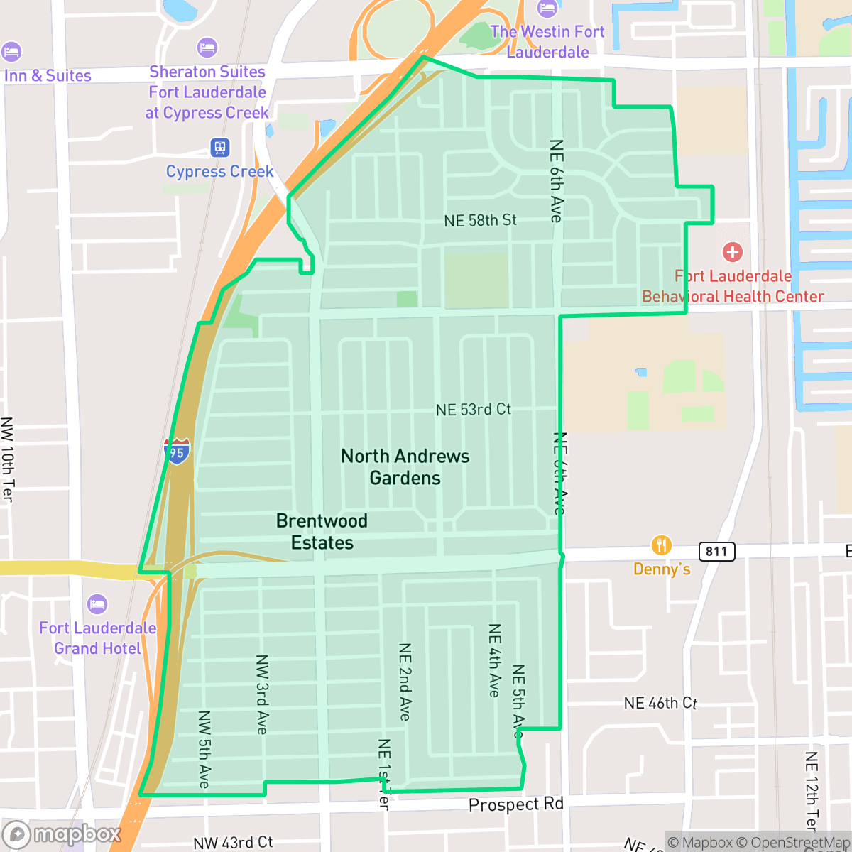
About North Andrews Gardens
North Andrews Gardens emerged in the early 1950s as a planned residential development, reflecting the post-World War II suburban expansion across South Florida. Developed by the Prosperity Development Corp. of Florida, the community was aggressively marketed as one of the region's fastest-selling sites, designed to provide affordable housing for returning veterans and migrating families. The neighborhood is characterized by its mid-century architectural stock and a compact, well-organized layout. Originally an unincorporated census-designated place, North Andrews Gardens maintained a distinct identity for decades before being annexed by the city of Oakland Park in 2005. Today, it remains a stable residential enclave that bridges the gap between the urban density of Fort Lauderdale and the suburban character of northern Broward County.
The neighborhood features a consistent suburban rhythm, characterized by a grid of single-family homes that reflect its mid-century origins. It maintains a moderate level of privacy and a diverse age mix, providing a familiar setting for families, young professionals, and retirees alike. According to iHuus data, the area is well-positioned for those who value a straightforward, predictable residential environment within the broader Oakland Park landscape. Residents benefit from a steady mix of local eateries and transit access that supports a functional daily routine.
Prospective residents should consider the trade-offs associated with this location. The proximity to major transit routes and rail lines results in elevated ambient noise levels, which may impact acoustic comfort. Additionally, the neighborhood has limited public park access and faces challenges with air quality that fluctuate with local weather patterns. While it offers a moderate level of walkability, the presence of major infrastructure barriers can make navigating the area on foot more difficult than in other parts of the city.
Neighborhood Scores Across 15 Qualities
Residential spacing provides a moderate level of separation between neighbors, consistent with the city average. While some areas feature tightly clustered structures, others offer more distinct buffers between homes.
Quiet residential streets allow for easy walking, though the presence of a major highway and rail corridor creates significant barriers for pedestrians. This level of accessibility is slightly below the Oakland Park average according to iHuus data.
Standard tract housing with small yards and uniform rooflines defines the area. According to iHuus data, this level of visual variety is slightly below the Oakland Park average.
Public walking areas and park access are sparse in this neighborhood, trailing the city average. Most greenery is restricted to private fenced backyards or narrow street verges.
Developed suburban blocks and commercial corridors define this area, matching the broader city pattern of dense residential and light industrial use. According to iHuus data, the landscape consists primarily of single-family homes and managed complexes rather than open countryside.
A consistent mix of dining, transit hubs, and residential life creates an energy level that is typical for the city. Residents can access a reliable variety of local eateries and parks within a balanced urban setting.
Frequent acoustic disruptions from nearby major transit corridors and flight paths characterize this area. According to iHuus data, the level of ambient noise is notably higher than the Oakland Park average.
Air quality in this area fluctuates between acceptable and unhealthy levels. According to iHuus data, the air quality mirrors the city average, meaning residents may experience occasional concerns during certain weather patterns.
Nearby commercial activities and an adjacent EPA Superfund site contribute to a higher presence of light industrial utility than seen in most of Oakland Park. Residents may encounter increased transit traffic, heavy freight movement from nearby storage facilities, and potential environmental concerns regarding soil or groundwater contamination.
Health insurance accessibility is slightly lower than the Oakland Park average, according to iHuus data. Residents may find fewer options for coverage within the immediate area compared to the broader city.
Political leanings in this area trend liberal, though the community is less overwhelmingly progressive than the Oakland Park average according to iHuus data.
Residents live in an area with a diverse age distribution, featuring a comparable mix of young adults, families, and seniors when compared to the Oakland Park average.
Flood risk in this area remains difficult to assess because FEMA has not yet finished a detailed study for the neighborhood. According to iHuus data, the level of risk is roughly comparable to the average seen across Oakland Park.
Address-Level Insights for North Andrews Gardens


iHuus Neighborhood Intelligence Insights
Get address-level neighborhood insights for North Andrews Gardens
- Street-level scores — see how individual blocks compare, not just neighborhood averages
- Micro-zone boundaries — identify quiet pockets, flood boundaries, and walkable clusters before you visit
- 15 dimensions in full — walkability, noise, air quality, school quality, insurance coverage, population age profile, urban/rural index, and more
- Boundary risk alerts — know if your address sits near a block boundary where scores drop, the kind of detail no listing will ever mention
- School insights — individual school ratings and insights, not just district-level data
- Compare before you commit — side-by-side data across neighborhoods, down to block precision
No credit card required
Compare with Any Neighborhood
| Dimension | North Andrews Gardens | Andrews Gardens |
|---|---|---|
| 🚶 Walkabilityavg 6.86 | ||
| 🔊 Acoustic Comfortavg 3.24 | ||
| 🤫 Privacy Indexavg 5.54 | ||
| 🎨 Visual Appealavg 6.36 | ||
| 🐕 Dog Friendlinessavg 5.18 | ||
| 🗺️ Urban-Rural Indexavg 6.55 | ||
| ✨ Neighborhood Vibeavg 4.88 | ||
| 🏥 Health Insurance Coverageavg 5.61 | ||
| 🌿 Air Qualityavg 6.04 | ||
| 🏭 Industrial Proximityavg 6.08 | ||
| 🌊 Flood Safetyavg 3.7 | ||
| 🗳️ Ideological Leanavg 8.11 | ||
| 👥 Population Age Profileavg 5.13 | ||
| 🔥 Fire Safety | ||
| 🏫 School Quality |
North Andrews Gardens Rankings
School Districts Serving North Andrews Gardens
School Insights for North Andrews Gardens
Below average outcomes; significant attendance and academic challenges.
School Insights
See what's really behind every school rating near North Andrews Gardens
- Individual school ratings — each school's own score with outcome context, not just a district average
- Enrollment & class size data — student-to-teacher ratio and how it compares to the state average
- Full demographics breakdown — ethnicity and gender composition for every school in the enrollment zone
- Every school in the district — all schools within the enrollment boundary ranked by rating, not just the closest one
- Grade levels & benchmarks — elementary through high school, with below/above state-average flags
No credit card required