Upper Eastside, Miami
Updated · 13,811 residents
The Upper Eastside is defined by its historic Miami Modern architecture and quiet, residential subdivisions along the Biscayne corridor. While the area offers a suburban feel with diverse housing, residents should expect notable traffic noise and limited access to public green spaces.
Key Highlights
About Upper Eastside
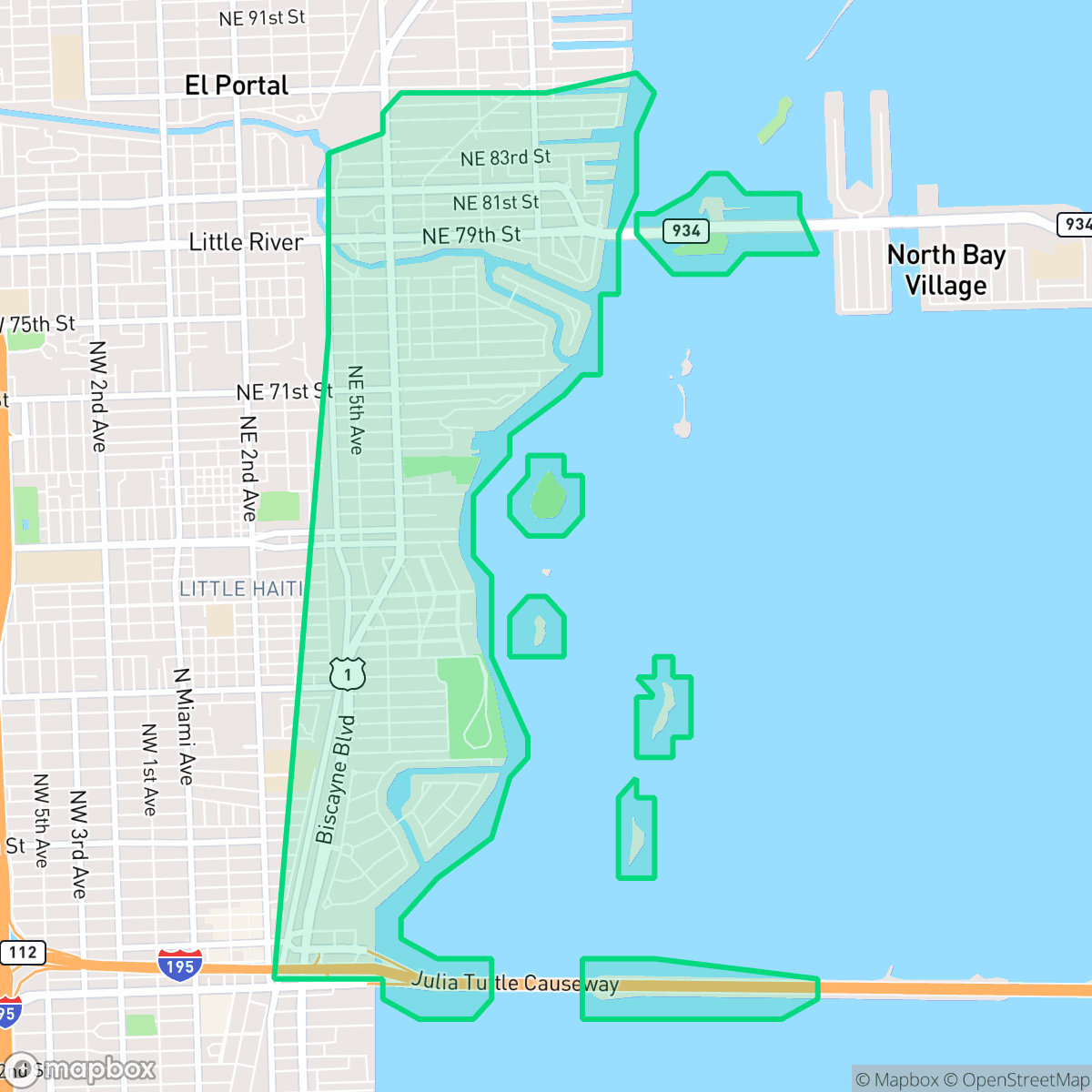
The Upper Eastside of Miami, settled in 1909 and annexed by the city in 1924, is defined by its diverse residential subdivisions, including Morningside, Bay Point, and Belle Meade. The neighborhood is anchored by the MiMo Biscayne Boulevard Historic District, a 27-block corridor celebrated for its post-World War II 'Miami Modern' (MiMo) architecture. This style, characterized by curved lines, decorative breeze blocks, and an optimistic tropical aesthetic, is exemplified by restored landmarks like the Vagabond Hotel and the iconic Coppertone sign. While the area faced urban decay in the 1980s, it has since undergone a significant cultural and architectural renaissance. Today, it balances historic residential enclaves—featuring Mediterranean Revival and Art Deco homes—with a vibrant commercial strip of boutiques, galleries, and adaptive-reuse projects like the creative district Miami Ironside.
The neighborhood functions as a suburban-leaning enclave that balances quiet residential streets with a visible commercial presence. Residents enjoy a mix of architectural styles and a balanced age demographic that includes young professionals and seniors. While the area maintains a subdued atmosphere, the proximity to major transit corridors introduces frequent traffic noise and occasional air quality challenges. According to iHuus data, the area is characterized by a suburban layout that integrates light industrial zones with established neighborhoods, creating a distinct, if sometimes inconsistent, visual and functional landscape. Prospective residents should consider the trade-offs associated with living in this part of Miami. The community faces significant flood vulnerability, and access to large, communal public parks remains limited. While the Dade County School District serves the area, families should be aware of the performance gap between elite magnet programs and local neighborhood schools, as well as the district's ongoing budgetary transitions. Additionally, health insurance coverage rates in the area are lower than the city average, which is a factor for some households to consider.
Neighborhood Scores Across 15 Qualities
Building proximity and lot sizes vary significantly across the area, ranging from dense apartment clusters to single-family homes with modest buffers. This level of density aligns with the city average for Miami.
Quiet residential streets and established tree canopies facilitate easy movement, though high-traffic corridors and industrial zones occasionally create barriers. Pedestrian accessibility is lower than the Miami average due to inconsistent sidewalk networks in certain sections of the area.
Visual variety ranges from high-end waterfront estates with private docks to dense, functional tract housing. According to iHuus data, the overall scenery is roughly comparable to the city average.
Access to large public parks and wide green verges for walking is slightly below the city average. While some areas feature waterfront trails and residential greenery, much of the neighborhood consists of narrow sidewalks and private yards with limited communal park access.
Residential blocks and commercial warehouses exist in a balanced suburban layout. This environment is slightly more suburban than the typical Miami urban landscape, featuring a combination of single-family homes and light industrial zones according to iHuus data.
Activity levels in this area are generally lower than the Miami average. While some pockets feature bustling commercial hubs and diverse dining, much of the neighborhood remains subdued or characterized by quiet, residential streets.
Frequent noise from nearby major thoroughfares and transit paths characterizes this area. According to iHuus data, acoustic comfort levels are slightly below the city average.
Frequent unhealthy air quality levels pose a significant risk to sensitive groups; according to iHuus data, conditions in this area are worse than the Miami average.
Light industrial and commercial activity, including warehouses and transit corridors, exists alongside residential areas at levels similar to the city average. Residents may encounter occasional heavy traffic or utility-related odors near specific commercial zones, though heavy manufacturing is absent.
Health insurance access for residents is lower than the Miami average. According to iHuus data, a significant portion of the local population lacks coverage.
Political leanings in this area favor liberal ideologies, which is more pronounced than the average seen across Miami.
Residents inhabit a community with a varied age distribution, though the population leans slightly more toward older demographics than the Miami average. According to iHuus data, this creates a balanced environment of young adults, families, and seniors.
Frequent flood vulnerability exists because much of the area sits within a designated floodplain. According to iHuus data, this risk level is higher than the average for Miami.
Address-Level Insights for Upper Eastside


iHuus Neighborhood Intelligence Insights
Get address-level neighborhood insights for Upper Eastside
- Street-level scores — see how individual blocks compare, not just neighborhood averages
- Micro-zone boundaries — identify quiet pockets, flood boundaries, and walkable clusters before you visit
- 15 dimensions in full — walkability, noise, air quality, school quality, insurance coverage, population age profile, urban/rural index, and more
- Boundary risk alerts — know if your address sits near a block boundary where scores drop, the kind of detail no listing will ever mention
- School insights — individual school ratings and insights, not just district-level data
- Compare before you commit — side-by-side data across neighborhoods, down to block precision
No credit card required
Compare with Any Neighborhood
| Dimension | Upper Eastside | Alameda - West Flagler |
|---|---|---|
| 🚶 Walkabilityavg 6.81 | ||
| 🔊 Acoustic Comfortavg 3.72 | ||
| 🤫 Privacy Indexavg 4.25 | ||
| 🎨 Visual Appealavg 6.05 | ||
| 🐕 Dog Friendlinessavg 4.71 | ||
| 🗺️ Urban-Rural Indexavg 5.07 | ||
| ✨ Neighborhood Vibeavg 4.83 | ||
| 🏥 Health Insurance Coverageavg 4.76 | ||
| 🌿 Air Qualityavg 3.78 | ||
| 🏭 Industrial Proximityavg 6.31 | ||
| 🌊 Flood Safetyavg 3.97 | ||
| 🗳️ Ideological Leanavg 4.66 | ||
| 👥 Population Age Profileavg 4.38 | ||
| 🔥 Fire Safety | ||
| 🏫 School Quality |
Upper Eastside Rankings
School Districts Serving Upper Eastside
School Insights for Upper Eastside
Below average outcomes; significant attendance and academic challenges.
School Insights
See what's really behind every school rating near Upper Eastside
- Individual school ratings — each school's own score with outcome context, not just a district average
- Enrollment & class size data — student-to-teacher ratio and how it compares to the state average
- Full demographics breakdown — ethnicity and gender composition for every school in the enrollment zone
- Every school in the district — all schools within the enrollment boundary ranked by rating, not just the closest one
- Grade levels & benchmarks — elementary through high school, with below/above state-average flags
No credit card required