Durrs Homeowners, Fort Lauderdale
Updated · 2,837 residents
Durrs Homeowners is a residential community centered on the historic Sistrunk Boulevard, known for its deep roots in Fort Lauderdale's African American heritage. The area features a standard suburban layout with quiet streets, though residents should be aware of high noise levels from nearby transit and a notable risk of flooding.
Key Highlights
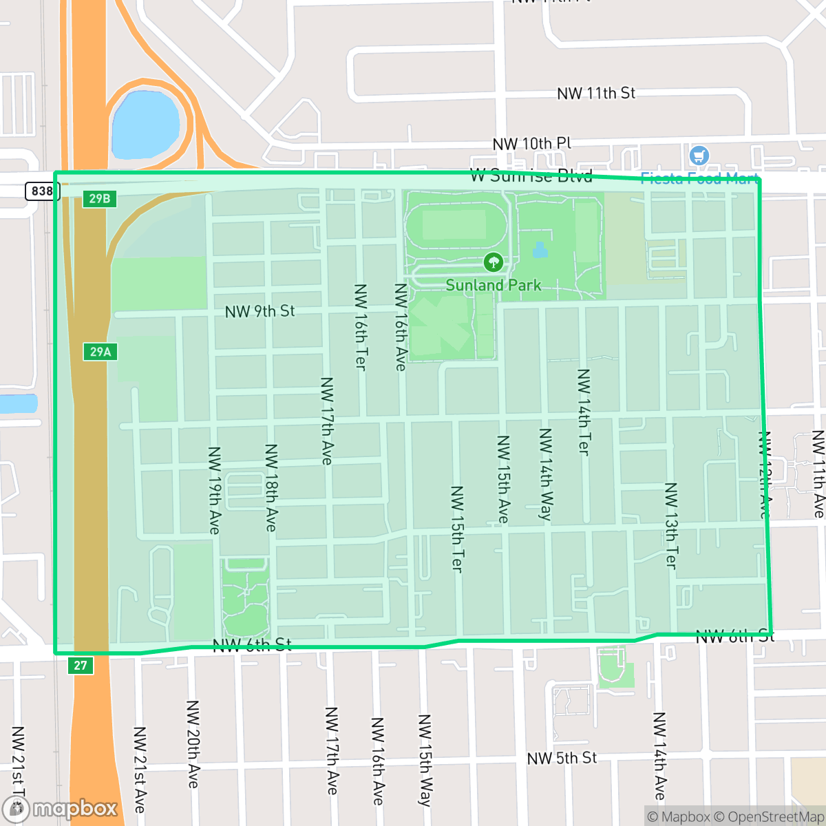
About Durrs Homeowners
The Durrs neighborhood, located in Fort Lauderdale’s historic Northwest District, is a residential community with deep roots in the city's African American heritage. Developed in the mid-20th century to house working families, the area is anchored by Sistrunk Boulevard, a vital cultural and commercial artery named for Dr. James Franklin Sistrunk, a pioneering Black physician. The neighborhood is historically significant for its proximity to the Lincoln Park complex, which served as a focal point for community life but also became the site of a major environmental health crisis due to a municipal incinerator that operated nearby from the 1920s through the 1950s. This history of environmental contamination and subsequent community advocacy and legal settlements has shaped the neighborhood’s identity, emphasizing the resilience of its long-term residents and the ongoing efforts to preserve its established character.
The neighborhood maintains a steady, suburban rhythm characterized by modest tract housing and a mix of detached homes and multi-family units. Its location provides a transition between dense urban development and more open, dispersed residential pockets. While the area is largely residential, light commercial activity exists near major transit corridors, contributing to a consistent, moderate level of local activity according to iHuus data. Prospective residents should consider the trade-offs associated with the area, including higher noise levels from flight paths and road traffic, as well as the necessity for flood insurance due to its location in a designated floodplain. While the local air quality is generally good, the presence of a nearby Superfund site and limited public greenery are important factors for long-term planning. The community is served by the Broward County School District, which is currently undergoing significant structural and budgetary changes.
Neighborhood Scores Across 15 Qualities
Residential spacing is roughly average for Fort Lauderdale, featuring a mix of closely packed multi-family clusters and detached homes with small yards. According to iHuus data, some areas contain tightly grouped structures that offer limited buffer between neighbors.
Quiet streets and a grid layout facilitate walking, though nearby highways and rail lines act as significant pedestrian barriers. According to iHuus data, the neighborhood offers slightly less walkability than the Fort Lauderdale average due to these infrastructure obstacles.
Modest tract housing and small yards characterize the area, which offers less visual variety than the Fort Lauderdale average. According to iHuus data, the landscape consists primarily of dense residential clusters and functional apartment complexes.
Public park access and wide green verges are scarce in this area, making it less dog friendly than the Fort Lauderdale average. Most greenery consists of private residential yards and narrow sidewalks near high traffic corridors.
Residential pockets feature more open land and scattered greenery than the typical Fort Lauderdale urban layout. According to iHuus data, this area provides a transition between dense suburban development and more dispersed, low-density housing.
Residential streets and local dining spots provide a consistent, moderate level of activity that is slightly below the Fort Lauderdale average. According to iHuus data, this area offers a balanced mix of transit-accessible services and quiet suburban pockets.
Frequent disturbances from nearby transit corridors and flight paths characterize the area. According to iHuus data, acoustic comfort in this neighborhood is slightly below the Fort Lauderdale average.
Air quality remains consistently good with rare instances of elevated readings. This level of cleanliness is notably higher than the average for Fort Lauderdale, according to iHuus data.
Light commercial activity and occasional truck traffic are present near transit corridors, though the area remains largely residential with no heavy industrial presence. Residents should note that a nearby Superfund site may pose potential environmental risks to soil or groundwater, according to iHuus data.
Health insurance accessibility within the neighborhood is lower than the Fort Lauderdale average. According to iHuus data, a significant portion of the local population lacks coverage.
Voting patterns and census indicators show a much more liberal leaning than the Fort Lauderdale average, according to iHuus data.
Residents live alongside a balanced mix of young adults, families, and older individuals; according to iHuus data, this demographic spread is slightly less varied than the average found across Fort Lauderdale.
Properties within this area are situated inside a designated floodplain, which typically necessitates flood insurance. According to iHuus data, the vulnerability to flooding is slightly higher than the Fort Lauderdale average.
Address-Level Insights for Durrs Homeowners


iHuus Neighborhood Intelligence Insights
Get address-level neighborhood insights for Durrs Homeowners
- Street-level scores — see how individual blocks compare, not just neighborhood averages
- Micro-zone boundaries — identify quiet pockets, flood boundaries, and walkable clusters before you visit
- 15 dimensions in full — walkability, noise, air quality, school quality, insurance coverage, population age profile, urban/rural index, and more
- Boundary risk alerts — know if your address sits near a block boundary where scores drop, the kind of detail no listing will ever mention
- School insights — individual school ratings and insights, not just district-level data
- Compare before you commit — side-by-side data across neighborhoods, down to block precision
No credit card required
Compare with Any Neighborhood
| Dimension | Durrs Homeowners | Bal Harbour |
|---|---|---|
| 🚶 Walkabilityavg 6.6 | ||
| 🔊 Acoustic Comfortavg 3.24 | ||
| 🤫 Privacy Indexavg 5.33 | ||
| 🎨 Visual Appealavg 6.66 | ||
| 🐕 Dog Friendlinessavg 4.88 | ||
| 🗺️ Urban-Rural Indexavg 6.04 | ||
| ✨ Neighborhood Vibeavg 4.63 | ||
| 🏥 Health Insurance Coverageavg 6.16 | ||
| 🌿 Air Qualityavg 6.61 | ||
| 🏭 Industrial Proximityavg 6.49 | ||
| 🌊 Flood Safetyavg 3.54 | ||
| 🗳️ Ideological Leanavg 6.3 | ||
| 👥 Population Age Profileavg 5.2 | ||
| 🔥 Fire Safety | ||
| 🏫 School Quality |
Durrs Homeowners Rankings
School Districts Serving Durrs Homeowners
School Insights for Durrs Homeowners
Below average outcomes; significant attendance and academic challenges.
School Insights
See what's really behind every school rating near Durrs Homeowners
- Individual school ratings — each school's own score with outcome context, not just a district average
- Enrollment & class size data — student-to-teacher ratio and how it compares to the state average
- Full demographics breakdown — ethnicity and gender composition for every school in the enrollment zone
- Every school in the district — all schools within the enrollment boundary ranked by rating, not just the closest one
- Grade levels & benchmarks — elementary through high school, with below/above state-average flags
No credit card required