Dorsey-Riverbend, Fort Lauderdale
Updated · 4,876 residents
Dorsey-Riverbend is a historic community known for its mid-century residential architecture and strong Caribbean cultural roots. While the area offers a balanced mix of urban and suburban living, residents often encounter traffic noise and should be aware of elevated flood risks.
Key Highlights
About Dorsey-Riverbend
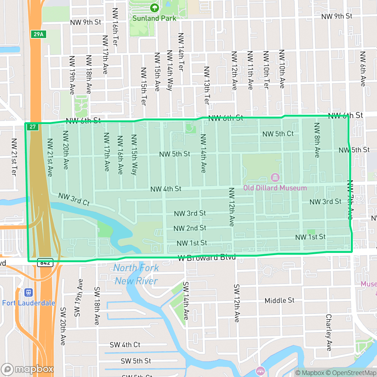
The Dorsey-Riverbend neighborhood in Fort Lauderdale is a historic urban community named in honor of Dana Dorsey, a pioneering Black real estate developer and philanthropist who was instrumental in providing housing for Black workers across South Florida during the early 20th century. Situated in the city's northwest district near the New River, the area served as a vital enclave for the Black community during the era of segregation. The neighborhood is characterized by its mid-century residential stock, primarily constructed between 1940 and 1969, and maintains a distinct cultural identity marked by a significant Caribbean heritage, particularly among residents of Jamaican ancestry. Today, Dorsey-Riverbend remains a focal point for urban living, valued for its proximity to downtown Fort Lauderdale and its enduring legacy as a foundational community for the city's working families.
The neighborhood features a diverse landscape ranging from modest single-family homes to denser apartment complexes, providing a varied residential experience near downtown Fort Lauderdale. Its urban-suburban character is defined by a blend of residential streets and pockets of light industrial activity, including warehouses and storage facilities, particularly in the northern sections. This area maintains a unique cultural identity, supported by a balanced demographic of young adults, families, and seniors who appreciate the central location and access to city amenities. Prospective residents should consider that the area experiences frequent noise from nearby major roadways and transit corridors, which can impact acoustic comfort. While the neighborhood offers moderate walkability, highway and rail lines occasionally serve as barriers for pedestrians. According to iHuus data, the area benefits from notably clean air quality, though it remains in a high-risk zone for flooding. Families should also note that local schools operate within the Broward County district, which is currently undergoing significant structural and budgetary transitions.
Neighborhood Scores Across 15 Qualities
Housing structures vary from closely packed multi-family units to homes with small yards, resulting in a sense of privacy that is slightly lower than the Fort Lauderdale average.
Residential streets offer decent sidewalk connectivity, though nearby highway and rail lines act as significant barriers for pedestrians. According to iHuus data, walking ease in this area is slightly below the Fort Lauderdale average.
Visual variety ranges from modest single-family homes and apartment complexes to waterfront properties with private docks. This mix of residential and industrial elements results in a landscape that is slightly less visually diverse than the Fort Lauderdale average.
Public park access and wide, grassy sidewalk verges are relatively sparse in this area, falling below the Fort Lauderdale average. Most greenery is contained within private residential yards, though some riverfront areas provide occasional green access.
Residential streets and green spaces are found in roughly equal measure, providing a suburban feel that is slightly more developed than the Fort Lauderdale average. This area features a transition between multi-story apartment complexes, single-family homes, and commercial zones.
Activity levels are slightly higher than the Fort Lauderdale average, offering a mix of dense urban pockets with dining and entertainment alongside quieter suburban stretches. Residents can experience everything from highly walkable, culturally vibrant zones to more subdued residential areas near transit hubs.
Constant sounds from nearby major roadways and transit corridors characterize the area. According to iHuus data, acoustic disruption levels are slightly higher than the Fort Lauderdale average.
Air quality remains consistently clean with rare instances of elevated readings. This level of air purity is notably higher than the Fort Lauderdale average, according to iHuus data.
Occasional warehouses, auto-salvage yards, and storage facilities introduce light industrial activity and heavy freight traffic to certain northern sectors. While this level of industrial presence is roughly in line with the Fort Lauderdale average, residents should be aware of potential utility odors and proximity to a nearby Superfund site according to iHuus data.
Health insurance accessibility in this area is slightly below the Fort Lauderdale average. According to iHuus data, a significant portion of the population lacks coverage.
Voting patterns and census indicators show a significantly more liberal political leaning than the Fort Lauderdale average, according to iHuus data.
A balanced demographic of young adults, families, and seniors resides here. This age distribution is slightly more varied than the Fort Lauderdale average according to iHuus data.
Property within the 100-year floodplain is subject to elevated flood risks; according to iHuus data, this area presents a higher vulnerability level than much of Fort Lauderdale.
Address-Level Insights for Dorsey-Riverbend


iHuus Neighborhood Intelligence Insights
Get address-level neighborhood insights for Dorsey-Riverbend
- Street-level scores — see how individual blocks compare, not just neighborhood averages
- Micro-zone boundaries — identify quiet pockets, flood boundaries, and walkable clusters before you visit
- 15 dimensions in full — walkability, noise, air quality, school quality, insurance coverage, population age profile, urban/rural index, and more
- Boundary risk alerts — know if your address sits near a block boundary where scores drop, the kind of detail no listing will ever mention
- School insights — individual school ratings and insights, not just district-level data
- Compare before you commit — side-by-side data across neighborhoods, down to block precision
No credit card required
Compare with Any Neighborhood
| Dimension | Dorsey-Riverbend | Bal Harbour |
|---|---|---|
| 🚶 Walkabilityavg 6.6 | ||
| 🔊 Acoustic Comfortavg 3.24 | ||
| 🤫 Privacy Indexavg 5.33 | ||
| 🎨 Visual Appealavg 6.66 | ||
| 🐕 Dog Friendlinessavg 4.88 | ||
| 🗺️ Urban-Rural Indexavg 6.04 | ||
| ✨ Neighborhood Vibeavg 4.63 | ||
| 🏥 Health Insurance Coverageavg 6.16 | ||
| 🌿 Air Qualityavg 6.61 | ||
| 🏭 Industrial Proximityavg 6.49 | ||
| 🌊 Flood Safetyavg 3.54 | ||
| 🗳️ Ideological Leanavg 6.3 | ||
| 👥 Population Age Profileavg 5.2 | ||
| 🔥 Fire Safety | ||
| 🏫 School Quality |
Dorsey-Riverbend Rankings
School Districts Serving Dorsey-Riverbend
School Insights for Dorsey-Riverbend
Below average outcomes; significant attendance and academic challenges.
School Insights
See what's really behind every school rating near Dorsey-Riverbend
- Individual school ratings — each school's own score with outcome context, not just a district average
- Enrollment & class size data — student-to-teacher ratio and how it compares to the state average
- Full demographics breakdown — ethnicity and gender composition for every school in the enrollment zone
- Every school in the district — all schools within the enrollment boundary ranked by rating, not just the closest one
- Grade levels & benchmarks — elementary through high school, with below/above state-average flags
No credit card required