Triangle, West Sacramento
Updated June 22, 2026 · 200 residents
The Triangle serves as a vibrant riverside destination defined by landmarks like Sutter Health Park and the iconic Barn. While the area offers a unique blend of modern residential and commercial activity, residents should anticipate notable noise levels from nearby highway traffic and moderate walkability.
Key Highlights
About Triangle
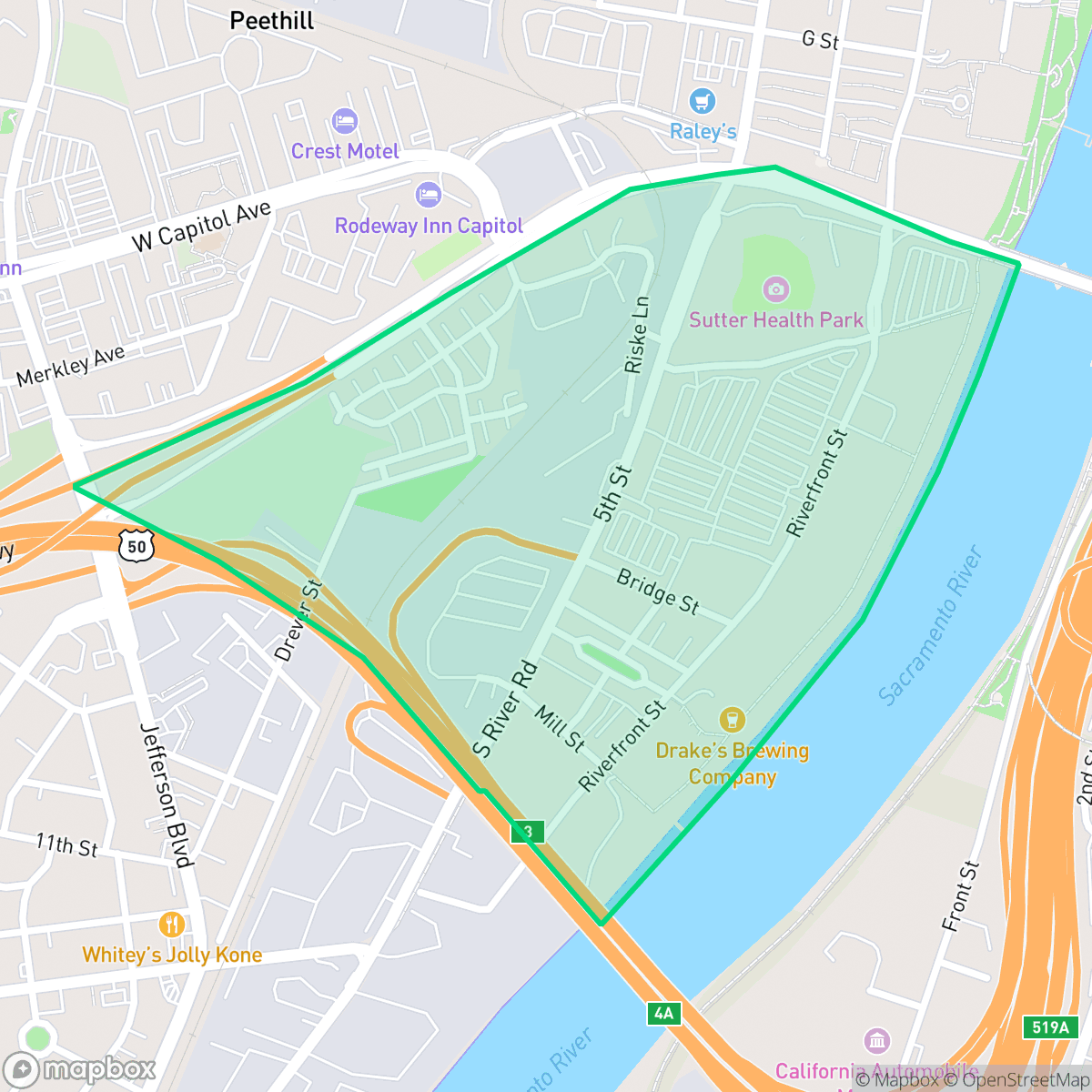
Originally known as the Triangle and later rebranded as the Bridge District, this 188-acre waterfront neighborhood in West Sacramento is bounded by the Sacramento River, Highway 50, and Tower Bridge Gateway. For much of the 20th century, the area was a heavy industrial hub, hosting massive operations like the Rice Growers Association of California storage silos, a CEMEX cement terminal, and the State Box Company. Guided by the 1993 Triangle Specific Plan (updated in 2009), the neighborhood underwent a dramatic urban renewal, transforming from an industrial zone into a walkable, mixed-use green community. Today, the neighborhood's industrial past blends with modern landmarks, including Sutter Health Park (home of the Sacramento River Cats) and the architecturally striking outdoor venue, Drake’s Brewing Company at The Barn.
This neighborhood functions as a dynamic, mixed-use environment that balances its industrial legacy with contemporary urban development. It attracts those seeking proximity to major regional entertainment hubs and riverside attractions, providing a distinct atmosphere that contrasts with the quieter, suburban pockets of West Sacramento. The area maintains a steady flow of daytime commercial activity, creating a lively environment for visitors and residents alike who prioritize access to local amenities over complete acoustic seclusion.
Prospective residents should consider the acoustic profile of the area, as data indicates a significant impact from road traffic. While the neighborhood provides a unique, modern lifestyle, its walkability is moderate, and families should evaluate the broader Washington Unified School District, which presents a mix of specialized academic pathways alongside challenges in consistency and academic rigor across its elementary schools. It is best suited for individuals or couples who value a central, active location and are comfortable with the trade-offs of living in a high-traffic urban corridor.
Neighborhood Scores Across 15 Qualities
Residential spacing is mixed with some buffer between neighbors, mirroring the typical density found across West Sacramento. According to iHuus data, this provides a balance of openness and proximity to adjacent properties.
Low traffic volumes make for peaceful walking conditions, though the lack of sidewalks means pedestrians must share the road with vehicles. This level of walkability is notably lower than the West Sacramento average, according to iHuus data.
Typical residential architecture features uniform rooflines and compact yards. This landscape is slightly less varied than the West Sacramento average according to iHuus data.
Opportunities for pet exercise are scarce due to a lack of wide green verges and limited direct access to public parks. According to iHuus data, this area offers fewer walking options for dogs compared to the West Sacramento average.
Large-scale warehouses and transportation infrastructure create a dense, low-density urban landscape that is slightly more developed than the West Sacramento average. This area features a mix of industrial facilities and multi-family housing rather than open fields or woodlands.
Primarily composed of industrial and suburban blocks, this area offers a calm atmosphere with limited social density. According to iHuus data, the level of activity and local vibrancy is consistent with the average for West Sacramento.
Frequent noise from nearby railroad tracks and major freeways is common in this area. This level of acoustic disturbance is higher than the West Sacramento average, according to iHuus data.
Air quality in this area fluctuates between acceptable and unhealthy levels, presenting occasional concerns for sensitive groups. According to iHuus data, these conditions are largely consistent with the average found throughout West Sacramento.
A blend of commercial logistics hubs and light industrial facilities exists alongside residential areas, resulting in higher levels of heavy vehicle traffic and noise than the West Sacramento average. While some pockets feature only local restaurants, other sections contain significant warehouse operations and industrial storage tanks.
Health insurance accessibility is strong in this area, with coverage rates sitting above the West Sacramento average according to iHuus data.
Voting patterns and census indicators in this area reflect a predominantly liberal leaning, slightly more so than the West Sacramento average.
Residents live alongside a balanced mix of young adults, families, and older individuals. According to iHuus data, this demographic spread is slightly lower than the West Sacramento average.
Residual flood risk exists within this area as it sits within the 500-year floodplain, though safety levels remain comparable to the West Sacramento average according to iHuus data.
Block-Level Insights for Triangle

iHuus Neighborhood Intelligence Insights
Get block-level neighborhood insights for Triangle
- Street-level scores — see how individual blocks compare, not just neighborhood averages
- Micro-zone boundaries — identify quiet pockets, flood boundaries, and walkable clusters before you visit
- 15 dimensions in full — walkability, noise, air quality, school quality, insurance coverage, population age profile, urban/rural index, and more
- Boundary risk alerts — know if your address sits near a block boundary where scores drop, the kind of detail no listing will ever mention
- School insights — individual school ratings and insights, not just district-level data
- Compare before you commit — side-by-side data across neighborhoods, down to block precision
No credit card required
Compare with Any Neighborhood
| Dimension | Triangle | Broderrick/Bryte |
|---|---|---|
| 🚶 Walkabilityavg 8.33 | ||
| 🔊 Acoustic Comfortavg 4.31 | ||
| 🤫 Privacy Indexavg 5.47 | ||
| 🎨 Visual Appealavg 6.52 | ||
| 🐕 Dog Friendlinessavg 7.26 | ||
| 🗺️ Urban-Rural Indexavg 6.86 | ||
| ✨ Neighborhood Vibeavg 3.48 | ||
| 🏥 Health Insurance Coverageavg 7.88 | ||
| 🌿 Air Qualityavg 6.1 | ||
| 🏭 Industrial Proximityavg 7.34 | ||
| 🌊 Flood Safetyavg 7.06 | ||
| 🗳️ Ideological Leanavg 8.96 | ||
| 👥 Population Age Profileavg 4.78 | ||
| 🔥 Fire Safety | ||
| 🏫 School Quality |
Triangle Rankings
School Districts Serving Triangle
Washington Unified School District is a 'Mixed/Transition' organization characterized by a sharp disparity between its prestigious specialized pathways and its struggling neighborhood elementary schools. While the district earns high marks for its innovative 'Home Run' initiative and Career Technical Education (CTE) programs—which maintain strong community support—it is currently hampered by significant academic gaps, with nearly 30% of its schools rated 2/10 or lower. Operational stability is tested by projected budget shortfalls and high teacher turnover, creating a bifurcated environment where specialized students thrive while the broader student body faces inconsistent safety and academic rigor. The district remains a viable option due to its strong terminal programs, but it lacks the systemic excellence required for a higher stability rating.
Schools
School Insights for Triangle
Below average outcomes; significant attendance and academic challenges.
School Insights
See what's really behind every school rating near Triangle
- Individual school ratings — each school's own score with outcome context, not just a district average
- Enrollment & class size data — student-to-teacher ratio and how it compares to the state average
- Full demographics breakdown — ethnicity and gender composition for every school in the enrollment zone
- Every school in the district — all schools within the enrollment boundary ranked by rating, not just the closest one
- Grade levels & benchmarks — elementary through high school, with below/above state-average flags
No credit card required