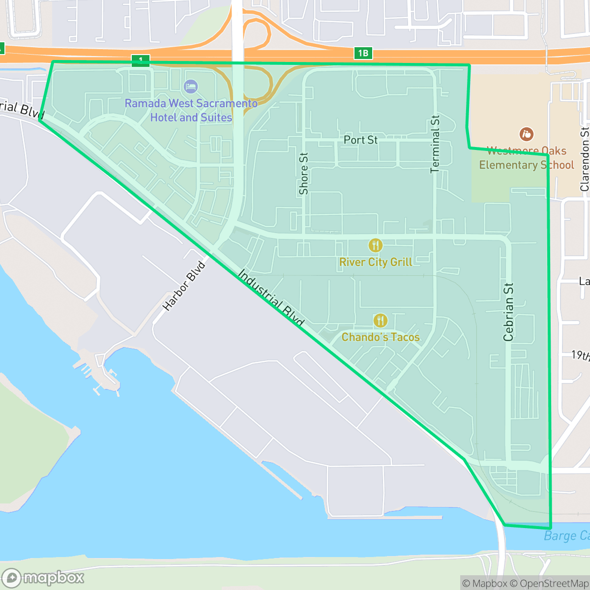
North of Port Indust., West Sacramento
Updated June 22, 2026 · 751 residents
North of Port Indust. is a specialized logistics and industrial corridor in West Sacramento defined by its large-scale warehouse facilities and heavy freight traffic. The area is primarily a car-dependent zone characterized by high ambient noise levels from nearby highways and limited amenities for residents.
Key Highlights
About North of Port Indust.
The neighborhood functions as a vital logistics hub within West Sacramento, dominated by expansive warehouse footprints and significant industrial infrastructure. Its landscape is defined by wide, paved surfaces and a steady flow of heavy distribution traffic, creating an environment focused on commerce rather than residential density. While the area offers proximity to major transit routes, the daily experience is marked by high noise levels from road traffic and a lack of pedestrian-friendly infrastructure, making it a challenging environment for those seeking a quiet or walkable lifestyle.
Living in this area requires navigating trade-offs between industrial utility and residential comfort. According to data, the neighborhood features very low acoustic comfort and limited dog-friendly spaces, reflecting its status as a commercial and industrial zone. While it provides excellent health insurance coverage for its population, the area is best suited for those working in the logistics sector or individuals who prioritize proximity to major regional transit corridors over traditional neighborhood amenities.
Neighborhood Scores Across 15 Qualities
Residential spacing provides some buffer between neighbors, though levels of seclusion are slightly lower than the West Sacramento average according to iHuus data.
Pedestrian infrastructure is somewhat restricted as sidewalks are often only present on one side of the street. This level of walkability is lower than the average found throughout West Sacramento.
Residential views consist primarily of standard tract housing with small yards and simple rooflines. This area offers less visual variety than the West Sacramento average.
Access to public parks and green verges for walking dogs is below the West Sacramento average. According to iHuus data, this area lacks the extensive open greenery found in other parts of the city.
Large-scale warehouses, transit hubs, and industrial infrastructure dominate the landscape alongside pockets of agricultural fields and low-density housing. This mix of industrial development and open space is consistent with the broader West Sacramento area.
Primarily composed of industrial warehouses and suburban blocks, this area lacks significant pedestrian activity and requires a vehicle for most errands. Social density is low compared to the West Sacramento average, with limited local businesses situated near major highways and railway corridors.
Frequent noise from nearby railroad tracks and heavy freeway traffic characterizes this area. According to iHuus data, acoustic comfort is significantly lower than the West Sacramento average.
Air quality levels fluctuate between acceptable and unhealthy for sensitive groups. According to iHuus data, these conditions are roughly in line with the average found throughout West Sacramento.
Active logistics hubs and heavy port infrastructure exist alongside residential pockets, creating a landscape that is more industrial than the West Sacramento average. Residents may encounter significant truck traffic and large-scale warehouse operations near the western edge of the neighborhood.
Health insurance access is exceptionally high for this area, significantly surpassing the West Sacramento average according to iHuus data.
Voting patterns and census indicators in this area align with the broadly liberal political landscape of West Sacramento. According to iHuus data, the political leaning here is largely consistent with the city average.
Residents live alongside a balanced mix of young adults, families, and older individuals. This demographic spread is slightly more varied than the West Sacramento average, according to iHuus data.
Flood risk in this area is slightly above the West Sacramento average due to its location within a 500-year floodplain. Residents should be aware of some residual flood potential according to iHuus data.
Block-Level Insights for North of Port Indust.

iHuus Neighborhood Intelligence Insights
Get block-level neighborhood insights for North of Port Indust.
- Street-level scores — see how individual blocks compare, not just neighborhood averages
- Micro-zone boundaries — identify quiet pockets, flood boundaries, and walkable clusters before you visit
- 15 dimensions in full — walkability, noise, air quality, school quality, insurance coverage, population age profile, urban/rural index, and more
- Boundary risk alerts — know if your address sits near a block boundary where scores drop, the kind of detail no listing will ever mention
- School insights — individual school ratings and insights, not just district-level data
- Compare before you commit — side-by-side data across neighborhoods, down to block precision
No credit card required
Compare with Any Neighborhood
| Dimension | North of Port Indust. | Broderrick/Bryte |
|---|---|---|
| 🚶 Walkabilityavg 8.33 | ||
| 🔊 Acoustic Comfortavg 4.31 | ||
| 🤫 Privacy Indexavg 5.47 | ||
| 🎨 Visual Appealavg 6.52 | ||
| 🐕 Dog Friendlinessavg 7.26 | ||
| 🗺️ Urban-Rural Indexavg 6.86 | ||
| ✨ Neighborhood Vibeavg 3.48 | ||
| 🏥 Health Insurance Coverageavg 7.88 | ||
| 🌿 Air Qualityavg 6.1 | ||
| 🏭 Industrial Proximityavg 7.34 | ||
| 🌊 Flood Safetyavg 7.06 | ||
| 🗳️ Ideological Leanavg 8.96 | ||
| 👥 Population Age Profileavg 4.78 | ||
| 🔥 Fire Safety | ||
| 🏫 School Quality |
North of Port Indust. Rankings
School Districts Serving North of Port Indust.
Washington Unified School District is a 'Mixed/Transition' organization characterized by a sharp disparity between its prestigious specialized pathways and its struggling neighborhood elementary schools. While the district earns high marks for its innovative 'Home Run' initiative and Career Technical Education (CTE) programs—which maintain strong community support—it is currently hampered by significant academic gaps, with nearly 30% of its schools rated 2/10 or lower. Operational stability is tested by projected budget shortfalls and high teacher turnover, creating a bifurcated environment where specialized students thrive while the broader student body faces inconsistent safety and academic rigor. The district remains a viable option due to its strong terminal programs, but it lacks the systemic excellence required for a higher stability rating.
Schools
School Insights for North of Port Indust.
Below average outcomes; significant attendance and academic challenges.
School Insights
See what's really behind every school rating near North of Port Indust.
- Individual school ratings — each school's own score with outcome context, not just a district average
- Enrollment & class size data — student-to-teacher ratio and how it compares to the state average
- Full demographics breakdown — ethnicity and gender composition for every school in the enrollment zone
- Every school in the district — all schools within the enrollment boundary ranked by rating, not just the closest one
- Grade levels & benchmarks — elementary through high school, with below/above state-average flags
No credit card required