Van Buskirk, Stockton
Updated June 22, 2026 · 11,964 residents
Van Buskirk is a quiet, suburban enclave in south Stockton characterized by dense, uniform tract housing and a layout that balances residential blocks with nearby industrial corridors. Residents benefit from a highly walkable street network, though the area is defined by its proximity to major highways and ongoing efforts to repurpose former recreational land into public green space.
Key Highlights
About Van Buskirk
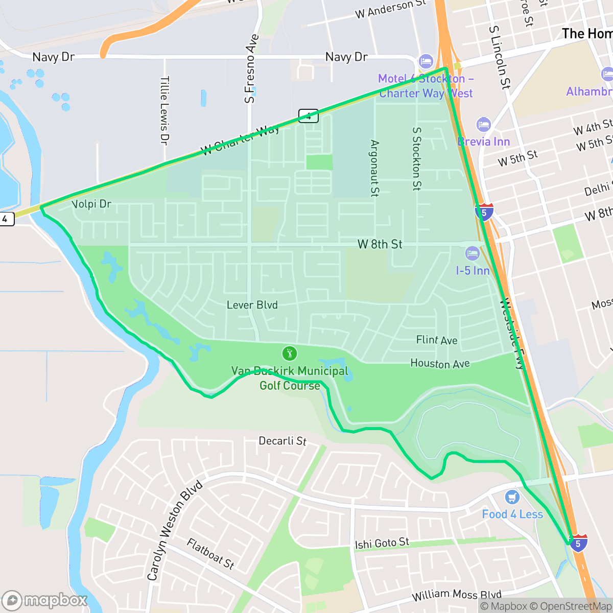
The Van Buskirk neighborhood in south Stockton, California, is historically anchored by a 214-acre parcel of land deeded to the city in 1957 by Charles and Bertha Van Buskirk. Bordered by Houston Avenue and the San Joaquin River, this land was donated under the condition that it remain dedicated to public recreation. It operated as the Van Buskirk Municipal Golf Course from 1961 until its closure in 2019 due to rising maintenance costs. Today, the former golf course is the focus of a major multi-phase revitalization project. The initiative aims to transform the space into a multi-purpose park featuring a community center, sports facilities, and nature trails, while simultaneously restoring the historic wetlands of the San Joaquin River floodplain to provide vital flood protection for the surrounding working-class neighborhood.
The area features a dense suburban design with homes situated in close proximity, creating a tight-knit residential pattern. While the neighborhood maintains a calm atmosphere, it is positioned near significant freight corridors and industrial zones, which contribute to steady levels of ambient noise and heavy vehicle traffic. Daily amenities are somewhat limited, often requiring residents to commute outside the immediate vicinity for shopping or services, though the local street grid is well-connected for pedestrians. Prospective residents should consider the trade-off between the neighborhood's accessibility and its industrial surroundings. While the area offers a stable suburban environment, it is influenced by nearby environmental factors, including the presence of an EPA Superfund site and the noise profile associated with its location near major transportation arteries. According to iHuus data, the community is best suited for those prioritizing suburban connectivity and proximity to key regional transit routes over a high-density commercial or entertainment district.
Neighborhood Scores Across 15 Qualities
Residential spacing is relatively tight with many houses positioned closely together and sharing fence lines. This level of density is slightly higher than the Stockton average, providing less separation between neighbors than typical suburban tracts.
Pedestrian access is well-supported by a consistent sidewalk network and clear crossings at major intersections, performing slightly above the Stockton average. While residential blocks are easy to navigate, nearby highway and industrial zones can act as significant barriers to movement.
Residential views consist primarily of uniform tract housing with modest yards and consistent rooflines. According to iHuus data, the visual variety in this area is slightly below the Stockton average.
Accessible walking routes and expansive public school fields provide ample space for pets. According to iHuus data, the availability of connected green belts and park paths in this area is higher than the Stockton average.
A blend of dense suburban housing and open agricultural fields characterizes this area. Residents will find a landscape of scattered homes and undeveloped land that is slightly more rural than the Stockton average.
Low density and industrial presence create a quiet, subdued atmosphere that lacks significant social activity. Most daily needs and dining options require driving, as the area has much less commercial vibrancy than the Stockton average.
Persistent noise from nearby railroad tracks and major freeways characterizes this area. According to iHuus data, acoustic comfort in Van Buskirk is lower than the Stockton average.
Air quality in this area fluctuates between acceptable and unhealthy levels, matching the typical conditions found throughout Stockton. Sensitive groups may experience occasional concerns during certain periods according to iHuus data.
Residential life predominates here with limited industrial activity, though a nearby Superfund site may present environmental considerations regarding soil and groundwater. While the area is quieter than the city average, some pockets experience heavy freight traffic and noise from local storage facilities.
Health insurance access is lower in this area than the Stockton average, according to iHuus data. Residents may find fewer options for locally-based coverage compared to other parts of the city.
Voting patterns and census indicators reflect a predominantly liberal leaning that is more pronounced than the Stockton average, according to iHuus data.
Residents live alongside a varied mix of young adults, families, and seniors. This age distribution is slightly more varied than the typical profile found across Stockton.
Flood safety in this area is higher than the Stockton average, though some residual risk remains due to its location within a 500-year floodplain. According to iHuus data, residents may face minor flood concerns during extreme weather events.
Block-Level Insights for Van Buskirk

iHuus Neighborhood Intelligence Insights
Get block-level neighborhood insights for Van Buskirk
- Street-level scores — see how individual blocks compare, not just neighborhood averages
- Micro-zone boundaries — identify quiet pockets, flood boundaries, and walkable clusters before you visit
- 15 dimensions in full — walkability, noise, air quality, school quality, insurance coverage, population age profile, urban/rural index, and more
- Boundary risk alerts — know if your address sits near a block boundary where scores drop, the kind of detail no listing will ever mention
- School insights — individual school ratings and insights, not just district-level data
- Compare before you commit — side-by-side data across neighborhoods, down to block precision
No credit card required
Compare with Any Neighborhood
| Dimension | Van Buskirk | Anderson |
|---|---|---|
| 🚶 Walkabilityavg 8.33 | ||
| 🔊 Acoustic Comfortavg 3.04 | ||
| 🤫 Privacy Indexavg 5.32 | ||
| 🎨 Visual Appealavg 6.38 | ||
| 🐕 Dog Friendlinessavg 6.44 | ||
| 🗺️ Urban-Rural Indexavg 6.82 | ||
| ✨ Neighborhood Vibeavg 4.6 | ||
| 🏥 Health Insurance Coverageavg 6.72 | ||
| 🌿 Air Qualityavg 6 | ||
| 🏭 Industrial Proximityavg 7.71 | ||
| 🌊 Flood Safetyavg 5.9 | ||
| 🗳️ Ideological Leanavg 8.5 | ||
| 👥 Population Age Profileavg 4.59 | ||
| 🔥 Fire Safety | ||
| 🏫 School Quality |
Van Buskirk Rankings
School Districts Serving Van Buskirk
Manteca Unified School District is a system in transition, characterized by a dual-track profile of robust infrastructure growth and persistent academic challenges. While the district maintains a high 92% graduation rate and is successfully executing a $150 million facility expansion plan, its standardized test scores lag behind state averages, and there is a pronounced performance gap between its top-tier and bottom-tier elementary schools. Positive indicators include strong Career Technical Education (CTE) programs, high community trust in bond measures, and recent state recognition for high school growth, but these are offset by low proficiency rates and salary competitiveness concerns that impact support staff retention.
Schools
Tracy Unified School District is a district in transition, characterized by a sharp dichotomy between its high-performing specialized high school academies and a struggling elementary feeder system where nearly half of the schools are rated 1 or 2. Operationally, the district maintains community trust through successful facility bonds and robust vocational programs (CTE and Agriculture), yet it is besieged by the common pressures of rapid suburban growth: campus overcrowding, teacher retention challenges due to nearby high-wage markets, and a growing achievement gap in mathematics. While the district offers strong 'Blue Chip' pockets like Kimball High, the systemic underperformance at the primary level and reports of inconsistent middle school safety prevent it from achieving a higher stability rating.
Schools
Stockton Unified is currently a Distressed district (Rating: 2) characterized by a severe academic divide and significant historical instability. While the current administration has achieved notable milestones—including exceeding state graduation averages, exiting Department of Justice monitoring, and stabilizing leadership—the district's foundation remains weak, with over 20 schools rated 1/10 and math proficiency at a critical low of 17%. Recent board-level criminal scandals and funding cuts to technical programs counteract the 'Blue Chip' aspirations of its high-performing specialty academies. Despite professional management improvements, the district remains a 'high-risk' entity due to the volume of underperforming schools and persistent governance challenges.
Schools
School Insights for Van Buskirk
Below average outcomes; significant attendance and academic challenges.
School Insights
See what's really behind every school rating near Van Buskirk
- Individual school ratings — each school's own score with outcome context, not just a district average
- Enrollment & class size data — student-to-teacher ratio and how it compares to the state average
- Full demographics breakdown — ethnicity and gender composition for every school in the enrollment zone
- Every school in the district — all schools within the enrollment boundary ranked by rating, not just the closest one
- Grade levels & benchmarks — elementary through high school, with below/above state-average flags
No credit card required