Louis Park, Stockton
Updated June 22, 2026 · 2,717 residents
Louis Park is a riverfront neighborhood in Stockton defined by its namesake 60-acre park and deep cultural roots. Residents live in a dense, industrial-adjacent setting that experiences significant noise from nearby highway traffic and limited pedestrian connectivity.
Key Highlights
About Louis Park
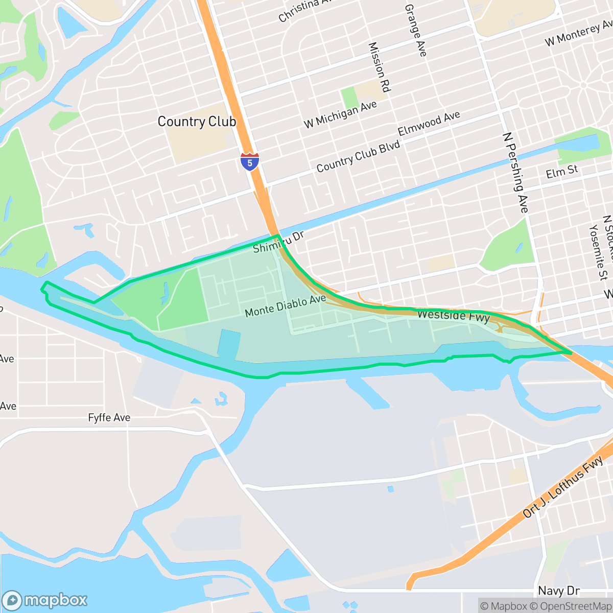
Located on the west side of Stockton, California, along the San Joaquin River, the Louis Park neighborhood is locally known as "the island" due to its surrounding waterways. The area's central landmark is the 60-acre Louis Park, which features Pixie Woods, a beloved children's fairyland theme park opened in 1955 by local volunteers inspired by Disneyland. Historically, the neighborhood underwent a significant demographic shift in the 1980s and 1990s when it became a primary resettlement hub for Southeast Asian refugees, particularly Cambodian families fleeing the Khmer Rouge genocide. This influx deeply shaped the neighborhood's cultural identity and street culture, leading to the unique formation of the Louis Park Bloods, a historically notable, multi-ethnic street gang composed of both African American and Cambodian youth.
The neighborhood sits along the San Joaquin River, blending dense residential blocks with heavy industrial facilities and shipping infrastructure. While it offers proximity to significant green space and local landmarks like Pixie Woods, the landscape is heavily influenced by its proximity to major freight corridors and manufacturing sites. The area maintains a quiet, suburban-industrial atmosphere, characterized by tightly packed housing and limited commercial amenities within walking distance.
Prospective residents should note that the area faces significant environmental and infrastructure challenges, including high noise levels from road traffic and low scores for flood and fire safety. The local school district remains in a state of academic recovery, and access to health insurance coverage is notably lower than the city average. This neighborhood is best suited for those prioritizing proximity to specific industrial work zones or established local community hubs over traditional suburban walkability or acoustic comfort.
Neighborhood Scores Across 15 Qualities
Housing density is slightly higher than the Stockton average, featuring some residential clusters where homes are spaced closely together. While some areas provide a buffer between neighbors, other sections consist of high-density layouts with minimal distance between structures.
Sidewalks are available on some streets, but large highway and industrial zones hinder easy movement through the area. Walking access is notably lower than the Stockton average due to disconnected residential streets and obstructed paths.
Uniform tract housing and small yards characterize the area, which offers slightly less visual variety than the Stockton average. Residential views are primarily composed of dense housing developments and proximity to industrial zones.
Residential streets feature narrow verges and private fenced yards with a lack of large dedicated public parks. According to iHuus data, dog walking options are below the Stockton average.
Industrial port infrastructure and transport corridors blend with residential blocks, creating a landscape that is slightly less open than the typical Stockton surroundings. This transition from dense urban elements to larger industrial zones provides a varied landscape of built and vacant land according to iHuus data.
Limited commercial activity and a heavy industrial presence create a subdued atmosphere that is notably less lively than the Stockton average. Most residents will find a quiet, car-oriented environment where social hubs are sparse and centered around a few scattered service and food businesses.
Frequent sounds from nearby railroad tracks and heavy freeway traffic are common in this area. According to iHuus data, acoustic comfort is slightly below the Stockton average.
Air quality levels in Louis Park are consistent with the Stockton average. Residents may experience a mix of acceptable and unhealthy days, which can occasionally cause concern for sensitive groups according to iHuus data.
Residential areas coexist with light commercial units and active daytime traffic, though the presence of heavy industrial zones and a nearby Superfund site creates a higher industrial density than the Stockton average. According to iHuus data, some parts of the neighborhood border large-scale manufacturing and shipping facilities.
Health insurance access is below the Stockton average, with a notable portion of the population lacking coverage. According to iHuus data, residents may face greater challenges accessing employer-sponsored healthcare plans compared to other parts of the city.
Political leanings in this area are largely liberal, though the concentration is slightly lower than the average found across Stockton.
Residents live alongside a balanced distribution of young adults, families, and older populations. This demographic spread is largely consistent with the broader Stockton area, according to iHuus data.
Significant flood risk exists here because parts of the neighborhood sit within a designated floodplain. According to iHuus data, this level of vulnerability is considerably higher than the Stockton average and often necessitates flood insurance.
Block-Level Insights for Louis Park

iHuus Neighborhood Intelligence Insights
Get block-level neighborhood insights for Louis Park
- Street-level scores — see how individual blocks compare, not just neighborhood averages
- Micro-zone boundaries — identify quiet pockets, flood boundaries, and walkable clusters before you visit
- 15 dimensions in full — walkability, noise, air quality, school quality, insurance coverage, population age profile, urban/rural index, and more
- Boundary risk alerts — know if your address sits near a block boundary where scores drop, the kind of detail no listing will ever mention
- School insights — individual school ratings and insights, not just district-level data
- Compare before you commit — side-by-side data across neighborhoods, down to block precision
No credit card required
Compare with Any Neighborhood
| Dimension | Louis Park | Anderson |
|---|---|---|
| 🚶 Walkabilityavg 8.33 | ||
| 🔊 Acoustic Comfortavg 3.04 | ||
| 🤫 Privacy Indexavg 5.32 | ||
| 🎨 Visual Appealavg 6.38 | ||
| 🐕 Dog Friendlinessavg 6.44 | ||
| 🗺️ Urban-Rural Indexavg 6.82 | ||
| ✨ Neighborhood Vibeavg 4.6 | ||
| 🏥 Health Insurance Coverageavg 6.72 | ||
| 🌿 Air Qualityavg 6 | ||
| 🏭 Industrial Proximityavg 7.71 | ||
| 🌊 Flood Safetyavg 5.9 | ||
| 🗳️ Ideological Leanavg 8.5 | ||
| 👥 Population Age Profileavg 4.59 | ||
| 🔥 Fire Safety | ||
| 🏫 School Quality |
Louis Park Rankings
School Districts Serving Louis Park
Stockton Unified is currently a Distressed district (Rating: 2) characterized by a severe academic divide and significant historical instability. While the current administration has achieved notable milestones—including exceeding state graduation averages, exiting Department of Justice monitoring, and stabilizing leadership—the district's foundation remains weak, with over 20 schools rated 1/10 and math proficiency at a critical low of 17%. Recent board-level criminal scandals and funding cuts to technical programs counteract the 'Blue Chip' aspirations of its high-performing specialty academies. Despite professional management improvements, the district remains a 'high-risk' entity due to the volume of underperforming schools and persistent governance challenges.
Schools
School Insights for Louis Park
Below average outcomes; significant attendance and academic challenges.
School Insights
See what's really behind every school rating near Louis Park
- Individual school ratings — each school's own score with outcome context, not just a district average
- Enrollment & class size data — student-to-teacher ratio and how it compares to the state average
- Full demographics breakdown — ethnicity and gender composition for every school in the enrollment zone
- Every school in the district — all schools within the enrollment boundary ranked by rating, not just the closest one
- Grade levels & benchmarks — elementary through high school, with below/above state-average flags
No credit card required