San Mateo Village, San Mateo
Updated · 4,904 residents
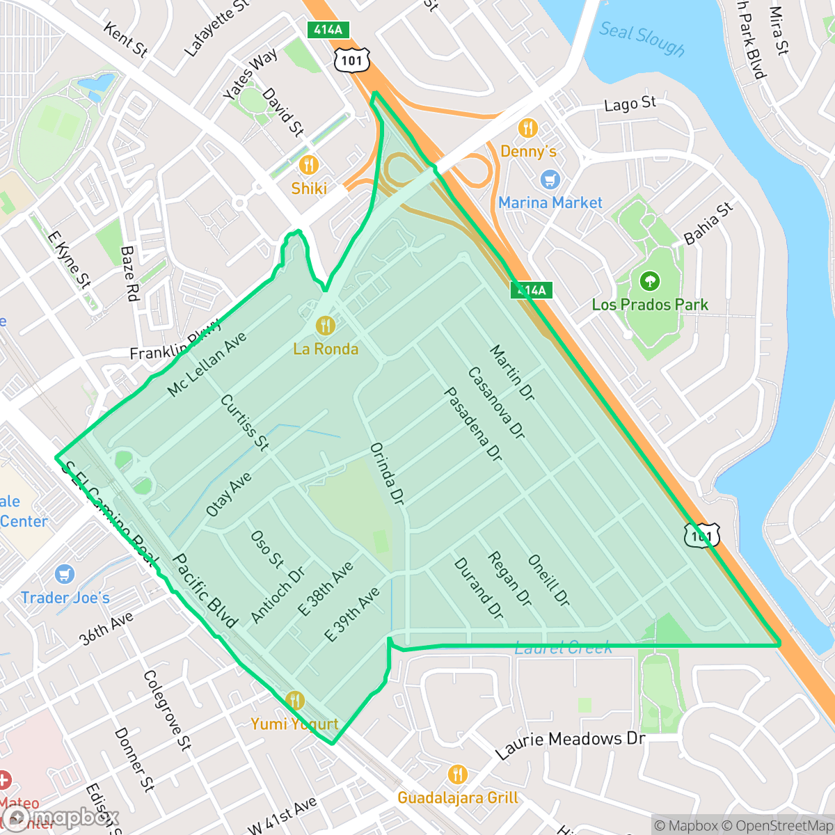
San Mateo Village is a highly walkable, dense suburban community defined by its mid-century ranch-style homes and easy access to local parks. While the area offers a vibrant dining scene and excellent pedestrian infrastructure, residents should anticipate significant road noise and potential flood risks.
Key Highlights
About San Mateo Village
San Mateo Village, colloquially known as "The Village," developed rapidly in the late 1940s and early 1950s to accommodate San Mateo’s post-World War II population boom. The neighborhood was built on annexed land, including the former McClellan Ranch. Real estate developers Conway and Culligan constructed the main tract starting in the late 1940s, while Hansen Homes, Inc. developed the adjacent Glendale Village subdivision on the McClellan estate in 1950, which was eventually absorbed into San Mateo Village. Characterized by modest, single-story mid-century ranch-style homes on roughly 5,000-square-foot lots, the neighborhood was designed as an accessible, family-oriented community. Laurel Creek flows through the area, which also features local landmarks like Casanova Park and George Hall Elementary School.
The neighborhood provides a dense suburban environment where a complete sidewalk network and a structured grid system make daily errands highly accessible on foot. According to iHuus data, the area maintains a lively atmosphere with a variety of dining options, including local favorites like La Ronda and the Cuban Kitchen. Residents benefit from high health insurance coverage and proximity to top-tier educational institutions such as George Hall Elementary and the San Mateo Union High School District, which are noted for their academic excellence and fiscal stability.
The area is best suited for those who prioritize walkability and community access over complete acoustic privacy. Potential residents should note that the neighborhood experiences notable road noise from nearby traffic and carries a higher risk profile for flooding. While the visual aesthetic remains uniform with standard tract housing, the strong sense of community and reliable public infrastructure make it a stable choice for families and professionals seeking a central location in San Mateo.
Neighborhood Scores Across 15 Qualities
Housing density varies between shared-wall apartments and detached single-family homes, offering more separation between neighbors than the San Mateo average. According to iHuus data, most residences provide a moderate buffer zone through yards or communal spaces.
Extensive sidewalk networks and dedicated pedestrian bridges over the highway provide superior connectivity for those traveling on foot. This neighborhood offers a more seamless pedestrian experience than much of San Mateo according to iHuus data.
Residential views consist of functional tract housing and multi-family units with shared amenities. This landscape is less visually varied than the San Mateo average, featuring more closely spaced homes and uniform rooftops.
Extensive green belts, interconnected trails, and wide sidewalks offer ample space for pets. This neighborhood provides more accessible walking areas for dogs than the San Mateo average, according to iHuus data.
Developed layouts featuring a combination of single-family homes, apartment complexes, and commercial strips provide a setting similar to the broader San Mateo area. This blend of residential and commercial infrastructure creates a suburban environment with notable access to local services.
Diverse dining options and local social spots create a more vibrant atmosphere than the San Mateo average. Residents can find a variety of walkable eateries and green spaces, though some areas remain car-dependent near major transit corridors.
Frequent loud disturbances from nearby airport runways and heavy rail activity characterize this area. Acoustic comfort is significantly lower than the San Mateo average according to iHuus data.
Air quality levels are consistent with the city average, though residents may encounter days with moderate pollution that could affect sensitive groups. According to iHuus data, the atmosphere fluctuates between acceptable and unhealthy conditions.
Industrial facilities, warehouses, and hazardous sites are entirely absent from this area. This neighborhood offers a cleaner environment than the San Mateo average, consisting solely of residential and commercial land use.
Nearly all residents are covered by health insurance, which is slightly higher than the average for San Mateo. This high rate of coverage indicates consistent access to medical services throughout the area.
Voting patterns and census indicators reflect a predominantly liberal community, which is consistent with the broader San Mateo area according to iHuus data.
A balanced mix of young adults, families, and older residents characterizes the area. This demographic distribution is slightly more varied than the average found across San Mateo.
Flood risk in this area is slightly above the San Mateo average, though current FEMA studies for the neighborhood remain incomplete. Residents should note that a precise assessment of inundation potential is not yet available according to iHuus data.
Address-Level Insights for San Mateo Village


iHuus Neighborhood Intelligence Insights
Get address-level neighborhood insights for San Mateo Village
- Street-level scores — see how individual blocks compare, not just neighborhood averages
- Micro-zone boundaries — identify quiet pockets, flood boundaries, and walkable clusters before you visit
- 15 dimensions in full — walkability, noise, air quality, school quality, insurance coverage, population age profile, urban/rural index, and more
- Boundary risk alerts — know if your address sits near a block boundary where scores drop, the kind of detail no listing will ever mention
- School insights — individual school ratings and insights, not just district-level data
- Compare before you commit — side-by-side data across neighborhoods, down to block precision
No credit card required
Compare with Any Neighborhood
| Dimension | San Mateo Village | Aragon |
|---|---|---|
| 🚶 Walkabilityavg 8.95 | ||
| 🔊 Acoustic Comfortavg 3.72 | ||
| 🤫 Privacy Indexavg 5.13 | ||
| 🎨 Visual Appealavg 7.16 | ||
| 🐕 Dog Friendlinessavg 6.92 | ||
| 🗺️ Urban-Rural Indexavg 6.73 | ||
| ✨ Neighborhood Vibeavg 5.61 | ||
| 🏥 Health Insurance Coverageavg 8.75 | ||
| 🌿 Air Qualityavg 6 | ||
| 🏭 Industrial Proximityavg 9.34 | ||
| 🌊 Flood Safetyavg 5.24 | ||
| 🗳️ Ideological Leanavg 9.68 | ||
| 👥 Population Age Profileavg 4.99 | ||
| 🔥 Fire Safetyavg 0.28 | ||
| 🏫 School Quality |
San Mateo Village Rankings
School Districts Serving San Mateo Village
School Insights for San Mateo Village
Below average outcomes; significant attendance and academic challenges.
School Insights
See what's really behind every school rating near San Mateo Village
- Individual school ratings — each school's own score with outcome context, not just a district average
- Enrollment & class size data — student-to-teacher ratio and how it compares to the state average
- Full demographics breakdown — ethnicity and gender composition for every school in the enrollment zone
- Every school in the district — all schools within the enrollment boundary ranked by rating, not just the closest one
- Grade levels & benchmarks — elementary through high school, with below/above state-average flags
No credit card required