Nineteenth Avenue, San Mateo
Updated June 22, 2026 · 1,872 residents
Nineteenth Avenue is a distinctive modernist enclave defined by its midcentury Eichler homes and dense suburban layout. While the area offers a unique architectural identity, residents must navigate the trade-offs of living near major regional highways, which contribute to elevated ambient noise levels and limited pedestrian connectivity.
Key Highlights
About Nineteenth Avenue
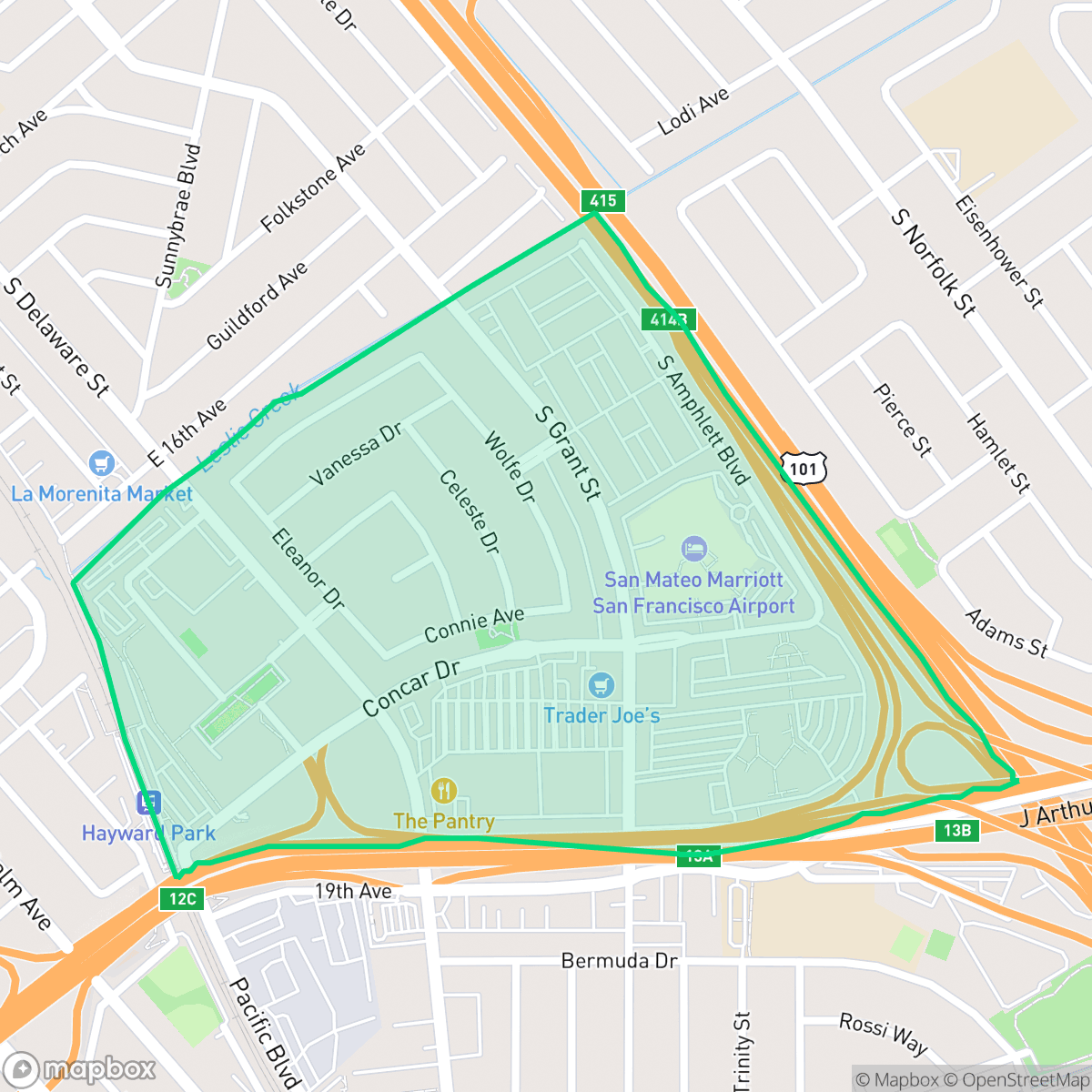
San Mateo’s Nineteenth Avenue Park neighborhood is a historically significant midcentury enclave developed between 1953 and 1955. Originally owned by the Leslie Salt company, the tract was developed by pioneering builder Joseph Eichler, featuring nearly 240 modest, modernist homes designed by architects Jones & Emmons. Unlike many other Eichler developments that targeted affluent professionals, Nineteenth Avenue Park began as a diverse, middle-class, and blue-collar community. From its inception, it welcomed an unusually high percentage of Asian-American residents at a time when housing discrimination was widespread in the region. The neighborhood's close-knit character was championed by notable residents like former San Mateo Mayor Roy Archibald, who lived on Edna Way and for whom the local park is named. Today, this modern enclave remains a resilient community nestled near the intersection of Highways 92 and 101.
The area functions as a dense suburban pocket characterized by its uniform midcentury residential architecture and proximity to major commercial and transit arteries. Residents benefit from a well-established sidewalk network, although the presence of multi-lane highways and light industrial zones creates significant barriers to foot travel and impacts the overall quietude of the neighborhood. According to iHuus data, the community maintains a consistent urban-rural balance, blending single-family residences with nearby apartment complexes and commercial facilities.
Prospective residents should weigh the architectural appeal against the practical realities of the location. While the area provides access to high-performing schools within the San Mateo Union High School District, the proximity to major roadways results in constant traffic noise and a lower privacy index compared to the broader city. The neighborhood is best suited for those who prioritize midcentury design and central access to the Peninsula over the silence of a secluded residential street.
Neighborhood Scores Across 15 Qualities
Residential structures are frequently positioned close to one another with minimal separation between neighbors. This level of density indicates less privacy than the typical San Mateo neighborhood, according to iHuus data.
Residential streets feature consistent sidewalks and safe crossings, though the nearby major freeway creates a significant barrier for pedestrians. This level of walkability is slightly lower than the average for San Mateo according to iHuus data.
Standard tract housing and mid-density apartments characterize the area, featuring uniform rooflines and small, shared lots. The visual variety in this neighborhood is lower than the San Mateo average.
Private yards and narrow sidewalks dominate the area, which lacks the large public parks or expansive green trails found elsewhere in San Mateo. According to iHuus data, the neighborhood provides fewer opportunities for off-leash exercise compared to the city average.
Residential pockets offer a blend of single-family homes and denser apartment structures, presenting a landscape that is slightly more developed than the San Mateo average.
A blend of calm residential streets and active social hubs characterizes the area, though the overall energy sits slightly below the San Mateo average. Residents can access various local parks and dining options, but the presence of light industrial units and proximity to a major highway creates a varied atmosphere.
Frequent disturbances from a nearby railroad and major freeway are common in this area. According to iHuus data, acoustic comfort is significantly lower than the San Mateo city average.
Air quality in this area remains consistent with the San Mateo average, though sensitive groups may encounter occasional periods of unhealthy air. According to iHuus data, the atmosphere fluctuates between acceptable and concerning levels depending on local conditions.
Primarily residential in nature, this area features occasional light commercial zones and parking areas. While the neighborhood lacks heavy industry, some edges are bordered by large warehouses and multi-lane highways that may introduce more noise and traffic than the San Mateo average.
Health insurance access is notably lower than the San Mateo average, according to iHuus data. Residents may find fewer-than-average coverage options within this specific neighborhood area.
Voting patterns and census indicators reflect a predominantly liberal political landscape, which is slightly more pronounced here than in the rest of San Mateo.
A varied demographic of young adults, families, and seniors characterizes this area. This age distribution is largely consistent with the broader San Mateo population according to iHuus data.
Flood risk in this area is notably higher than the San Mateo average due to its location within a 500-year floodplain. Residents may encounter some residual flood risk during extreme weather events, according to iHuus data.
Block-Level Insights for Nineteenth Avenue

iHuus Neighborhood Intelligence Insights
Get block-level neighborhood insights for Nineteenth Avenue
- Street-level scores — see how individual blocks compare, not just neighborhood averages
- Micro-zone boundaries — identify quiet pockets, flood boundaries, and walkable clusters before you visit
- 15 dimensions in full — walkability, noise, air quality, school quality, insurance coverage, population age profile, urban/rural index, and more
- Boundary risk alerts — know if your address sits near a block boundary where scores drop, the kind of detail no listing will ever mention
- School insights — individual school ratings and insights, not just district-level data
- Compare before you commit — side-by-side data across neighborhoods, down to block precision
No credit card required
Compare with Any Neighborhood
| Dimension | Nineteenth Avenue | Aragon |
|---|---|---|
| 🚶 Walkabilityavg 8.95 | ||
| 🔊 Acoustic Comfortavg 3.72 | ||
| 🤫 Privacy Indexavg 5.13 | ||
| 🎨 Visual Appealavg 7.16 | ||
| 🐕 Dog Friendlinessavg 6.92 | ||
| 🗺️ Urban-Rural Indexavg 6.73 | ||
| ✨ Neighborhood Vibeavg 5.61 | ||
| 🏥 Health Insurance Coverageavg 8.75 | ||
| 🌿 Air Qualityavg 6 | ||
| 🏭 Industrial Proximityavg 9.34 | ||
| 🌊 Flood Safetyavg 5.24 | ||
| 🗳️ Ideological Leanavg 9.68 | ||
| 👥 Population Age Profileavg 4.99 | ||
| 🔥 Fire Safetyavg 0.28 | ||
| 🏫 School Quality |
Nineteenth Avenue Rankings
School Districts Serving Nineteenth Avenue
San Mateo Union High School District is a 'Blue Chip' educational entity characterized by elite academic performance, robust financial management, and high community confidence. With flagship schools like Aragon and Mills maintaining perfect ratings and a successful $96M bond measure funding modernizations, the district demonstrates organizational excellence. Despite regional trends of declining enrollment, SMUHSD manages localized growth effectively and maintains labor peace through competitive multi-year contracts. The district's ability to balance rigorous college-prep standards with progressive social initiatives and strong fiscal health solidifies its status as a top-tier California system.
Schools
San Mateo-Foster City Elementary School District is a solid and stable organization characterized by strong overall academic achievement and high teacher quality, ranking in the top 20% of California districts. While it faces significant operational challenges—including a $1.1 billion facilities modernization need and a $10 million budget deficit—proactive fiscal management and successful grant acquisition demonstrate institutional resilience. A stark achievement gap exists between its elite Foster City schools and several underperforming sites in San Mateo, but the district's expansion of specialized Montessori and STEM programs, coupled with high community trust as evidenced by planned bond measures, maintains its standing as a high-quality public school system.
Schools
School Insights for Nineteenth Avenue
Below average outcomes; significant attendance and academic challenges.
School Insights
See what's really behind every school rating near Nineteenth Avenue
- Individual school ratings — each school's own score with outcome context, not just a district average
- Enrollment & class size data — student-to-teacher ratio and how it compares to the state average
- Full demographics breakdown — ethnicity and gender composition for every school in the enrollment zone
- Every school in the district — all schools within the enrollment boundary ranked by rating, not just the closest one
- Grade levels & benchmarks — elementary through high school, with below/above state-average flags
No credit card required