San Carlos, San Diego
Updated · 14,723 residents
San Carlos is defined by its dramatic topography and proximity to Mission Trails Regional Park, offering a quiet, suburban environment with consistent sidewalk access. While the area provides a peaceful residential setting with highly-rated local schools, it remains primarily car-dependent for most daily errands and lifestyle services.
Key Highlights
About San Carlos
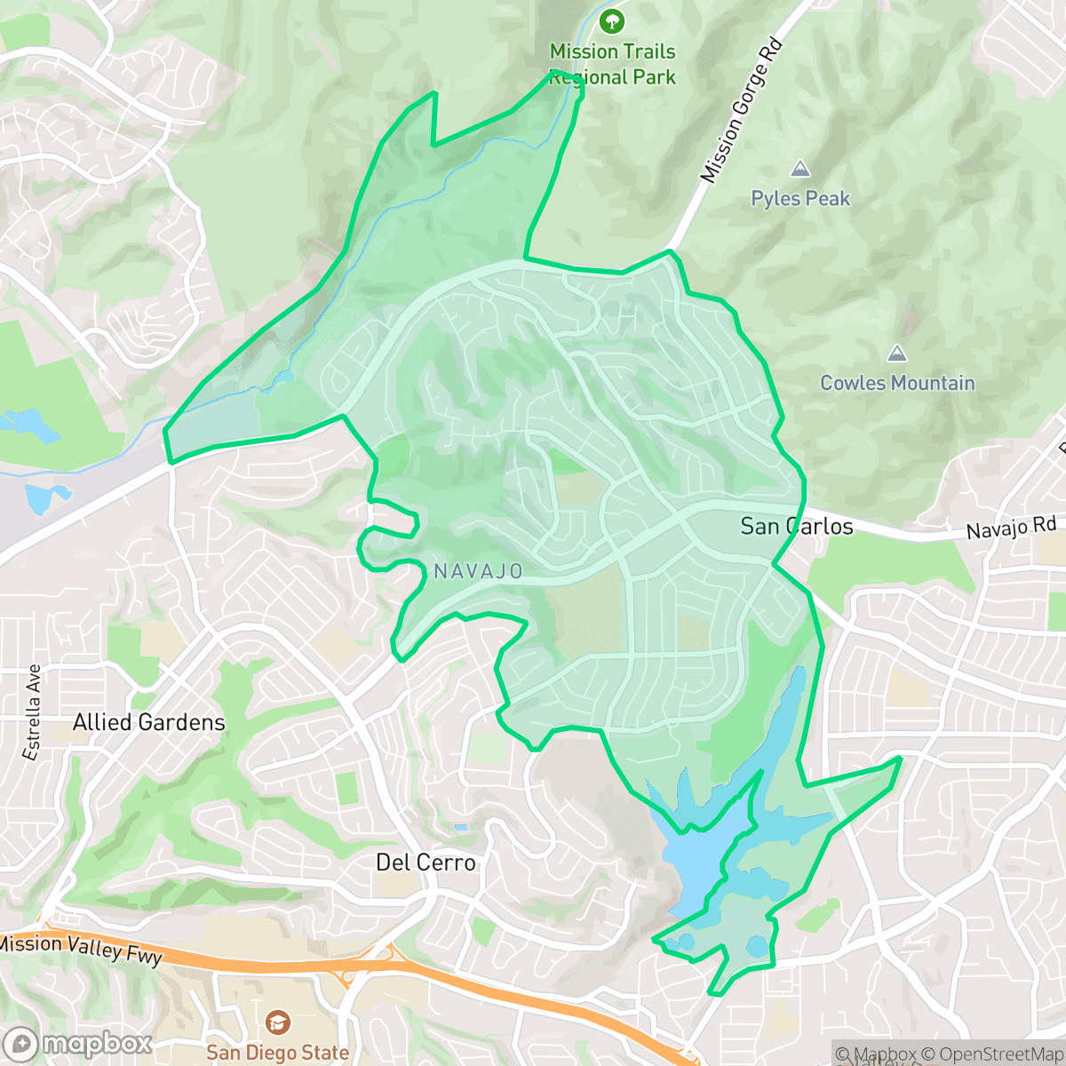
Developed starting in 1958 by the Tavares Development Company, the eastern San Diego neighborhood of San Carlos was named after its developer, Carlos Tavares (who also named nearby Clairemont for his wife, Claire). Primarily built out in the late 1960s and 1970s as a suburban tract-home community dominated by Ranch-style single-family homes, San Carlos is defined by its dramatic natural landmarks. It is home to Cowles Mountain, which at 1,592 feet is the highest point in the city of San Diego and a major trailhead for Mission Trails Regional Park. The neighborhood also borders Lake Murray, a historic reservoir whose current dam was completed in 1918. Navajo Road serves as the community's primary east-west thoroughfare, while Patrick Henry High School, opened in 1968, remains a central educational landmark.
The neighborhood is characterized by its dense suburban layout, featuring well-maintained single-family homes and a strong emphasis on outdoor recreation. Residents benefit from extensive sidewalk networks and proximity to large open spaces, which contribute to a high level of dog-friendliness and visual appeal. According to iHuus data, the area maintains a high rate of health insurance coverage and a stable, family-oriented atmosphere supported by top-performing local schools like Dailard and Green Elementary.
Prospective residents should consider certain trade-offs, including a heightened risk for fire safety and localized noise from road traffic along major thoroughfares. While the community offers a serene environment, the limited density of lifestyle businesses means that most social and retail needs require a vehicle. Additionally, some parts of the area are situated near industrial infrastructure, such as active quarries or utility facilities, which may impact acoustic comfort and air quality in specific blocks.
Neighborhood Scores Across 15 Qualities
Residential spacing varies between closely packed multi-family units and single-family homes with small setbacks. According to iHuus data, this level of separation provides more buffer between neighbors than is typical for the city of San Diego.
Continuous sidewalk networks and low-traffic residential loops facilitate safe pedestrian movement. This level of accessibility is consistent with the city average for San Diego.
Large homes with well-maintained landscaping and frequent private pools characterize this area, offering a visual quality that is higher than the San Diego average. According to iHuus data, the neighborhood features significant amounts of greenery and spacious residential lots.
Wide sidewalks, grassy verges, and nearby natural trails and lakes provide ample space for walking pets. This level of accessibility to green space and safe walking paths is higher than the San Diego average, according to iHuus data.
Significant natural canyons and open terrain provide a more open, semi-rural feel compared to the typical San Diego urban landscape. According to iHuus data, the area features a mix of residential tracts and undeveloped natural spaces.
Suburban blocks and scenic areas near the water provide a steady, low-key pace of life. This neighborhood feels slightly more subdued and less bustling than the San Diego average, offering a serene environment with a moderate mix of local dining and social hubs.
Frequent noise from nearby transit corridors and flight paths creates an audible disturbance. According to iHuus data, acoustic comfort in this area is on par with the San Diego city average.
Air quality fluctuates between acceptable and unhealthy levels, appearing slightly lower than the San Diego average according to iHuus data. Sensitive groups may experience occasional concern during certain periods.
Industrial presence is minimal, though an active quarry and utility facilities are located on the periphery of the neighborhood. This level of industrial proximity is slightly higher than the San Diego average according to iHuus data.
Health insurance access is widespread among residents, appearing significantly higher than the San Diego city average according to iHuus data.
Political leanings in this area are predominantly liberal, though the community follows a trend slightly more moderate than the San Diego average according to iHuus data.
A balanced mix of young adults, families, and older residents characterizes the area. This demographic spread is slightly more varied than the typical San Diego distribution, according to iHuus data.
Flood risk in this area is slightly above the San Diego average, though specific vulnerability levels remain undetermined due to a lack of detailed federal studies. According to iHuus data, the absence of a completed FEMA study means residents should exercise standard caution during heavy rain events.
High wildfire vulnerability characterizes this area, with fire safety levels significantly higher than the San Diego average. Residents should prioritize maximum protection measures and emergency preparedness due to this elevated hazard level.
Address-Level Insights for San Carlos


iHuus Neighborhood Intelligence Insights
Get address-level neighborhood insights for San Carlos
- Street-level scores — see how individual blocks compare, not just neighborhood averages
- Micro-zone boundaries — identify quiet pockets, flood boundaries, and walkable clusters before you visit
- 15 dimensions in full — walkability, noise, air quality, school quality, insurance coverage, population age profile, urban/rural index, and more
- Boundary risk alerts — know if your address sits near a block boundary where scores drop, the kind of detail no listing will ever mention
- School insights — individual school ratings and insights, not just district-level data
- Compare before you commit — side-by-side data across neighborhoods, down to block precision
No credit card required
Compare with Any Neighborhood
| Dimension | San Carlos | Adams North |
|---|---|---|
| 🚶 Walkabilityavg 8.58 | ||
| 🔊 Acoustic Comfortavg 3.33 | ||
| 🤫 Privacy Indexavg 4.87 | ||
| 🎨 Visual Appealavg 6.85 | ||
| 🐕 Dog Friendlinessavg 6.91 | ||
| 🗺️ Urban-Rural Indexavg 6.6 | ||
| ✨ Neighborhood Vibeavg 5.12 | ||
| 🏥 Health Insurance Coverageavg 7.53 | ||
| 🌿 Air Qualityavg 6.36 | ||
| 🏭 Industrial Proximityavg 9.12 | ||
| 🌊 Flood Safetyavg 4.2 | ||
| 🗳️ Ideological Leanavg 8.51 | ||
| 👥 Population Age Profileavg 4.8 | ||
| 🔥 Fire Safetyavg 0.61 | ||
| 🏫 School Quality |
San Carlos Rankings
School Districts Serving San Carlos
School Insights for San Carlos
Below average outcomes; significant attendance and academic challenges.
School Insights
See what's really behind every school rating near San Carlos
- Individual school ratings — each school's own score with outcome context, not just a district average
- Enrollment & class size data — student-to-teacher ratio and how it compares to the state average
- Full demographics breakdown — ethnicity and gender composition for every school in the enrollment zone
- Every school in the district — all schools within the enrollment boundary ranked by rating, not just the closest one
- Grade levels & benchmarks — elementary through high school, with below/above state-average flags
No credit card required