Cherokee Point, San Diego
Updated June 22, 2026 · 6,128 residents
Cherokee Point is a dense, highly walkable enclave in San Diego featuring a consistent grid of sidewalks and diverse local eateries. Residents benefit from a purely residential atmosphere free of heavy industry, though the area experiences significant noise from nearby highway traffic and limited privacy due to closely spaced housing.
Key Highlights
About Cherokee Point
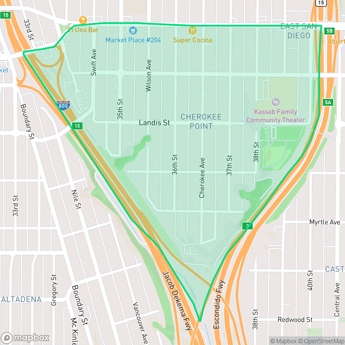
Cherokee Point is a historic, densely populated neighborhood in San Diego's City Heights area, with a residential history dating back to 1915. Nestled between Interstate 805 and Interstate 15, the neighborhood is uniquely shaped like a wine glass, with interior streets that converge to form the distinct outline of an arrowhead—a feature that inspired its name. The community's architectural character is defined by a mix of early 20th-century Craftsman cottages and Spanish Eclectic homes built during the 1920s and 1930s, interspersed with mid-century and modern multi-family developments. Cherokee Point is anchored by local landmarks such as Park de la Cruz and Cherokee Point Elementary School, which opened in 2005. Longstanding local businesses, including Canada Steak Burger, have anchored the neighborhood's commercial character for decades.
This neighborhood functions as a dense urban and suburban mix, characterized by a grid of narrow lots and multi-family housing. Beyond its unique street layout, the area offers a variety of local dining options, including authentic Salvadoran and Mexican establishments that contribute to its community character. According to iHuus data, the lack of heavy industrial activity ensures a purely residential and light commercial environment, maintaining a consistent focus on local living rather than commercial hubs. Residents benefit from excellent pedestrian infrastructure, making daily errands accessible without a vehicle. The area is best suited for individuals who prioritize walkability and proximity to diverse local culture over expansive private outdoor space or quiet acoustic conditions. Prospective residents should be aware that the high housing density results in limited privacy between neighbors. Furthermore, while the neighborhood is well-connected, the proximity to major highways results in elevated road traffic noise levels that remain a notable trade-off for those living in the area.
Neighborhood Scores Across 15 Qualities
Residential structures are positioned in very close quarters with minimal separation between property lines. According to iHuus data, this level of density is significantly lower than the San Diego average, meaning neighbors are often within just a few meters of one another.
Continuous sidewalks and clearly marked pedestrian crossings are present on nearly every street. This dense, grid-based layout offers superior pedestrian connectivity compared to the San Diego average.
Standard tract housing and mid-rise apartments define the landscape, featuring compact lots and uniform roof geometries. This area offers less visual variety and fewer private amenities than the San Diego average, according to iHuus data.
Public park access and grassy sidewalk verges are below the city average for San Diego. While some areas offer small green spaces and soccer fields, many parts of the neighborhood consist of dense residential blocks with minimal public greenery.
Open land and scattered dwellings provide a semi-rural feel that is very similar to the broader San Diego area. The landscape features a mix of suburban grids and pockets of woodland near major freeway corridors.
A mix of quiet residential blocks and social hubs provides a liveliness that is slightly above the San Diego average. While dining options like local coffee shops and pizzerias are available, the area remains primarily suburban with sparse walkable business density according to iHuus data.
Frequent noise from nearby freeway and railroad activity makes this area significantly louder than the San Diego average, according to iHuus data.
Air quality in this area fluctuates between acceptable and unhealthy levels, sitting slightly below the San Diego average. Sensitive groups may experience occasional respiratory concern on certain days, according to iHuus data.
Land use is exclusively residential and light commercial, with no warehouses or heavy industrial hazards detected. This area maintains a cleaner profile than the San Diego average according to iHuus data.
Health insurance access is notably lower in this area compared to the San Diego average, according to iHuus data.
Voting patterns and census indicators reflect a highly liberal political leaning that is more pronounced than the San Diego city average. According to iHuus data, the area shows a consistent trend toward progressive political alignment.
A varied demographic of young adults, families, and seniors resides here, representing a population age profile that is relatively similar to the San Diego average according to iHuus data.
Significant flood risk exists here due to the area's location within a 100-year floodplain. According to iHuus data, this risk is considerably higher than the San Diego average and often necessitates flood insurance.
Block-Level Insights for Cherokee Point

iHuus Neighborhood Intelligence Insights
Get block-level neighborhood insights for Cherokee Point
- Street-level scores — see how individual blocks compare, not just neighborhood averages
- Micro-zone boundaries — identify quiet pockets, flood boundaries, and walkable clusters before you visit
- 15 dimensions in full — walkability, noise, air quality, school quality, insurance coverage, population age profile, urban/rural index, and more
- Boundary risk alerts — know if your address sits near a block boundary where scores drop, the kind of detail no listing will ever mention
- School insights — individual school ratings and insights, not just district-level data
- Compare before you commit — side-by-side data across neighborhoods, down to block precision
No credit card required
Compare with Any Neighborhood
| Dimension | Cherokee Point | Adams North |
|---|---|---|
| 🚶 Walkabilityavg 8.58 | ||
| 🔊 Acoustic Comfortavg 3.33 | ||
| 🤫 Privacy Indexavg 4.87 | ||
| 🎨 Visual Appealavg 6.85 | ||
| 🐕 Dog Friendlinessavg 6.91 | ||
| 🗺️ Urban-Rural Indexavg 6.6 | ||
| ✨ Neighborhood Vibeavg 5.12 | ||
| 🏥 Health Insurance Coverageavg 7.53 | ||
| 🌿 Air Qualityavg 6.36 | ||
| 🏭 Industrial Proximityavg 9.12 | ||
| 🌊 Flood Safetyavg 4.2 | ||
| 🗳️ Ideological Leanavg 8.51 | ||
| 👥 Population Age Profileavg 4.8 | ||
| 🔥 Fire Safetyavg 0.61 | ||
| 🏫 School Quality |
Cherokee Point Rankings
School Districts Serving Cherokee Point
San Diego Unified is a district in transition, characterized by a mix of elite-performing clusters and significant pockets of academic distress. While recent gains in literacy, mathematics, and graduation rates—alongside multiple national awards—demonstrate strong educational potential, these successes are clouded by a $47 million budget deficit, declining enrollment, and labor instability resulting in a 2026 teacher strike. The district maintains high community trust in its 'destination' neighborhoods like La Jolla and Scripps Ranch, but significant equity gaps and financial pressures regarding special education funding prevent it from achieving a higher stability rating. It currently operates as a 'Mixed' district where high-quality outcomes are consistent in affluent clusters but systemic operational challenges remain unresolved.
Schools
School Insights for Cherokee Point
Below average outcomes; significant attendance and academic challenges.
School Insights
See what's really behind every school rating near Cherokee Point
- Individual school ratings — each school's own score with outcome context, not just a district average
- Enrollment & class size data — student-to-teacher ratio and how it compares to the state average
- Full demographics breakdown — ethnicity and gender composition for every school in the enrollment zone
- Every school in the district — all schools within the enrollment boundary ranked by rating, not just the closest one
- Grade levels & benchmarks — elementary through high school, with below/above state-average flags
No credit card required