Roseville Heights, Roseville
Updated June 22, 2026 · 3,719 residents
Roseville Heights is a historic neighborhood characterized by its dense, grid-based layout and proximity to active rail infrastructure. While the area offers a unique connection to local history and nearby parks, residents experience significant noise from rail operations and limited privacy due to closely spaced housing.
Key Highlights
About Roseville Heights
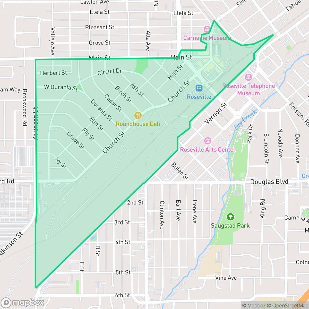
Roseville Heights in Roseville, California, is a historic neighborhood bounded by Atkinson, Main, and Vernon Streets. Its origins date back to 1906, when prominent pioneer rancher and landowner Elizabeth Jane Fiddyment subdivided part of her local landholdings into the Atkinson Tract, laying the groundwork for the modern neighborhood. Atkinson Street was named to perpetuate her memory. To accommodate the area's rapid early growth, local voters approved a bond issue in April 1910 to construct the Main Street School, one of Roseville's two original twin schoolhouses. Today, Roseville Heights retains its historic character, featuring a diverse mix of older architectural styles, mature trees, and close proximity to the landmarks of Historic Old Town Roseville and the 17-acre Royer Park.
The neighborhood maintains a distinct identity through its older architectural styles and established tree canopy. It serves as a central hub for those who value proximity to Historic Old Town and the recreational amenities of Royer Park. According to iHuus data, the area functions as a dense urban-suburban hybrid, characterized by small residential lots that reflect its early twentieth-century development patterns.
Prospective residents should note the influence of the adjacent rail yard, which contributes to elevated noise levels and restricts some pedestrian connectivity. While the community benefits from high-performing school districts and strong health insurance coverage, the dense housing layout results in limited private outdoor space. This area is best suited for individuals who prioritize a central location and historic charm over expansive private yards or total acoustic seclusion.
Neighborhood Scores Across 15 Qualities
Residential structures are often closely spaced with small setbacks, resulting in less privacy than the Roseville average. According to iHuus data, some areas feature high-density layouts where houses sit quite near one another.
Sidewalks are available on many residential streets and crossings are generally safe, though a large rail corridor creates a notable barrier for pedestrians. This level of connectivity is lower than the average seen across Roseville.
Standard tract housing dominates the landscape with small yards and dense lot spacing. This area features less visual variety and fewer luxury amenities compared to the Roseville average, according to iHuus data.
Walking opportunities for pets are below the city average due to narrow sidewalk verges and the presence of large, restricted industrial rail yards. While some areas offer grassy edges and proximity to the Roebbelen Center grounds, much of the greenery remains within private yards.
Residential pockets feature a dense suburban layout with single-family homes, though industrial rail yards and large commercial centers contribute to a landscape that is slightly less open than the Roseville average, according to iHuus data.
A balanced mix of light industrial units, green spaces, and diverse dining options provides a consistent but low-key energy. This level of activity is consistent with the overall city average.
Local traffic from a nearby busy street creates a consistent level of ambient noise. This acoustic environment is slightly more active than the average found throughout Roseville.
Air quality in this area fluctuates between acceptable and unhealthy levels. According to iHuus data, these conditions are consistent with the typical levels found across Roseville.
Active rail yards, logistics hubs, and large commercial centers introduce notable levels of truck traffic and noise. This presence of light industrial and warehouse activity is more significant here than in most other parts of Roseville.
Health insurance enrollment in this area is lower than the average seen across Roseville. According to iHuus data, a significant portion of the resident population remains uninsured.
Political views in this area are split relatively evenly, presenting a more moderate landscape than the more conservative lean found across much of Roseville. According to iHuus data, the neighborhood lacks a dominant partisan tilt.
A balanced mix of young adults, families, and older residents characterizes the community. According to iHuus data, this demographic spread is slightly more concentrated toward specific age groups than the broader Roseville average.
Flood risk in this area remains uncertain because FEMA has not completed a detailed study for this specific zone. According to iHuus data, the level of safety from flooding is lower than the Roseville average.
Block-Level Insights for Roseville Heights

iHuus Neighborhood Intelligence Insights
Get block-level neighborhood insights for Roseville Heights
- Street-level scores — see how individual blocks compare, not just neighborhood averages
- Micro-zone boundaries — identify quiet pockets, flood boundaries, and walkable clusters before you visit
- 15 dimensions in full — walkability, noise, air quality, school quality, insurance coverage, population age profile, urban/rural index, and more
- Boundary risk alerts — know if your address sits near a block boundary where scores drop, the kind of detail no listing will ever mention
- School insights — individual school ratings and insights, not just district-level data
- Compare before you commit — side-by-side data across neighborhoods, down to block precision
No credit card required
Compare with Any Neighborhood
| Dimension | Roseville Heights | Blue Oaks |
|---|---|---|
| 🚶 Walkabilityavg 8.87 | ||
| 🔊 Acoustic Comfortavg 4.32 | ||
| 🤫 Privacy Indexavg 5.7 | ||
| 🎨 Visual Appealavg 7.58 | ||
| 🐕 Dog Friendlinessavg 7.74 | ||
| 🗺️ Urban-Rural Indexavg 6.82 | ||
| ✨ Neighborhood Vibeavg 4.77 | ||
| 🏥 Health Insurance Coverageavg 8.58 | ||
| 🌿 Air Qualityavg 6 | ||
| 🏭 Industrial Proximityavg 8.8 | ||
| 🌊 Flood Safetyavg 5.72 | ||
| 🗳️ Ideological Leanavg 3.68 | ||
| 👥 Population Age Profileavg 5.05 | ||
| 🔥 Fire Safetyavg 0.15 | ||
| 🏫 School Quality |
Roseville Heights Rankings
School Districts Serving Roseville Heights
Roseville Joint Union High School District is a high-performing 'Blue Chip' organization exhibiting strong academic consistency and operational excellence. The district's portfolio is anchored by elite terminal high schools like Granite Bay and modern facilities like West Park, supported by proactive investments in both Career Technical Education and student mental health infrastructure. While navigating rapid regional growth and the pressures of a high-achievement culture, the district maintains deep community trust, evidenced by successful facility expansions and positive sentiment across diverse educational pathways. Aside from a single continuation school outlier, the district demonstrates the stability, financial health, and academic rigor characteristic of a top-tier educational agency.
Schools
Roseville City Elementary School District is a high-performing, financially stable organization characterized by strong community trust and academic proficiency that significantly exceeds state benchmarks. While the district's portfolio contains a wide performance gap between its top-tier neighborhood schools (rated 8-10) and its struggling campuses (rated 2-3), it maintains a high degree of operational excellence through proactive facility expansion, successful bond management, and robust arts and mental health programming. Current challenges are primarily environmental, driven by rapid population growth in West Roseville leading to student overflows and capacity debates, yet the district remains a top-tier regional choice with a stable leadership outlook.
Schools
School Insights for Roseville Heights
Below average outcomes; significant attendance and academic challenges.
School Insights
See what's really behind every school rating near Roseville Heights
- Individual school ratings — each school's own score with outcome context, not just a district average
- Enrollment & class size data — student-to-teacher ratio and how it compares to the state average
- Full demographics breakdown — ethnicity and gender composition for every school in the enrollment zone
- Every school in the district — all schools within the enrollment boundary ranked by rating, not just the closest one
- Grade levels & benchmarks — elementary through high school, with below/above state-average flags
No credit card required