Airport, Riverside
Updated June 22, 2026 · 13,539 residents
The Airport neighborhood in Riverside is defined by its namesake aviation hub and a blend of suburban residential tracts and industrial logistics centers. While it offers a quiet, low-density environment with private backyard space, the area experiences significant road noise and is physically segmented by large-scale commercial infrastructure.
Key Highlights
About Airport
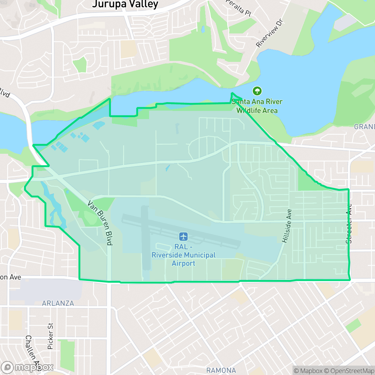
The Airport neighborhood in Riverside, California, is anchored by the Riverside Municipal Airport, which was originally established in the 1920s as Arlington Airport before its acquisition by the city in 1953. Bounded by Central Avenue, Arlington Avenue, Hillside Avenue, and Van Buren Boulevard, the neighborhood developed around this aviation hub, which now hosts California Baptist University’s aviation science program and the Civil Air Patrol Senior Squadron 5. A key community gathering space is Nichols Park, which offers recreational space for local families. The neighborhood's contemporary character is also defined by local businesses such as the Packinghouse Brewing Company and long-standing eateries along Arlington Avenue.
The neighborhood functions as a distinct suburban enclave that balances residential living with significant industrial and aviation activity. Its landscape is characterized by a mix of standard tract housing and massive logistics hubs, creating a unique environment where quiet residential streets sit adjacent to active freight corridors. According to iHuus data, the area maintains a steady, low-key rhythm, offering residents a sense of privacy through detached homes and fenced yards.
Living in this area requires a trade-off between suburban privacy and limited pedestrian accessibility. While the neighborhood provides ample space and individual property amenities, the presence of large warehouses and major roadways creates physical barriers that make walking to local services difficult. It is best suited for those who value a quiet, car-dependent environment and do not mind the proximity to industrial and transit infrastructure.
Neighborhood Scores Across 15 Qualities
Housing layouts vary between closely packed townhomes with shared walls and detached suburban homes with modest yard spacing. This level of density is roughly average for Riverside according to iHuus data.
Residential streets feature consistent sidewalks and safe crossings, though large parking lots and industrial zones can create occasional barriers. This level of pedestrian connectivity is slightly lower than the Riverside city average.
Residential landscapes feature a mix of standard tract housing and larger homes with private pools. According to iHuus data, the visual variety and upscale amenities in this area are slightly below the Riverside average.
Walking opportunities for pets are inconsistent across the area due to a lack of large public parks, which is below the Riverside average. While some sections offer access to sports fields and trail areas, much of the greenery is confined to private yards or narrow roadside strips.
Residential tracts and apartment complexes exist alongside large-scale industrial warehouses and an active airport runway. This area feels slightly more urban than the Riverside average due to the dense mix of utility zones and commercial infrastructure.
Predominantly industrial and suburban in character, this area offers a calm atmosphere with limited commercial activity. Residents will find fewer social destinations or retail options compared to the city average, making car travel necessary for most errands.
Local traffic from a nearby busy street creates a consistent hum; this level of noise is roughly comparable to the city average according to iHuus data.
Air quality remains consistently good with only rare instances of elevated readings. This level of air cleanliness is nearly identical to the Riverside average, according to iHuus data.
Large logistics warehouses, a wastewater treatment plant, and an active airport runway introduce notable noise and traffic near certain residential pockets. While many areas remain primarily residential, the presence of heavy vehicle docks and industrial storage makes industrial proximity slightly higher than the Riverside average, according to iHuus data.
Health insurance accessibility is lower than the Riverside average. According to iHuus data, fewer residents in this area have active coverage compared to the rest of the city.
Political leanings in this area tend toward liberal values, appearing more progressive than the Riverside average according to iHuus data.
Residents live alongside a balanced mix of young adults, families, and older populations. This age distribution is consistent with the broader Riverside area, according to iHuus data.
Flood risk is significantly higher than the Riverside average due to the area's proximity to hazard zones. Residents should prepare for elevated or potentially prohibitive insurance costs according to iHuus data.
Fire hazards in this area are exceptionally high, representing a greater risk than the Riverside average. Residents should prepare for extreme fire safety requirements according to iHuus data.
Block-Level Insights for Airport

iHuus Neighborhood Intelligence Insights
Get block-level neighborhood insights for Airport
- Street-level scores — see how individual blocks compare, not just neighborhood averages
- Micro-zone boundaries — identify quiet pockets, flood boundaries, and walkable clusters before you visit
- 15 dimensions in full — walkability, noise, air quality, school quality, insurance coverage, population age profile, urban/rural index, and more
- Boundary risk alerts — know if your address sits near a block boundary where scores drop, the kind of detail no listing will ever mention
- School insights — individual school ratings and insights, not just district-level data
- Compare before you commit — side-by-side data across neighborhoods, down to block precision
No credit card required
Compare with Any Neighborhood
| Dimension | Airport | Alessandro Heights |
|---|---|---|
| 🚶 Walkabilityavg 7.91 | ||
| 🔊 Acoustic Comfortavg 4.28 | ||
| 🤫 Privacy Indexavg 5.41 | ||
| 🎨 Visual Appealavg 6.73 | ||
| 🐕 Dog Friendlinessavg 6.29 | ||
| 🗺️ Urban-Rural Indexavg 7.07 | ||
| ✨ Neighborhood Vibeavg 4.37 | ||
| 🏥 Health Insurance Coverageavg 6.35 | ||
| 🌿 Air Qualityavg 8.25 | ||
| 🏭 Industrial Proximityavg 8.09 | ||
| 🌊 Flood Safetyavg 1.24 | ||
| 🗳️ Ideological Leanavg 7.01 | ||
| 👥 Population Age Profileavg 4.57 | ||
| 🔥 Fire Safetyavg 0.35 | ||
| 🏫 School Quality |
Airport Rankings
School Districts Serving Airport
Alvord Unified School District is a mixed-performance system characterized by a notable achievement gap between its high-performing secondary schools and a significant number of struggling elementary and middle schools. While the district maintains strong community support through award-winning extracurricular programs, dedicated teaching staff, and proactive safety communication, it faces persistent challenges with math proficiency and aging infrastructure. High graduation rates and competitive college placements for top-tier students provide stability, but the high density of low-rated schools (under 3/10) prevents a higher rating, placing the district in a transitional state between operational distress and solid academic standing.
Schools
Jurupa Unified School District functions as a stable, well-funded 'Community School' model district that struggles with deep-seated academic proficiency gaps, particularly at the middle school level where all sites are underperforming. While state testing scores in math and English are significantly below par, the district compensates with exceptional graduation rates (94.1%), award-winning CTE programs, and strong community trust as evidenced by successful bond measures and grant acquisitions. The district operates with high organizational stability and a clear strategic focus on student wellness and safety, making it a solid '3'—a district in transition that provides a safe and supportive environment despite lagging behind in core academic metrics.
Schools
Riverside Unified is a stable, mid-tier district characterized by robust specialized programs, such as its Dual Language Immersion and International Baccalaureate pathways, alongside significant internal performance disparities. While the district maintains financial trust through successful bond measures and has avoided the enrollment cliffs seen elsewhere in California, it struggles with a sharp divide between its high-performing southern schools and distressed campuses in older neighborhoods. Current investments in AI-driven security and Career Technical Education (CTE) demonstrate forward-looking management, yet persistent gaps in math proficiency and special education communication keep the district in a 'Mixed/Transition' status.
Schools
School Insights for Airport
Below average outcomes; significant attendance and academic challenges.
School Insights
See what's really behind every school rating near Airport
- Individual school ratings — each school's own score with outcome context, not just a district average
- Enrollment & class size data — student-to-teacher ratio and how it compares to the state average
- Full demographics breakdown — ethnicity and gender composition for every school in the enrollment zone
- Every school in the district — all schools within the enrollment boundary ranked by rating, not just the closest one
- Grade levels & benchmarks — elementary through high school, with below/above state-average flags
No credit card required