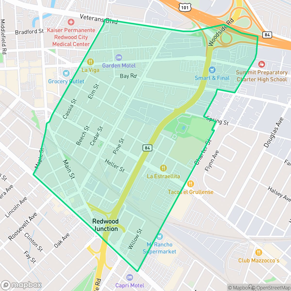
Middlefield, Redwood City
Updated June 22, 2026 · 5,926 residents
Middlefield is a dense, urban neighborhood in Redwood City characterized by a mix of residential blocks, commercial warehouses, and significant industrial infrastructure. While the area offers convenient access to local dining and a functional grid-based street layout, residents must contend with high levels of road noise and limited public green space.
Key Highlights
About Middlefield
Located in a busy corridor of Redwood City, this neighborhood serves as a practical, high-density environment defined by its proximity to major transit routes and industrial zones. The landscape consists of standard tract housing and mid-sized apartment complexes interspersed with large-scale logistics centers and commercial warehouses. Residents benefit from a consistent sidewalk network that supports local travel, though the area is notably influenced by its industrial surroundings and the constant hum of nearby freeway traffic. The local dining scene provides some variety, with several small eateries and markets contributing to the neighborhood's functional, urban character.
Living in this area requires balancing the convenience of a central location against specific trade-offs regarding acoustic comfort and privacy. With a high volume of road traffic and limited public parks, the environment is best suited for those who prioritize accessibility and proximity to major thoroughfares over quiet, suburban seclusion. Prospective residents should be aware of the dense building layout and the industrial nature of the immediate surroundings, which shape the daily experience of living in this part of the city.
Neighborhood Scores Across 15 Qualities
Residential structures and buildings are positioned in close proximity with minimal separation between properties. According to iHuus data, this level of density is notably higher than the Redwood City average, resulting in limited setbacks between neighbors.
Residential streets offer a consistent sidewalk grid and safe crossings, though large industrial blocks and a major rail corridor can disrupt continuous walking paths. According to iHuus data, walkability in this area is slightly below the Redwood City average.
Standard tract housing and apartment complexes characterize this area, featuring functional architecture and modest yards. The visual variety is slightly lower than the Redwood City average due to the prevalence of rectangular rooftops and high lot coverage.
Public park access and green verges are sparse in this area, making it less dog-friendly than the Redwood City average. While some residents benefit from nearby sports fields, most greenery is confined to private backyards.
Residential streets and green spaces exist in equal measure with industrial and commercial zones. This balance of built environment and open space is slightly less dense than the Redwood City average, according to iHuus data.
Diverse dining options and social hubs like Hoover Park provide more activity than the typical Redwood City neighborhood. While various pockets offer lively atmospheres, much of the area remains car-dependent due to the presence of industrial blocks and highway-adjacent streets.
Frequent noise from nearby railroad tracks and major freeways characterizes this area. According to iHuus data, acoustic comfort is significantly lower than the Redwood City average.
Air quality in this area is generally good, with only rare instances of elevated readings. According to iHuus data, the air quality remains slightly better than the Redwood City average.
Large warehouses and logistics hubs with frequent truck traffic border parts of the neighborhood. This presence of commercial loading zones and rail lines is notably higher than the Redwood City average.
Health insurance access is notably lower in Middlefield than in the rest of Redwood City, according to iHuus data.
Voting patterns and census indicators show a predominantly liberal community, which aligns closely with the broader political landscape of Redwood City.
Residents live alongside a balanced variety of age groups, ranging from young adults to older adults. This demographic spread is slightly more varied than the typical profile found across Redwood City.
Significant flood risk exists here because portions of the area fall within a designated floodplain. According to iHuus data, this level of vulnerability is much higher than the Redwood City average and may necessitate flood insurance.
Block-Level Insights for Middlefield

iHuus Neighborhood Intelligence Insights
Get block-level neighborhood insights for Middlefield
- Street-level scores — see how individual blocks compare, not just neighborhood averages
- Micro-zone boundaries — identify quiet pockets, flood boundaries, and walkable clusters before you visit
- 15 dimensions in full — walkability, noise, air quality, school quality, insurance coverage, population age profile, urban/rural index, and more
- Boundary risk alerts — know if your address sits near a block boundary where scores drop, the kind of detail no listing will ever mention
- School insights — individual school ratings and insights, not just district-level data
- Compare before you commit — side-by-side data across neighborhoods, down to block precision
No credit card required
Compare with Any Neighborhood
| Dimension | Middlefield | Ampex |
|---|---|---|
| 🚶 Walkabilityavg 8.4 | ||
| 🔊 Acoustic Comfortavg 4.29 | ||
| 🤫 Privacy Indexavg 4.9 | ||
| 🎨 Visual Appealavg 7 | ||
| 🐕 Dog Friendlinessavg 6.12 | ||
| 🗺️ Urban-Rural Indexavg 6.63 | ||
| ✨ Neighborhood Vibeavg 4.41 | ||
| 🏥 Health Insurance Coverageavg 7.97 | ||
| 🌿 Air Qualityavg 6.23 | ||
| 🏭 Industrial Proximityavg 8.38 | ||
| 🌊 Flood Safetyavg 4.84 | ||
| 🗳️ Ideological Leanavg 9.73 | ||
| 👥 Population Age Profileavg 4.84 | ||
| 🔥 Fire Safetyavg 0.22 | ||
| 🏫 School Quality |
Middlefield Rankings
School Districts Serving Middlefield
Redwood City Elementary School District functions as a stable but bifurcated organization characterized by high-quality teaching staff and strong community engagement, yet weighed down by significant fiscal and enrollment headwinds. While facilities are seeing modern upgrades through voter-approved bonds, the district is currently navigating a period of contraction, marked by multi-million dollar budget cuts, staff attrition, and increasing class sizes that have sparked tension with the labor union. Academically, the portfolio ranges from elite, high-demand schools to underperforming campuses, resulting in a district that offers excellent opportunities for those in specific programs but faces systemic challenges in elevating overall proficiency across its diverse student body.
Schools
Sequoia Union High School District remains an academic powerhouse with high-performing flagship schools like Carlmont and Menlo-Atherton consistently outpacing state standards; however, it is currently in a state of operational transition and controversy. The district faces significant community backlash following the decision to close the newly built TIDE Academy to address a $6 million deficit, alongside parent concerns regarding the removal of honors-level 'bridge' courses for younger students. While the core academic portfolio is robust, recent lawsuits involving staff misconduct and ongoing debates over curriculum equity and fiscal management signal internal instability that offsets its high-ranking test scores.
Schools
School Insights for Middlefield
Below average outcomes; significant attendance and academic challenges.
School Insights
See what's really behind every school rating near Middlefield
- Individual school ratings — each school's own score with outcome context, not just a district average
- Enrollment & class size data — student-to-teacher ratio and how it compares to the state average
- Full demographics breakdown — ethnicity and gender composition for every school in the enrollment zone
- Every school in the district — all schools within the enrollment boundary ranked by rating, not just the closest one
- Grade levels & benchmarks — elementary through high school, with below/above state-average flags
No credit card required