Monroe Park, Palo Alto
Updated June 22, 2026 · 688 residents
Monroe Park is an exceptionally walkable neighborhood on the Palo Alto-Mountain View border that offers residents immediate access to diverse dining and social hubs. While the area provides a dense suburban environment with proximity to top-tier school districts, it experiences significant noise levels from road traffic and faces specific environmental considerations regarding local land use.
Key Highlights
About Monroe Park
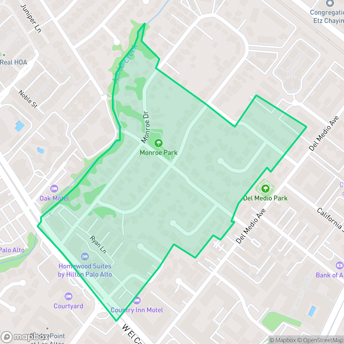
Monroe Park, a neighborhood on the Palo Alto-Mountain View border, is named after Monroe Drive, which honors L.G. Monroe, the original owner of the tract developed into the Monroe Park subdivision. At its heart is the 0.55-acre Monroe Park, established in 1975 with early plans to connect the area to the rest of the city via a pedestrian bridge over Adobe Creek. Architecturally, the neighborhood features a notable piece of local history: a Queen Anne and Eastlake-style vernacular cottage built in 1899 by Danish carpenter Anton Jensen. Originally located on Homer Avenue, where it housed early Chinese-American families like the Mocks and Satos, the historic home was saved from demolition in July 1985 and relocated to 449 Monroe Drive, where it was subsequently rehabilitated.
The area is defined by its high walkability and proximity to essential amenities, including popular eateries like Noodle Talk and Mendocino Farms. It serves as a dense suburban enclave that balances residential living with convenient access to commercial hubs. According to iHuus data, the neighborhood features a mix of standard tract housing and larger apartment complexes, creating a varied residential landscape that caters to those prioritizing accessibility over quiet isolation.
Potential residents should be aware of the trade-offs associated with this location. The neighborhood experiences high levels of ambient noise primarily driven by nearby road traffic, and the proximity to an EPA Superfund site requires attention to environmental factors. Despite these challenges, the area remains a draw for families seeking access to elite educational institutions within the Los Altos, Mountain View-Los Altos, and Palo Alto Unified school districts. It is best suited for individuals who value a high-energy, pedestrian-friendly lifestyle in the heart of the Silicon Valley corridor.
Neighborhood Scores Across 15 Qualities
Residential spacing is consistent with the Palo Alto average, featuring a mix of single-family homes and multi-unit complexes. Properties typically maintain a moderate buffer between neighbors, providing a balanced level of privacy.
Pedestrian access is exceptionally convenient due to continuous sidewalks on both sides of residential and arterial roads. According to iHuus data, the network of clear crosswalks and low traffic cul-de-sacs provides a level of safety and connectivity that is higher than the Palo Alto average.
Manicured yards and large properties with private amenities characterize this area, though the overall visual quality sits slightly below the Palo Alto average according to iHuus data.
Spacious parks and wide residential parkways provide ample room for walking dogs. Accessible green verges and nearby public parks offer significant space for pets, though overall accessibility is slightly below the Palo Alto average.
Residential layouts consist of single-family homes interspersed with mid-size apartment complexes and a large sports complex. This suburban density is largely comparable to the broader Palo Alto area according to iHuus data.
Local streets offer a balanced mix of residential quiet and accessible dining, maintaining a level of activity that is very similar to the Palo Alto average. While some blocks feature dense social hubs and diverse eateries, many parts of the neighborhood remain calm and suburban in character.
Persistent noise from nearby airport runways and heavy rail infrastructure makes this area significantly noisier than the Palo Alto average. According to iHuus data, acoustic comfort is minimal due to the immediate proximity of high-traffic transportation corridors.
Air quality in this area fluctuates between acceptable and unhealthy levels on certain days. According to iHuus data, these conditions are consistent with the average found throughout Palo Alto.
Presence of a nearby EPA Superfund site may pose risks of soil or groundwater contamination. This neighborhood features a higher level of industrial proximity than the Palo Alto average.
Health insurance enrollment is exceptionally high among residents, remaining well above the Palo Alto average according to iHuus data.
Voting patterns and census indicators reflect a strongly liberal political leaning that is slightly more pronounced than the Palo Alto city average.
Residents live among a diverse mix of young adults, families, and seniors. This age distribution is roughly in line with the Palo Alto average.
Flood risk in this area is higher than the Palo Alto average, though specific risk levels remain uncertain because a detailed federal study has not yet been completed. According to iHuus data, the area lacks a definitive classification for flood hazards.
Block-Level Insights for Monroe Park

iHuus Neighborhood Intelligence Insights
Get block-level neighborhood insights for Monroe Park
- Street-level scores — see how individual blocks compare, not just neighborhood averages
- Micro-zone boundaries — identify quiet pockets, flood boundaries, and walkable clusters before you visit
- 15 dimensions in full — walkability, noise, air quality, school quality, insurance coverage, population age profile, urban/rural index, and more
- Boundary risk alerts — know if your address sits near a block boundary where scores drop, the kind of detail no listing will ever mention
- School insights — individual school ratings and insights, not just district-level data
- Compare before you commit — side-by-side data across neighborhoods, down to block precision
No credit card required
Compare with Any Neighborhood
| Dimension | Monroe Park | Adobe Meadow - Meadow Park |
|---|---|---|
| 🚶 Walkabilityavg 8.94 | ||
| 🔊 Acoustic Comfortavg 3.51 | ||
| 🤫 Privacy Indexavg 5.96 | ||
| 🎨 Visual Appealavg 7.97 | ||
| 🐕 Dog Friendlinessavg 7.6 | ||
| 🗺️ Urban-Rural Indexavg 6.74 | ||
| ✨ Neighborhood Vibeavg 4.82 | ||
| 🏥 Health Insurance Coverageavg 9.05 | ||
| 🌿 Air Qualityavg 6.03 | ||
| 🏭 Industrial Proximityavg 8.67 | ||
| 🌊 Flood Safetyavg 3.52 | ||
| 🗳️ Ideological Leanavg 9.81 | ||
| 👥 Population Age Profileavg 5.03 | ||
| 🔥 Fire Safety | ||
| 🏫 School Quality |
Monroe Park Rankings
School Districts Serving Monroe Park
Los Altos Elementary School District is a premier 'Blue Chip' organization characterized by elite academic performance, robust community financial backing, and significant operational stability. With 89% math proficiency and consistent 10/10 school ratings, the district remains a top-tier California performer despite regional cost-of-living pressures and minor enrollment declines. The recent resolution of facility sharing agreements with Bullis Charter School further solidifies its stability, while record-breaking private foundations ensure specialized programs remain better funded than state averages, making it a definitive destination district.
Schools
MVLA is a 'Blue Chip' district characterized by elite academic performance, financial transparency, and modern facility infrastructure. Its terminal high schools are national leaders in STEM and college readiness, supported by a stable tax base and successful local bond measures. While the district faces community debate over curriculum modernization and high-pressure environments, its proactive investment in wellness centers and sustained 'Green' financial audits indicate a highly stable and well-managed organization that remains a primary draw for the region.
Schools
Palo Alto Unified School District is an elite, financially robust 'Blue Chip' district characterized by universal academic excellence across all 19 campuses. Operating as a basic aid district, PAUSD maintains superior infrastructure and extracurricular offerings that rival private institutions, attracting top-tier educators and high-achieving families. While the district faces localized challenges regarding the intense academic culture at its high schools and the high cost of living for staff, its administrative stability, proactive curriculum enhancements, and exceptional college readiness metrics solidify its position as a national leader in public education.
Schools
School Insights for Monroe Park
Below average outcomes; significant attendance and academic challenges.
School Insights
See what's really behind every school rating near Monroe Park
- Individual school ratings — each school's own score with outcome context, not just a district average
- Enrollment & class size data — student-to-teacher ratio and how it compares to the state average
- Full demographics breakdown — ethnicity and gender composition for every school in the enrollment zone
- Every school in the district — all schools within the enrollment boundary ranked by rating, not just the closest one
- Grade levels & benchmarks — elementary through high school, with below/above state-average flags
No credit card required