Leland Manor, Palo Alto
Updated June 22, 2026 · 561 residents
Leland Manor is a quiet, highly walkable residential enclave in Palo Alto known for its expansive mid-century ranch homes and tree-lined streets. While the area offers exceptional access to elite public schools and a serene atmosphere, residents should note that road traffic contributes to moderate noise levels in some parts of the community.
Key Highlights
About Leland Manor
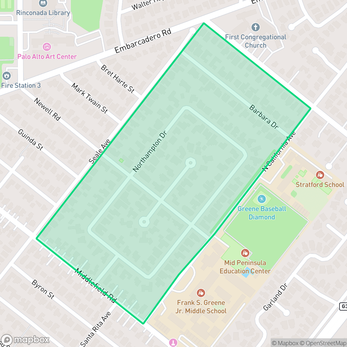
Established in 1939 and annexed into Palo Alto during that decade, the Leland Manor neighborhood is a tranquil community renowned for its early mid-century California design. From its inception, the development was highly unusual and forward-thinking for placing all of its electric and telephone lines underground to eliminate "unsightly poles". Architecturally, Leland Manor is characterized by spacious ranch-style homes situated on large 9,000- to 10,000-square-foot lots. The neighborhood gained significant regional attention when a home on Newell Road served as a model home for the 1939 San Francisco Golden Gate International Exposition, drawing over 25,000 visitors. Symmetrically divided by Newell Road, the neighborhood's lack of through traffic and wireless streets continue to preserve its peaceful, suburban character.
The neighborhood is a predominantly residential area characterized by spacious lots and a strong sense of community. It maintains a consistent architectural aesthetic, with wide streets and ample green space that contribute to its high visual appeal and walkability. Residents benefit from being part of the Palo Alto Unified School District, which is recognized for its academic excellence and robust infrastructure. The area is best suited for families and professionals seeking a tranquil, suburban environment with proximity to urban amenities. While the neighborhood is peaceful, the proximity to arterial roads results in a moderate noise level of 61 decibels. Prospective residents should also be aware of local environmental factors, as the area faces significant challenges regarding flood and fire safety.
Neighborhood Scores Across 15 Qualities
Standard suburban spacing and mature trees provide consistent visual buffers between adjacent properties. This level of separation is typical for the Palo Alto area.
Low-traffic residential cul-de-sacs and a reliable sidewalk network make much of the area easy to navigate on foot. This level of walkability is slightly below the Palo Alto average, though mature tree canopies provide shaded paths for residents.
Large homes, private pools, and high-quality landscaping characterize the local landscape. This level of visual polish is consistent with the broader Palo Alto average.
Wide paths and green verges between sidewalks and roads provide safe movement for pets. Proximity to local parks and ballfields makes this area slightly below the Palo Alto average for dog friendliness according to iHuus data.
Residential areas feature a dense suburban pattern of single-family homes and some multi-unit complexes near the highway. This landscape is slightly more developed than the typical semi-rural character found elsewhere in Palo Alto, according to iHuus data.
Residential life here is peaceful and low-key, with a lower level of commercial activity and social density than the Palo Alto average. Local amenities are sparse, consisting primarily of a few nearby services and small-scale eateries within a largely green, suburban landscape.
Local traffic from a nearby busy street creates a consistent level of noise, though this is more tranquil than the city average.
Air quality in this area fluctuates between acceptable and unhealthy levels, matching the general average for Palo Alto. Sensitive groups should remain mindful of occasional periods of concern according to iHuus data.
Industrial activity and warehouse facilities are entirely absent from this area. According to iHuus data, the neighborhood is exclusively residential and light commercial, providing a cleaner environment than the Palo Alto average.
Health insurance access is nearly universal among residents; this rate is slightly above the Palo Alto average according to iHuus data.
Voting patterns and census indicators show a strongly liberal political leaning that is consistent with the broader Palo Alto area.
Residents live alongside a diverse range of age groups, from young professionals to seniors. This demographic spread is largely in line with the broader Palo Alto area.
Flood risk is significantly higher than the Palo Alto average because portions of the area fall within a designated floodplain. Residents should be aware that flood insurance is typically required for properties in this zone, according to iHuus data.
Block-Level Insights for Leland Manor

iHuus Neighborhood Intelligence Insights
Get block-level neighborhood insights for Leland Manor
- Street-level scores — see how individual blocks compare, not just neighborhood averages
- Micro-zone boundaries — identify quiet pockets, flood boundaries, and walkable clusters before you visit
- 15 dimensions in full — walkability, noise, air quality, school quality, insurance coverage, population age profile, urban/rural index, and more
- Boundary risk alerts — know if your address sits near a block boundary where scores drop, the kind of detail no listing will ever mention
- School insights — individual school ratings and insights, not just district-level data
- Compare before you commit — side-by-side data across neighborhoods, down to block precision
No credit card required
Compare with Any Neighborhood
| Dimension | Leland Manor | Adobe Meadow - Meadow Park |
|---|---|---|
| 🚶 Walkabilityavg 8.94 | ||
| 🔊 Acoustic Comfortavg 3.51 | ||
| 🤫 Privacy Indexavg 5.96 | ||
| 🎨 Visual Appealavg 7.97 | ||
| 🐕 Dog Friendlinessavg 7.6 | ||
| 🗺️ Urban-Rural Indexavg 6.74 | ||
| ✨ Neighborhood Vibeavg 4.82 | ||
| 🏥 Health Insurance Coverageavg 9.05 | ||
| 🌿 Air Qualityavg 6.03 | ||
| 🏭 Industrial Proximityavg 8.67 | ||
| 🌊 Flood Safetyavg 3.52 | ||
| 🗳️ Ideological Leanavg 9.81 | ||
| 👥 Population Age Profileavg 5.03 | ||
| 🔥 Fire Safety | ||
| 🏫 School Quality |
Leland Manor Rankings
School Districts Serving Leland Manor
Palo Alto Unified School District is an elite, financially robust 'Blue Chip' district characterized by universal academic excellence across all 19 campuses. Operating as a basic aid district, PAUSD maintains superior infrastructure and extracurricular offerings that rival private institutions, attracting top-tier educators and high-achieving families. While the district faces localized challenges regarding the intense academic culture at its high schools and the high cost of living for staff, its administrative stability, proactive curriculum enhancements, and exceptional college readiness metrics solidify its position as a national leader in public education.
Schools
School Insights for Leland Manor
Below average outcomes; significant attendance and academic challenges.
School Insights
See what's really behind every school rating near Leland Manor
- Individual school ratings — each school's own score with outcome context, not just a district average
- Enrollment & class size data — student-to-teacher ratio and how it compares to the state average
- Full demographics breakdown — ethnicity and gender composition for every school in the enrollment zone
- Every school in the district — all schools within the enrollment boundary ranked by rating, not just the closest one
- Grade levels & benchmarks — elementary through high school, with below/above state-average flags
No credit card required