Charleston Gardens, Palo Alto
Updated · 530 residents
Charleston Gardens is a quiet, suburban enclave in Palo Alto characterized by its unique blend of ranch and mid-century modern architecture. While the area offers a peaceful residential atmosphere, residents experience moderate noise from road traffic and limited local business density.
Key Highlights
About Charleston Gardens
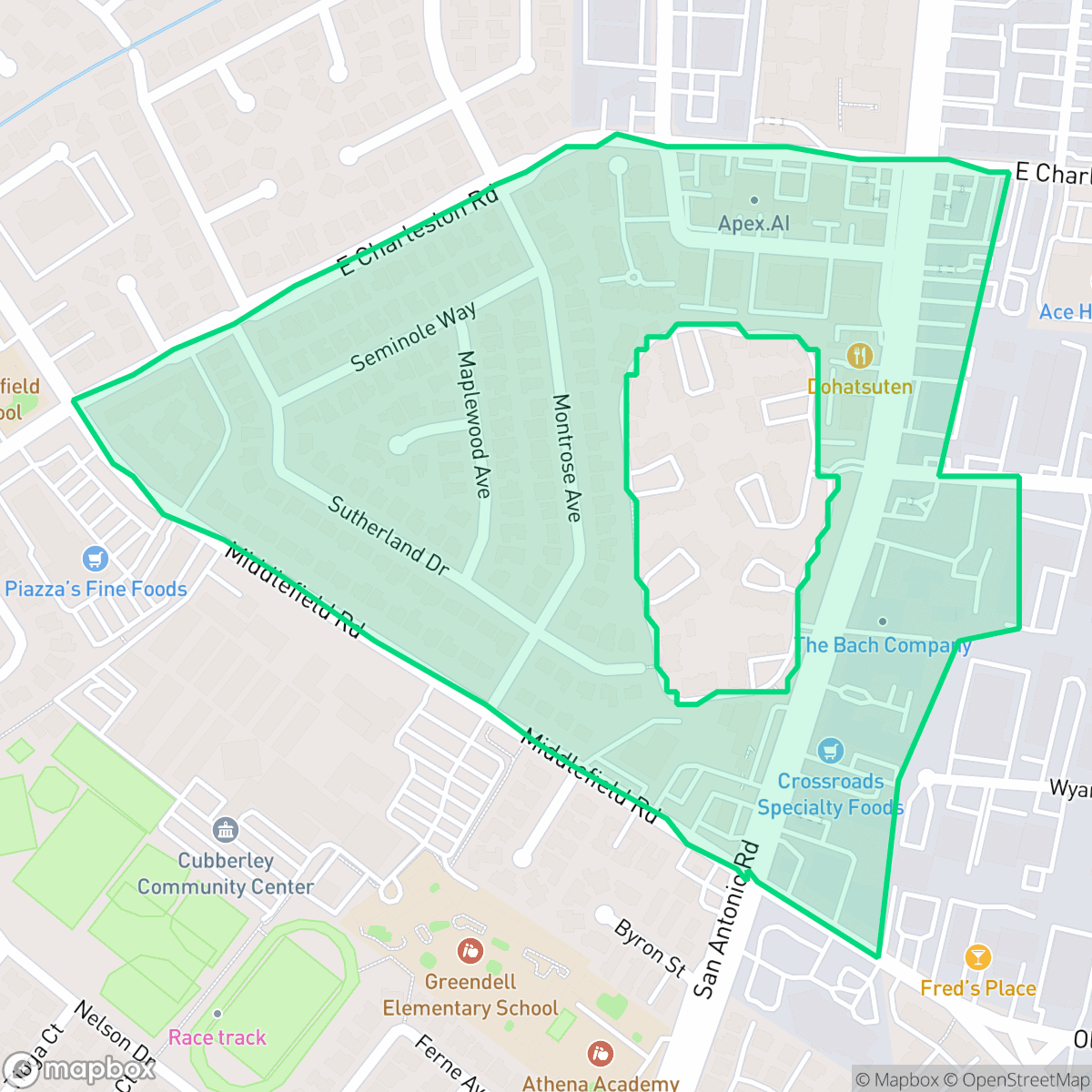
Established in 1951, the Charleston Gardens neighborhood in Palo Alto, California, features a unique architectural history. Originally planned by developers Williams and Burrows as a traditional ranch-style subdivision, the project halted when the developers went bankrupt. In 1954, mid-century modern builder Joseph Eichler purchased the remaining lots, completing the neighborhood with 78 of his signature Eichler homes. This transition created a distinctive blend of traditional ranch-style and mid-century modern residences. For a brief period, the neighborhood was absorbed into the adjacent Charleston Terrace development before reverting to its original name. Today, Charleston Gardens is bounded by East Charleston Road, Middlefield Road, Montrose Avenue, and Sutherland Drive, retaining its quiet, community-oriented character.
Charleston Gardens serves as a distinct residential pocket defined by its architectural heritage and suburban layout. The neighborhood maintains a calm environment, though it functions as a mixed-use zone where residential streets intersect with active commercial corridors. According to iHuus data, the area provides a balanced landscape with accessible green spaces, though it lacks the high-density retail and entertainment options found in more central parts of Palo Alto. Residents often frequent local establishments like the Wild Onion Bistro and Bajis Cafe, which serve as community hubs within the immediate vicinity.
Prospective residents should consider the trade-offs regarding environmental and infrastructure factors. The area experiences consistent background noise from road traffic, and the proximity to light industrial zones and an EPA Superfund site warrants consideration regarding environmental health. While the neighborhood offers access to high-performing school districts, including the Palo Alto Unified and Mountain View-Los Altos Union districts, local flood and fire safety scores indicate significant vulnerability. This location is best suited for those prioritizing a quiet, community-focused lifestyle with proximity to major regional employment hubs.
Neighborhood Scores Across 15 Qualities
Homes feature mixed spacing with some buffer between neighbors, aligning with the typical density found across Palo Alto.
Wide sidewalks and frequent crossings make navigating the area on foot easy. This level of walkability is very similar to the broader Palo Alto area, according to iHuus data.
Large homes and spacious driveways characterize the area, though the overall visual variety is lower than the Palo Alto average according to iHuus data.
Connected green spaces and wide paths provide safe areas for walking pets. This level of accessibility is roughly in line with the Palo Alto average.
Open land and scattered homes among wooded areas provide a semi-rural atmosphere that is slightly less dense than the Palo Alto average, according to iHuus data.
Calm, suburban streets define this area, which offers significantly less activity than the Palo Alto average. While local dining options exist, most essential services and businesses are not within easy walking distance.
Steady traffic hum from nearby busy streets is present; however, acoustic levels are slightly better than the Palo Alto average according to iHuus data.
Air quality in this area fluctuates between acceptable and unhealthy levels, presenting occasional concerns for sensitive groups. According to iHuus data, the air quality is slightly higher than the Palo Alto city average.
Industrial activity is significantly lower here than the Palo Alto average; however, proximity to an EPA Superfund site may present risks related to soil and groundwater contaminants. According to iHuus data, the area lacks heavy warehouses or freight corridors, though some mixed-use zones experience active commercial traffic during the day.
Health insurance access among residents is high, though slightly lower than the Palo Alto average according to iHuus data.
Voting patterns and census indicators reflect a predominantly liberal community, consistent with the broader Palo Alto area according to iHuus data.
Residents live alongside a varied mix of young professionals, families, and seniors. This demographic spread is slightly more diverse than the typical Palo Alto profile according to iHuus data.
Located within a coastal high-hazard zone, this area is subject to significant wave action and much higher flood risks than the Palo Alto average. Residents should anticipate elevated or potentially prohibitive flood insurance costs according to iHuus data.
Address-Level Insights for Charleston Gardens


iHuus Neighborhood Intelligence Insights
Get address-level neighborhood insights for Charleston Gardens
- Street-level scores — see how individual blocks compare, not just neighborhood averages
- Micro-zone boundaries — identify quiet pockets, flood boundaries, and walkable clusters before you visit
- 15 dimensions in full — walkability, noise, air quality, school quality, insurance coverage, population age profile, urban/rural index, and more
- Boundary risk alerts — know if your address sits near a block boundary where scores drop, the kind of detail no listing will ever mention
- School insights — individual school ratings and insights, not just district-level data
- Compare before you commit — side-by-side data across neighborhoods, down to block precision
No credit card required
Compare with Any Neighborhood
| Dimension | Charleston Gardens | Adobe Meadow - Meadow Park |
|---|---|---|
| 🚶 Walkabilityavg 8.94 | ||
| 🔊 Acoustic Comfortavg 3.51 | ||
| 🤫 Privacy Indexavg 5.96 | ||
| 🎨 Visual Appealavg 7.97 | ||
| 🐕 Dog Friendlinessavg 7.6 | ||
| 🗺️ Urban-Rural Indexavg 6.74 | ||
| ✨ Neighborhood Vibeavg 4.82 | ||
| 🏥 Health Insurance Coverageavg 9.05 | ||
| 🌿 Air Qualityavg 6.03 | ||
| 🏭 Industrial Proximityavg 8.67 | ||
| 🌊 Flood Safetyavg 3.52 | ||
| 🗳️ Ideological Leanavg 9.81 | ||
| 👥 Population Age Profileavg 5.03 | ||
| 🔥 Fire Safety | ||
| 🏫 School Quality |
Charleston Gardens Rankings
School Districts Serving Charleston Gardens
School Insights for Charleston Gardens
Below average outcomes; significant attendance and academic challenges.
School Insights
See what's really behind every school rating near Charleston Gardens
- Individual school ratings — each school's own score with outcome context, not just a district average
- Enrollment & class size data — student-to-teacher ratio and how it compares to the state average
- Full demographics breakdown — ethnicity and gender composition for every school in the enrollment zone
- Every school in the district — all schools within the enrollment boundary ranked by rating, not just the closest one
- Grade levels & benchmarks — elementary through high school, with below/above state-average flags
No credit card required