Country Club Heights, Pacific Grove
Updated June 22, 2026 · 228 residents
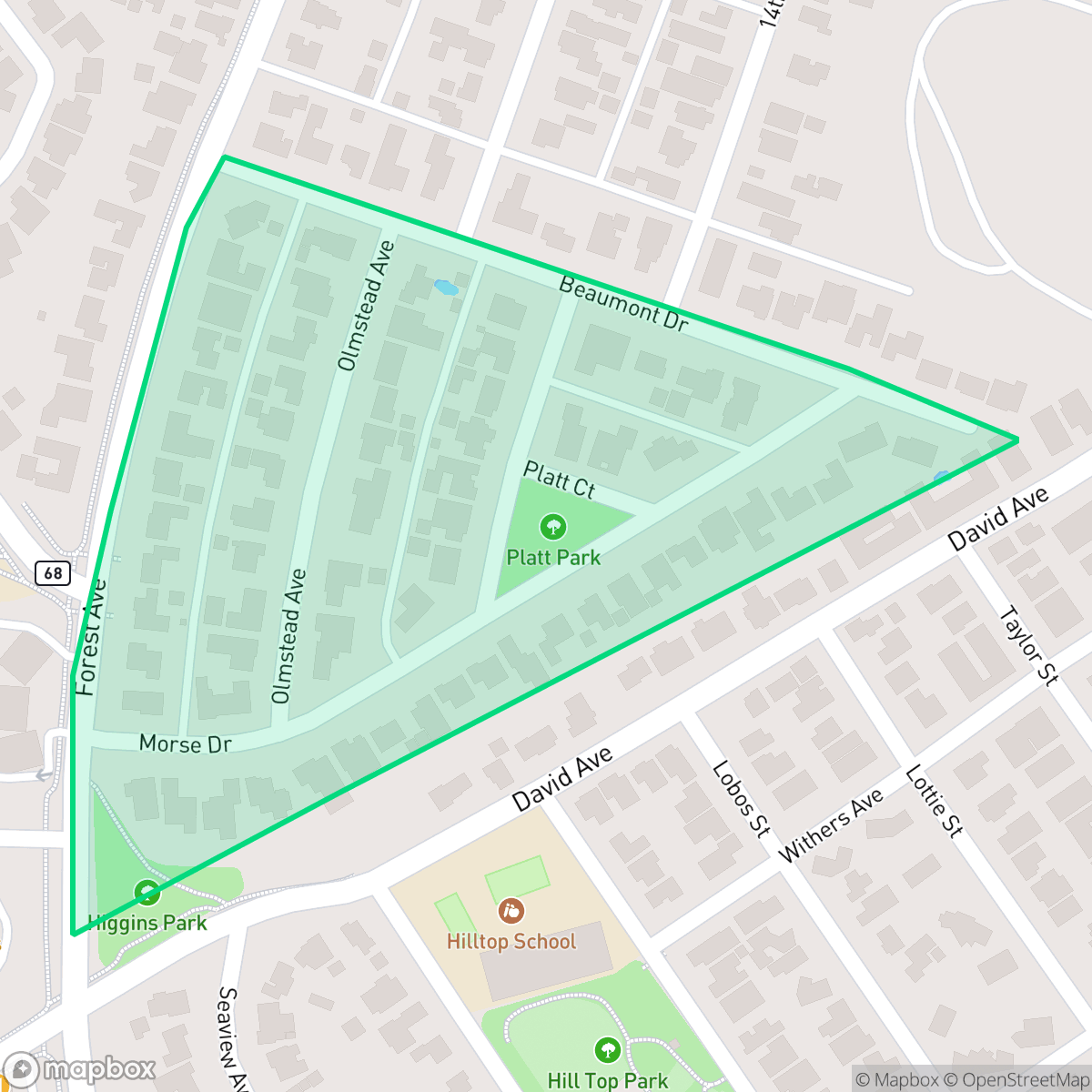
Country Club Heights is a highly walkable neighborhood defined by its grid-based layout and proximity to local recreational spaces. While residents benefit from elite school district access and a lack of industrial activity, the area features tightly packed housing with limited privacy and notable road traffic noise.
Key Highlights
About Country Club Heights
Developed in the early 1930s, the Country Club Heights subdivision in Pacific Grove was envisioned as a hub of residential growth by developer M. Spazier and the Monterey County Holding Company. To anchor this development, a unique "novel office building" was constructed in 1931 at 1001 Forest Avenue. Designed by J. W. Swope, the structure featured an early rural English style that was considered radical and unorthodox for the Monterey Peninsula at the time. Although Spazier hoped for a period of rapid expansion, the Great Depression slowed growth, and the last of the subdivision's early homes was built in 1932. Today, the neighborhood's historical connection to the adjacent Spazier tract is still visible through distinctive, matching metal light standards lining the streets and Forest Avenue.
The area offers a dense, suburban environment characterized by uniform, tract-style homes situated on small lots. Its grid-based street pattern ensures exceptional pedestrian access throughout the neighborhood, connecting residents to nearby sports fields and public parks. This layout supports an active lifestyle, particularly for dog owners who utilize the abundant local green space. According to data, the neighborhood maintains a high level of health insurance coverage and complete freedom from industrial activity, making it a stable residential choice.
Prospective residents should consider the acoustic environment, as road traffic contributes to higher noise levels compared to the city average. While the neighborhood lacks the private luxury estates found elsewhere on the Monterey Peninsula, it provides a consistent, residential setting with access to the top-rated Pacific Grove Unified School District. It is best suited for those who prioritize walkability and educational quality over quietude or expansive private property.
Neighborhood Scores Across 15 Qualities
Housing arrangements vary from closely spaced homes to detached units with moderate yard buffers. This level of residential density is roughly comparable to the average found throughout Pacific Grove.
Extensive sidewalk networks and pedestrian-priority zones make navigating the area on foot easy. This neighborhood offers superior walkability compared to the Pacific Grove average, with continuous paths connecting residential blocks to local schools and commercial hubs.
Large custom homes and manicured properties provide a polished aesthetic, though the overall visual quality sits slightly below the Pacific Grove average according to iHuus data.
Abundant forested trails and large athletic fields provide ample exercise space, though the area is slightly less dog-friendly than the Pacific Grove average. Accessible sidewalks and nearby school fields offer safe walking routes for pets.
Frequent open land and woodland areas provide a more semi-rural character than the more developed areas of Pacific Grove. According to iHuus data, the landscape features scattered homes amidst significant tree canopy and greenery.
Suburban streets offer a serene atmosphere with occasional pockets of activity near local dining and cafes. According to iHuus data, the area maintains a slightly more lively character than the typical Pacific Grove neighborhood due to nearby amenities and coastal views.
Steady traffic hum from a nearby busy street creates a level of noise that is higher than the average for Pacific Grove. Residents may notice consistent ambient sound throughout the day according to iHuus data.
No warehouses, heavy industrial facilities, or hazardous sites are present in this area. This neighborhood remains exclusively residential and institutional, consistent with the city average.
Health insurance access is exceptionally high among residents, sitting well above the Pacific Grove average according to iHuus data.
Voting patterns and census indicators reflect a predominantly liberal political leaning that is slightly more pronounced than the Pacific Grove city average, according to iHuus data.
Residents live alongside a balanced demographic of young adults, families, and seniors. This age distribution is very similar to the broader Pacific Grove area, according to iHuus data.
Flood risk in this area is slightly higher than the Pacific Grove average due to its location within a 500-year floodplain. While significant flooding is unlikely, some residual risk remains according to iHuus data.
Fire hazards are significantly higher in this area than the Pacific Grove average, necessitating enhanced property mitigation and awareness. According to iHuus data, residents should prepare for increased wildfire vulnerability compared to most other parts of the city.
Block-Level Insights for Country Club Heights

iHuus Neighborhood Intelligence Insights
Get block-level neighborhood insights for Country Club Heights
- Street-level scores — see how individual blocks compare, not just neighborhood averages
- Micro-zone boundaries — identify quiet pockets, flood boundaries, and walkable clusters before you visit
- 15 dimensions in full — walkability, noise, air quality, school quality, insurance coverage, population age profile, urban/rural index, and more
- Boundary risk alerts — know if your address sits near a block boundary where scores drop, the kind of detail no listing will ever mention
- School insights — individual school ratings and insights, not just district-level data
- Compare before you commit — side-by-side data across neighborhoods, down to block precision
No credit card required
Compare with Any Neighborhood
| Dimension | Country Club Heights | Asilomar Dunes |
|---|---|---|
| 🚶 Walkabilityavg 8.68 | ||
| 🔊 Acoustic Comfortavg 4.49 | ||
| 🤫 Privacy Indexavg 5.57 | ||
| 🎨 Visual Appealavg 7.37 | ||
| 🐕 Dog Friendlinessavg 8.15 | ||
| 🗺️ Urban-Rural Indexavg 7.2 | ||
| ✨ Neighborhood Vibeavg 5.27 | ||
| 🏥 Health Insurance Coverageavg 8.4 | ||
| 🌿 Air Quality | ||
| 🏭 Industrial Proximityavg 10 | ||
| 🌊 Flood Safetyavg 7.03 | ||
| 🗳️ Ideological Leanavg 9.43 | ||
| 👥 Population Age Profileavg 5.6 | ||
| 🔥 Fire Safetyavg 1.51 | ||
| 🏫 School Quality |
Country Club Heights Rankings
School Districts Serving Country Club Heights
Pacific Grove Unified School District is an elite, stable, and high-performing organization that functions as a premier educational anchor for the Monterey Bay area. With a portfolio of schools consistently outperforming state averages by over 30% and a high school that serves as a high-value destination for college-bound students, the district maintains strong community trust as evidenced by successful bond-funded modernization projects. Despite localized challenges regarding the high cost of living for staff and an intense academic culture, the district's 'Green' performance indicators, proactive safety protocols, and transparent fiscal management justify its status as a top-tier 'Blue Chip' district.
Schools
Monterey Peninsula Unified School District (MPUSD) is a stable but bifurcated organization, characterized by robust operational management and innovative staff retention strategies offset by a significant internal achievement gap. While the district maintains strong community trust through successful bond measures and proactive modernization, ground truth data highlights a deep disparity between its high-performing Monterey schools and its underperforming middle and alternative schools in Seaside and Marina. The district’s commitment to employee housing and a transition to phonics-based literacy indicates a forward-looking leadership, yet the 'good school vs. bad school' dynamic prevents a higher rating until academic consistency and middle school safety are more effectively addressed.
Schools
School Insights for Country Club Heights
Below average outcomes; significant attendance and academic challenges.
School Insights
See what's really behind every school rating near Country Club Heights
- Individual school ratings — each school's own score with outcome context, not just a district average
- Enrollment & class size data — student-to-teacher ratio and how it compares to the state average
- Full demographics breakdown — ethnicity and gender composition for every school in the enrollment zone
- Every school in the district — all schools within the enrollment boundary ranked by rating, not just the closest one
- Grade levels & benchmarks — elementary through high school, with below/above state-average flags
No credit card required