Sierra Linda, Oxnard
Updated · 4,458 residents
Sierra Linda is a highly walkable Oxnard neighborhood defined by its mid-century residential architecture and accessible green spaces. Residents enjoy a dense network of sidewalks and clean air, though the area experiences consistent background noise from surrounding road traffic.
Key Highlights
About Sierra Linda
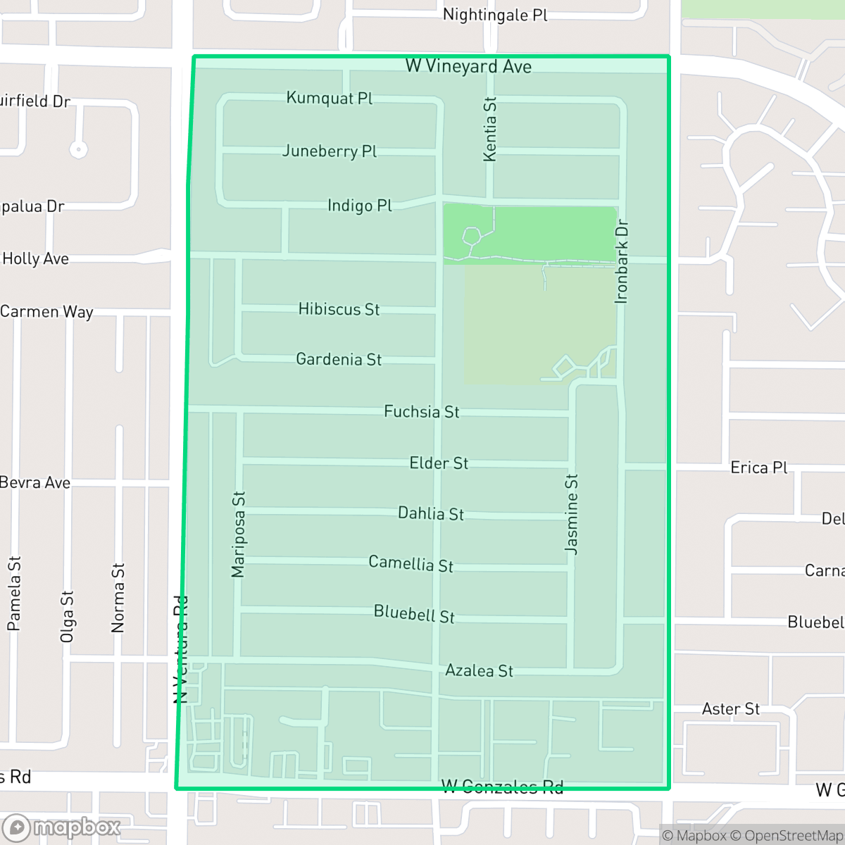
Located in Oxnard, California, the Sierra Linda neighborhood is bounded by Vineyard Avenue, Gonzales Road, H Street, and Ventura Road. Developed primarily between 1940 and 1969, the area features a mix of mid-century ranch-style and Spanish-style single-family homes alongside apartment complexes. At the heart of the community is Sierra Linda Park, a 6.2-acre public green space situated adjacent to Sierra Linda Elementary School, which opened in 1966. Historically, the school played a key role in local civil rights history; its early demographics and subsequent pairing with other schools became central to *Soria v. Oxnard School District*, a landmark 1970s federal lawsuit that forced the desegregation of Oxnard's public schools. Today, the neighborhood maintains a vibrant cultural identity, with a population predominantly of Mexican heritage.
The neighborhood features a dense suburban layout characterized by a mix of mid-century ranch and Spanish-style single-family homes alongside various apartment complexes. Its design prioritizes pedestrian connectivity, with continuous sidewalks and clear crossings throughout the area. Sierra Linda Park serves as a focal point for the community, offering extensive grass fields and verges that accommodate outdoor activities and dog walking.
While the area offers strong walkability, prospective residents should consider the acoustic environment, as road traffic contributes to an average noise level of 62 decibels. The neighborhood maintains a standard suburban density where homes are often spaced closely together, impacting overall privacy. Families should also note the local educational landscape, as the schools serving the area face significant academic performance challenges and are currently undergoing transitions to address persistent achievement gaps.
Neighborhood Scores Across 15 Qualities
Residential spacing offers a moderate level of separation between neighbors, though some areas feature closely packed houses with shared property lines. This density is slightly higher than the Oxnard average, according to iHuus data.
Continuous sidewalks on both sides of streets and clear pedestrian crossings at major intersections make navigating the area on foot easy. This level of pedestrian infrastructure is even more developed here than the average found throughout Oxnard.
Spacious homes and proximity to a golf course contribute to a visual landscape that is more polished than the Oxnard average. According to iHuus data, the area features several high-end amenities and private pools that enhance the local aesthetic.
Abundant green spaces, including large public parks and golf course perimeters, provide ample area for pet exercise. Wide sidewalk verges and connected landscapes offer more walking opportunities than the typical Oxnard neighborhood.
Residential layouts here consist of a mix of single-family homes and apartment complexes within a structured street grid. This level of development is slightly more urban than the typical Oxnard landscape, according to iHuus data.
Local activity levels are slightly above the Oxnard average, characterized by a balanced mix of residential streets and essential services. While some blocks feature accessible dining and wellness shops, many daily errands may require a short drive.
Frequent sounds from nearby transit corridors and railway lines characterize the area. According to iHuus data, acoustic levels are slightly higher than the Oxnard average.
Air quality is consistently high with minimal health concerns. This level of cleanliness is on par with the Oxnard average, according to iHuus data.
Industrial activity is notably absent within most of the neighborhood, offering a primarily residential and recreational environment. According to iHuus data, some large warehouse structures on the eastern and southeastern edges may introduce localized noise or truck traffic.
Health insurance accessibility is lower than the average for Oxnard. According to iHuus data, a minority of residents in this area are covered by health insurance plans.
Voting patterns and census indicators reflect a strong liberal leaning that is consistent with the average for Oxnard.
Residents live alongside a balanced variety of young adults, families, and seniors. This demographic spread is consistent with the broader Oxnard area, according to iHuus data.
Flood risk levels in this area are difficult to determine because FEMA has not yet completed a detailed study for this specific location. This level of uncertainty is consistent with the average found throughout Oxnard.
Address-Level Insights for Sierra Linda


iHuus Neighborhood Intelligence Insights
Get address-level neighborhood insights for Sierra Linda
- Street-level scores — see how individual blocks compare, not just neighborhood averages
- Micro-zone boundaries — identify quiet pockets, flood boundaries, and walkable clusters before you visit
- 15 dimensions in full — walkability, noise, air quality, school quality, insurance coverage, population age profile, urban/rural index, and more
- Boundary risk alerts — know if your address sits near a block boundary where scores drop, the kind of detail no listing will ever mention
- School insights — individual school ratings and insights, not just district-level data
- Compare before you commit — side-by-side data across neighborhoods, down to block precision
No credit card required
Compare with Any Neighborhood
| Dimension | Sierra Linda | Bartolo Square North |
|---|---|---|
| 🚶 Walkabilityavg 9.13 | ||
| 🔊 Acoustic Comfortavg 2.93 | ||
| 🤫 Privacy Indexavg 4.06 | ||
| 🎨 Visual Appealavg 6.08 | ||
| 🐕 Dog Friendlinessavg 6.46 | ||
| 🗺️ Urban-Rural Indexavg 6.67 | ||
| ✨ Neighborhood Vibeavg 4.7 | ||
| 🏥 Health Insurance Coverageavg 4.66 | ||
| 🌿 Air Qualityavg 9.99 | ||
| 🏭 Industrial Proximityavg 7.45 | ||
| 🌊 Flood Safetyavg 3.91 | ||
| 🗳️ Ideological Leanavg 9.3 | ||
| 👥 Population Age Profileavg 4.59 | ||
| 🔥 Fire Safetyavg 0.04 | ||
| 🏫 School Quality |
Sierra Linda Rankings
School Districts Serving Sierra Linda
School Insights for Sierra Linda
Below average outcomes; significant attendance and academic challenges.
School Insights
See what's really behind every school rating near Sierra Linda
- Individual school ratings — each school's own score with outcome context, not just a district average
- Enrollment & class size data — student-to-teacher ratio and how it compares to the state average
- Full demographics breakdown — ethnicity and gender composition for every school in the enrollment zone
- Every school in the district — all schools within the enrollment boundary ranked by rating, not just the closest one
- Grade levels & benchmarks — elementary through high school, with below/above state-average flags
No credit card required