Sobrante Park, Oakland
Updated June 22, 2026 · 3,289 residents
Sobrante Park is a self-contained East Oakland neighborhood defined by its mid-century tract housing and industrial surroundings. While the area offers a consistent sidewalk network for local travel, residents experience frequent noise from nearby rail lines and limited private space between homes.
Key Highlights
About Sobrante Park
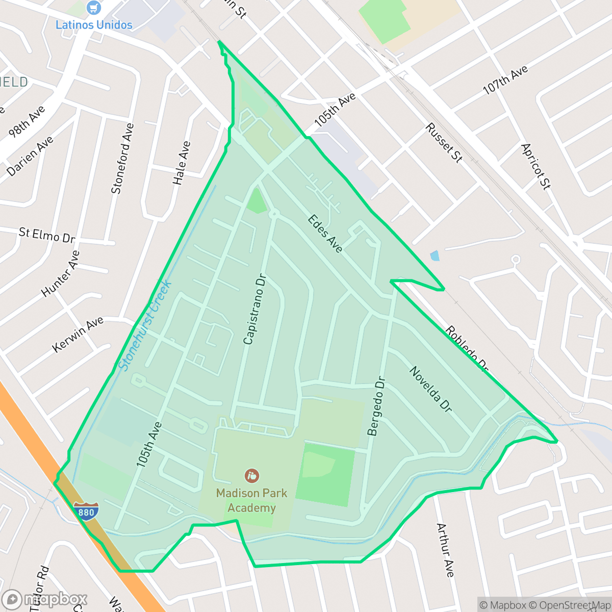
Sobrante Park in East Oakland, California, was developed in 1946 as the city's first planned community, built on former agricultural land to house returning World War II veterans. Originally restricted to white residents, the neighborhood underwent a demographic shift in the 1950s and 1960s, transitioning into a working-class Black community. Geographically isolated by two railroad tracks and San Leandro Creek, Sobrante Park has a distinct, self-contained layout. A central landmark is the half-acre Tyrone Carney Park, established in 1968 and named in honor of a local resident and Vietnam War veteran. While the neighborhood faced severe economic challenges and drug-related crime in the 1980s, giving rise to the local group "11-5", recent community-led efforts like the East Oakland Neighborhoods Initiative have worked to revitalize the area.
The neighborhood maintains a distinct, insular layout bordered by rail corridors and San Leandro Creek, which separates it from neighboring areas. The housing stock consists primarily of uniform, mid-century residential structures with high density and minimal lot setbacks. According to iHuus data, the area features a blend of residential zones and adjacent industrial sites, creating a landscape where warehouses and light manufacturing units are common neighbors to private homes. This industrial proximity contributes to the area's specific character, balancing its history as a planned community with the demands of its current urban setting. Living in the area requires navigating a setting that is notably urban in its density and proximity to industrial activity. While the street grid provides decent walkability, the presence of heavy rail traffic contributes to elevated ambient noise levels. Residents have access to local community spaces like Tyrone Carney Park, though private outdoor space remains limited due to the compact nature of the lots. The area is best suited for those seeking an established, working-class community that remains connected to the broader Oakland transit network despite its geographic isolation.
Neighborhood Scores Across 15 Qualities
Residential structures are closely packed with minimal separation between homes, reflecting a density that is slightly higher than the Oakland average. According to iHuus data, many properties feature very narrow side yards and shared walls.
Sidewalks and visible crosswalks are present throughout much of the residential grid, though major rail and freeway corridors can disrupt continuous pedestrian routes. This level of walkability is slightly lower than the Oakland average.
Standard tract housing characterizes this area, featuring uniform rooflines and modest, well-kept yards. The visual landscape is more utilitarian than the Oakland average, with many lots situated near industrial zones.
Limited public green space and narrow sidewalk verges make finding walking routes difficult. According to iHuus data, the availability of accessible parks for pets is below the Oakland average.
Residential streets and green spaces are balanced with large industrial and commercial zones. This landscape offers a suburban character that is very similar to the Oakland average, according to iHuus data.
Low levels of social activity and a landscape dominated by warehouses and transit corridors make this area less vibrant than the Oakland average. While some dining options are accessible, the neighborhood primarily serves a functional, car-oriented purpose near the railway and highway.
Frequent noise from nearby railroad tracks and major freeway traffic makes this area significantly louder than the Oakland average. According to iHuus data, persistent sounds from transit corridors are a primary feature of the local acoustic environment.
Air quality in this area fluctuates between acceptable and unhealthy levels, which is notably lower than the Oakland average. Sensitive individuals should monitor local conditions during periods of occasional concern.
Large warehouses and logistics hubs border residential areas, creating more truck traffic and noise than is typical for Oakland. According to iHuus data, these industrial zones are concentrated near the eastern edges of the neighborhood.
Health insurance coverage among residents is nearly in line with the Oakland average. Most community members have access to medical coverage, according to iHuus data.
Voting patterns and census indicators show a deeply liberal political leaning that is consistent with the rest of Oakland. This ideological profile is reflected in the local community landscape according to iHuus data.
Residents live alongside a balanced mix of young adults, families, and seniors. This age distribution is slightly lower than the Oakland average, according to iHuus data.
Properties in this area are situated within a designated floodplain, meaning residents should anticipate a higher risk of flooding and the likely requirement for flood insurance. According to iHuus data, this level of risk is consistent with the average seen across Oakland.
Block-Level Insights for Sobrante Park

iHuus Neighborhood Intelligence Insights
Get block-level neighborhood insights for Sobrante Park
- Street-level scores — see how individual blocks compare, not just neighborhood averages
- Micro-zone boundaries — identify quiet pockets, flood boundaries, and walkable clusters before you visit
- 15 dimensions in full — walkability, noise, air quality, school quality, insurance coverage, population age profile, urban/rural index, and more
- Boundary risk alerts — know if your address sits near a block boundary where scores drop, the kind of detail no listing will ever mention
- School insights — individual school ratings and insights, not just district-level data
- Compare before you commit — side-by-side data across neighborhoods, down to block precision
No credit card required
Compare with Any Neighborhood
| Dimension | Sobrante Park | Acorn |
|---|---|---|
| 🚶 Walkabilityavg 8.99 | ||
| 🔊 Acoustic Comfortavg 3.24 | ||
| 🤫 Privacy Indexavg 3.74 | ||
| 🎨 Visual Appealavg 6.28 | ||
| 🐕 Dog Friendlinessavg 5.74 | ||
| 🗺️ Urban-Rural Indexavg 6.02 | ||
| ✨ Neighborhood Vibeavg 5.22 | ||
| 🏥 Health Insurance Coverageavg 7.4 | ||
| 🌿 Air Qualityavg 8.06 | ||
| 🏭 Industrial Proximityavg 8.37 | ||
| 🌊 Flood Safetyavg 2.61 | ||
| 🗳️ Ideological Leanavg 9.95 | ||
| 👥 Population Age Profileavg 4.92 | ||
| 🔥 Fire Safetyavg 0.17 | ||
| 🏫 School Quality |
Sobrante Park Rankings
School Districts Serving Sobrante Park
San Leandro Unified is an operationally stable but academically bifurcated district characterized by strong community financial support and a diverse, inclusive environment. While it boasts a high graduation rate and proactive facility modernizations through local bonds, it struggles with severe proficiency gaps in mathematics and low-performing middle and high school cohorts. The district is currently in a transitional phase, attempting to boost college readiness by aligning graduation requirements with A-G standards, but it remains hampered by a wide variance in school quality across its elementary-to-secondary pipeline.
Schools
Oakland Unified School District is currently in a distressed state, characterized by a massive $100 million budget deficit, high-stakes labor disputes, and a facilities maintenance backlog exceeding $3.5 billion. While the district maintains several high-achieving 'Blue Chip' elementary schools (e.g., Lincoln, Chabot), these are outliers in a portfolio where nearly half of the schools are performing at the lowest state levels. The combination of declining enrollment, 400 recent staff layoffs, and the constant threat of state receivership indicates an organization struggling with long-term stability and equitable academic delivery.
Schools
School Insights for Sobrante Park
Below average outcomes; significant attendance and academic challenges.
School Insights
See what's really behind every school rating near Sobrante Park
- Individual school ratings — each school's own score with outcome context, not just a district average
- Enrollment & class size data — student-to-teacher ratio and how it compares to the state average
- Full demographics breakdown — ethnicity and gender composition for every school in the enrollment zone
- Every school in the district — all schools within the enrollment boundary ranked by rating, not just the closest one
- Grade levels & benchmarks — elementary through high school, with below/above state-average flags
No credit card required