West Adams, Los Angeles
Updated · 28,272 residents
West Adams is a historic Los Angeles neighborhood defined by its dense collection of preserved architectural styles and a grid-based street layout. While the area offers high walkability and access to diverse local dining, residents often experience significant traffic noise and limited public green space. According to iHuus data, the neighborhood maintains a dense urban character with closely spaced housing and minimal private lot amenities.
Key Highlights
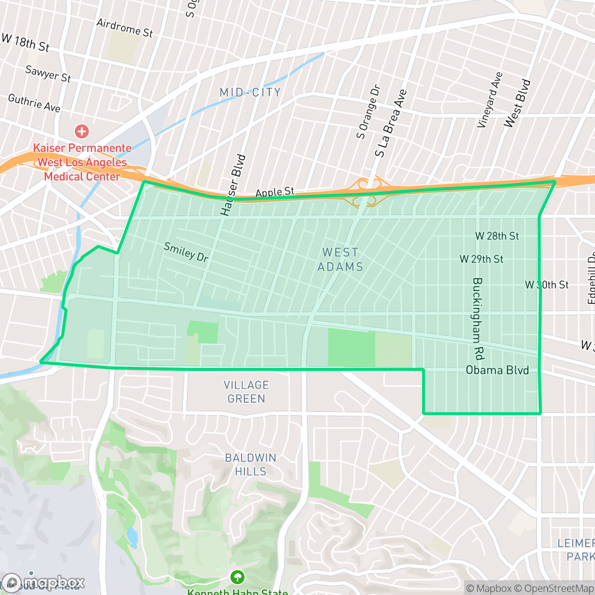
About West Adams
Developed between 1880 and 1925 by figures like Henry E. Huntington, West Adams is one of Los Angeles's oldest and most architecturally diverse neighborhoods. It features an extraordinary concentration of historic homes west of the Mississippi, showcasing Queen Anne, Craftsman, and Beaux-Arts styles. Originally an exclusive enclave for wealthy white elites and silent film stars, the area underwent a major demographic shift in the 1940s. A rising Black upper class moved into the "Sugar Hill" section, defying racially restrictive covenants. In 1945, resident and Oscar-winning actress Hattie McDaniel led a landmark legal victory (Tolhurst v. Venerable) that struck down these discriminatory housing barriers. Although the construction of the Santa Monica Freeway in the 1960s physically divided the community, West Adams remains a vital cultural landmark celebrated for its architectural preservation and civil rights legacy.
The neighborhood functions as a dense, low-rise urban grid characterized by a mix of single-family homes and multi-unit complexes. Its layout provides a consistent sidewalk network that supports high walkability, though the presence of major thoroughfares and the Santa Monica Freeway creates physical barriers and contributes to a high-traffic environment. While the area lacks the expansive public parks found in other parts of the city, it features a variety of unique, independent dining establishments and functional community spaces that cater to a diverse local population. The architectural landscape remains a standout feature, with many structures reflecting the area's long history as a residential hub for the city's early elite.
Prospective residents should consider the trade-offs associated with the area's high density and proximity to major infrastructure. Acoustic comfort is a primary concern, as population-weighted noise levels are elevated due to constant road traffic. Additionally, the neighborhood has limited public green space and dog-friendly amenities, making it better suited for those who prioritize a central location and historic character over suburban quiet or sprawling private yards. Educational options are varied, with residents served by both the Los Angeles Unified School District and the Culver City Unified School District, each offering different academic environments and performance outcomes.
Neighborhood Scores Across 15 Qualities
Housing structures and multi-unit buildings are positioned in close quarters with minimal separation between properties. This level of density is slightly higher than the average for Los Angeles, which can result in limited privacy between adjacent homes.
A consistent grid of sidewalks and marked crosswalks facilitates pedestrian movement through residential blocks, though major highways and high-traffic arterials create notable barriers. While the network is highly accessible, the proximity to heavy transit corridors makes the area slightly less walkable than the Los Angeles average.
Standard tract housing and mid-density apartments dominate the landscape, featuring uniform rooflines and small yards. This level of visual interest is slightly below the Los Angeles average, according to iHuus data.
Public green space and wide grass verges for walking are sparse throughout much of the area. According to iHuus data, dog-friendly amenities in this neighborhood are below the city average, with most greenery restricted to private backyards or specific park buffers.
Streets and green spaces exist in roughly equal measure throughout the area. This density of infrastructure and vegetation aligns with the typical urban-suburban balance found across Los Angeles.
Suburban streets and light industrial pockets create a calm atmosphere, but most dining and services require a vehicle due to limited walkability. This steady, low-key rhythm is more subdued than the typical Los Angeles urban experience, according to iHuus data.
Frequent acoustic disturbance from nearby freeway traffic and railroad tracks characterizes this area. According to iHuus data, noise levels in West Adams are notably higher than the city average.
Air quality remains consistently high with rare instances of elevated readings. This level of cleanliness is roughly in line with the overall average for Los Angeles.
Largely residential with some light commercial activity, though proximity to major freeways and certain warehouse corridors introduces more noise and traffic than the city average. According to iHuus data, heavy industrial hazards are absent, but some areas near rail corridors and large warehouses may experience increased truck activity.
Health insurance access in West Adams is consistent with the city average. According to iHuus data, residents face a moderate level of coverage availability similar to other parts of Los Angeles.
Voting patterns and census indicators show a very strong liberal leaning, which is even more pronounced than the typical pattern seen across Los Angeles.
Residents live alongside a balanced mix of young professionals, families, and older adults. This demographic distribution is nearly identical to the broader Los Angeles area, according to iHuus data.
Property is situated within a designated floodplain, meaning residents may face a higher risk of flooding than the average Los Angeles area. According to iHuus data, flood insurance is typically required for homes in this part of West Adams.
Fire safety infrastructure and response readiness in this area are slightly below the Los Angeles city average, according to iHuus data.
Address-Level Insights for West Adams


iHuus Neighborhood Intelligence Insights
Get address-level neighborhood insights for West Adams
- Street-level scores — see how individual blocks compare, not just neighborhood averages
- Micro-zone boundaries — identify quiet pockets, flood boundaries, and walkable clusters before you visit
- 15 dimensions in full — walkability, noise, air quality, school quality, insurance coverage, population age profile, urban/rural index, and more
- Boundary risk alerts — know if your address sits near a block boundary where scores drop, the kind of detail no listing will ever mention
- School insights — individual school ratings and insights, not just district-level data
- Compare before you commit — side-by-side data across neighborhoods, down to block precision
No credit card required
Compare with Any Neighborhood
| Dimension | West Adams | Adams-Normandie |
|---|---|---|
| 🚶 Walkabilityavg 8.9 | ||
| 🔊 Acoustic Comfortavg 2.91 | ||
| 🤫 Privacy Indexavg 4.14 | ||
| 🎨 Visual Appealavg 6.58 | ||
| 🐕 Dog Friendlinessavg 5.04 | ||
| 🗺️ Urban-Rural Indexavg 5.96 | ||
| ✨ Neighborhood Vibeavg 5.07 | ||
| 🏥 Health Insurance Coverageavg 6.2 | ||
| 🌿 Air Qualityavg 8.12 | ||
| 🏭 Industrial Proximityavg 8.46 | ||
| 🌊 Flood Safetyavg 2.66 | ||
| 🗳️ Ideological Leanavg 9.56 | ||
| 👥 Population Age Profileavg 4.85 | ||
| 🔥 Fire Safetyavg 0.18 | ||
| 🏫 School Quality |
West Adams Rankings
School Districts Serving West Adams
School Insights for West Adams
Below average outcomes; significant attendance and academic challenges.
School Insights
See what's really behind every school rating near West Adams
- Individual school ratings — each school's own score with outcome context, not just a district average
- Enrollment & class size data — student-to-teacher ratio and how it compares to the state average
- Full demographics breakdown — ethnicity and gender composition for every school in the enrollment zone
- Every school in the district — all schools within the enrollment boundary ranked by rating, not just the closest one
- Grade levels & benchmarks — elementary through high school, with below/above state-average flags
No credit card required