Van Nuys, Los Angeles
Updated · 103,442 residents
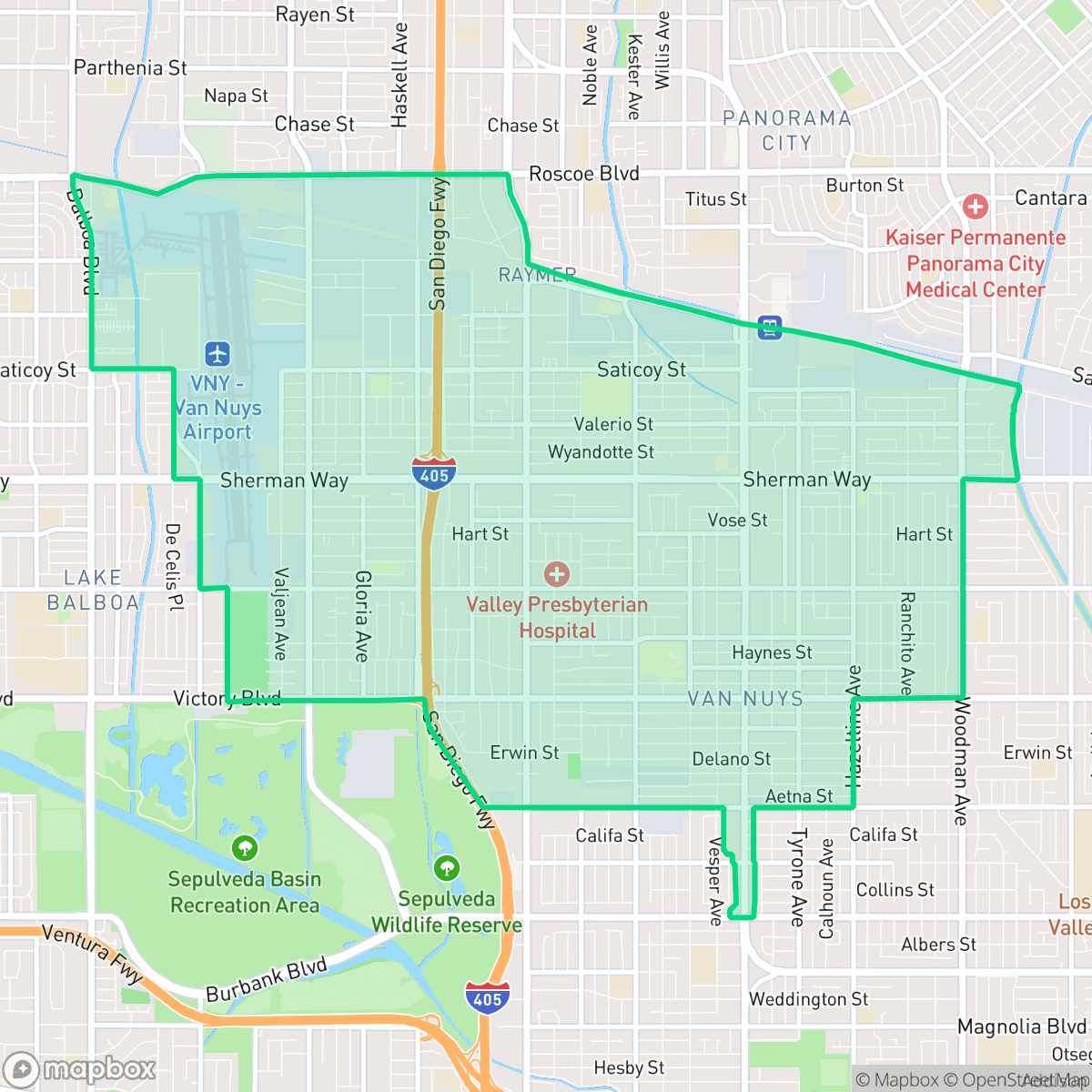
Van Nuys serves as the central hub of the San Fernando Valley, defined by its dense urban grid, significant industrial presence, and diverse residential landscape. While the area offers high walkability and convenient access to local services, residents often navigate a high-density environment with limited privacy and notable noise from road traffic.
Key Highlights
About Van Nuys
Founded on February 22, 1911, and named after rancher Isaac Newton Van Nuys, the neighborhood of Van Nuys was established as a planned farming town by the Los Angeles Suburban Homes Company. It was annexed by Los Angeles in 1915 following the completion of the Los Angeles Aqueduct, which secured its water supply. The neighborhood serves as the San Fernando Valley's municipal hub, anchored by the iconic 1932 Art Deco Valley Municipal Building (Van Nuys City Hall). Following World War II, Van Nuys transformed from a sleepy agricultural community into an industrial and commercial center, hosting a major General Motors assembly plant and the historic Van Nuys Airport. During the 1960s and 1970s, Van Nuys Boulevard gained national fame as the epicenter of Southern California's teenage cruising and car culture.
This neighborhood functions as a primary commercial and municipal center, characterized by a dense mix of single-family homes, multi-unit apartment complexes, and large-scale industrial warehouses. The layout features a consistent grid of streets and sidewalks, making it physically accessible for pedestrians, though the proximity to major transit corridors and industrial zones contributes to higher noise levels. According to iHuus data, the area is marked by a dense suburban and urban mix that prioritizes logistical and residential utility over secluded green space.
Living in this area involves certain trade-offs, particularly regarding privacy and acoustic comfort, as many homes are situated in close proximity to one another and major transportation arteries. It is best suited for individuals who prioritize central access to the San Fernando Valley and reliable transit connectivity over quiet, low-density living. While the neighborhood lacks expansive public parks, its practical layout and diverse local dining options provide a functional environment for those seeking a central urban base.
Neighborhood Scores Across 15 Qualities
Building proximity varies throughout the area, with many residential lots featuring closely spaced homes or shared walls in apartment complexes. This level of density is slightly higher than the average for Los Angeles, offering a mix of suburban spacing and compact urban housing.
A consistent grid of sidewalks and marked crosswalks makes much of the area accessible to pedestrians, though large freeways and industrial zones can act as significant barriers. While highly walkable, the ease of movement is slightly lower than the average for Los Angeles.
Residential pockets feature well-maintained homes with private pools and manicured lawns, offering a visual quality that is slightly above the city average. The landscape shifts between affluent suburban clusters and denser, more uniform apartment blocks and industrial sectors.
Walking routes for pets are often restricted to narrow sidewalk verges and private backyards, as large public parks are sparse throughout much of the area. According to iHuus data, the availability of accessible green space for dogs is slightly below the city average.
A diverse landscape of single-family homes and apartment complexes sits alongside large-scale industrial warehouses and airport infrastructure. This mix of residential and utility-heavy land use is slightly more open than the typical Los Angeles urban profile, according to iHuus data.
The area features a subdued atmosphere characterized by industrial pockets and suburban blocks. While diverse dining options exist, many residents will find the neighborhood slightly less active than the Los Angeles average due to a heavy reliance on vehicles for errands.
Frequent sounds from nearby freeways, railroad tracks, and flight paths create a loud environment. This level of acoustic disturbance is consistent with the broader Los Angeles average.
Air quality remains consistently good with only rare instances of elevated readings. This level of air purity is roughly in line with the average found throughout Los Angeles.
While much of the area remains residential, residents may encounter noise and heavy truck traffic near the airport runways and large logistics warehouses located on the neighborhood's edges. This level of industrial proximity is slightly higher than the city average, as large-scale warehouses and rail corridors are concentrated in specific quadrants.
Health insurance access among residents is below the Los Angeles average, according to iHuus data. This indicates a higher proportion of uninsured individuals compared to much of the city.
Voting patterns and census indicators reflect a strong liberal leaning that is consistent with the broader Los Angeles area, according to iHuus data.
Residents live alongside a balanced variety of young adults, families, and seniors. This demographic distribution is roughly in line with the broader Los Angeles area, according to iHuus data.
Significant flood risk exists due to the area's location within a 100-year floodplain; according to iHuus data, this risk is notably higher than the Los Angeles city average.
Address-Level Insights for Van Nuys


iHuus Neighborhood Intelligence Insights
Get address-level neighborhood insights for Van Nuys
- Street-level scores — see how individual blocks compare, not just neighborhood averages
- Micro-zone boundaries — identify quiet pockets, flood boundaries, and walkable clusters before you visit
- 15 dimensions in full — walkability, noise, air quality, school quality, insurance coverage, population age profile, urban/rural index, and more
- Boundary risk alerts — know if your address sits near a block boundary where scores drop, the kind of detail no listing will ever mention
- School insights — individual school ratings and insights, not just district-level data
- Compare before you commit — side-by-side data across neighborhoods, down to block precision
No credit card required
Compare with Any Neighborhood
| Dimension | Van Nuys | Adams-Normandie |
|---|---|---|
| 🚶 Walkabilityavg 8.9 | ||
| 🔊 Acoustic Comfortavg 2.91 | ||
| 🤫 Privacy Indexavg 4.14 | ||
| 🎨 Visual Appealavg 6.58 | ||
| 🐕 Dog Friendlinessavg 5.04 | ||
| 🗺️ Urban-Rural Indexavg 5.96 | ||
| ✨ Neighborhood Vibeavg 5.07 | ||
| 🏥 Health Insurance Coverageavg 6.2 | ||
| 🌿 Air Qualityavg 8.12 | ||
| 🏭 Industrial Proximityavg 8.46 | ||
| 🌊 Flood Safetyavg 2.66 | ||
| 🗳️ Ideological Leanavg 9.56 | ||
| 👥 Population Age Profileavg 4.85 | ||
| 🔥 Fire Safetyavg 0.18 | ||
| 🏫 School Quality |
Van Nuys Rankings
School Districts Serving Van Nuys
School Insights for Van Nuys
Below average outcomes; significant attendance and academic challenges.
School Insights
See what's really behind every school rating near Van Nuys
- Individual school ratings — each school's own score with outcome context, not just a district average
- Enrollment & class size data — student-to-teacher ratio and how it compares to the state average
- Full demographics breakdown — ethnicity and gender composition for every school in the enrollment zone
- Every school in the district — all schools within the enrollment boundary ranked by rating, not just the closest one
- Grade levels & benchmarks — elementary through high school, with below/above state-average flags
No credit card required