South Los Angeles, Los Angeles
Updated · 203,552 residents
South Los Angeles is a dense, highly walkable urban area characterized by a consistent grid of residential streets and proximity to major city landmarks. While the neighborhood offers excellent pedestrian access to local services, residents experience high noise levels from road traffic and limited privacy due to the close proximity of housing structures.
Key Highlights
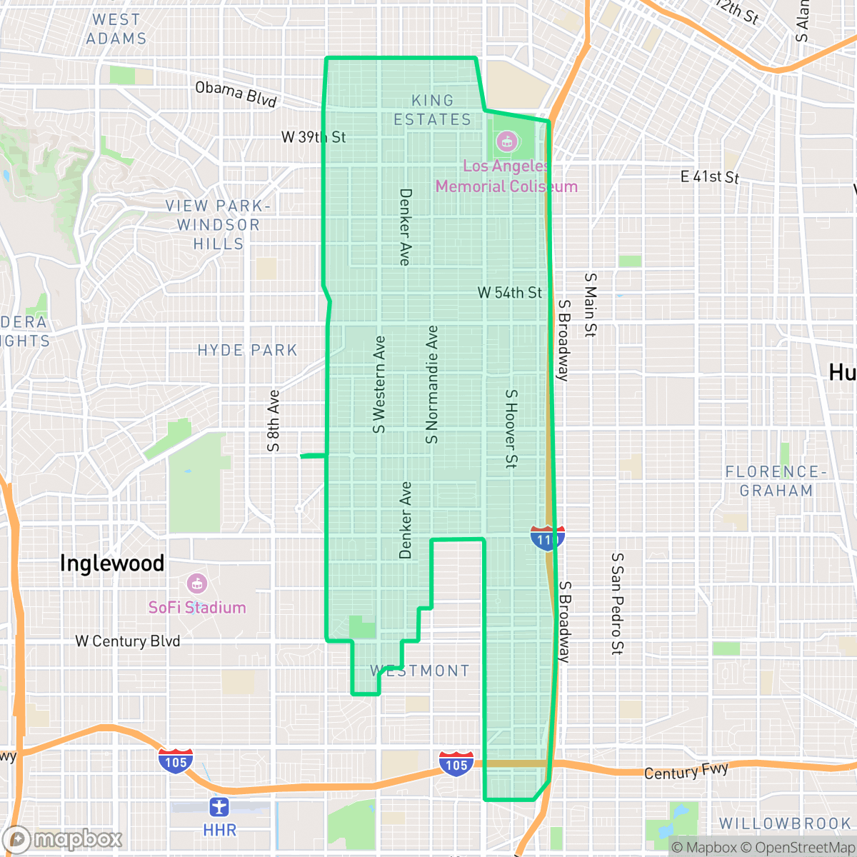
About South Los Angeles
South Los Angeles, officially renamed from South Central in 2003, developed in the late 19th and early 20th centuries as African Americans settled around the landholdings of pioneer Biddy Mason. By the 1920s, Central Avenue emerged as the cultural heartbeat of Black Los Angeles and a legendary West Coast jazz hub, anchored by the historic Dunbar Hotel (1928). The region boasts rich architectural landmarks, including the Romanesque Revival Second Baptist Church, designed by renowned architect Paul R. Williams in 1925, and Simon Rodia’s iconic Watts Towers, constructed between 1921 and 1954. Neighborhoods like Leimert Park feature Spanish-style Art Deco gems like the Vision Theatre. Following demographic shifts in the late 20th century, South Los Angeles evolved into a multicultural hub with a prominent Latino population, while continuing to preserve its deep-seated musical, artistic, and civil rights legacy.
The neighborhood functions as a dense, low-rise urban grid that prioritizes pedestrian connectivity through a comprehensive sidewalk network. It features a mix of single-family homes and multi-unit complexes, with a landscape dominated by standard tract housing and limited private outdoor space. According to iHuus data, residents benefit from high accessibility to basic services and public transit corridors, making it a functional choice for those who rely on walking or public transportation for daily needs. The area maintains a steady rhythm of urban life, supported by a variety of local dining and service options integrated into the residential fabric. Living here involves navigating a high-density environment where houses are often spaced closely together, resulting in limited residential privacy. The area experiences significant acoustic impact from road traffic, and public green space is relatively scarce, with most vegetation contained within private yards. It is best suited for individuals who prioritize urban convenience and connectivity over quiet, expansive living environments.
Neighborhood Scores Across 15 Qualities
Residential structures are tightly packed with minimal separation between neighbors. This high-density layout results in significantly less privacy than the Los Angeles average due to narrow side yards and closely spaced homes.
Continuous sidewalks on both sides of every street and frequent crosswalks ensure excellent pedestrian connectivity. This accessibility is even higher than the Los Angeles average, according to iHuus data.
Standard tract housing and small lots dominate the landscape, featuring uniform rooflines and minimal private yard space. This area lacks the large estates and luxury amenities found more frequently elsewhere in Los Angeles.
Public park access is sparse and most greenery is confined to private, fenced backyards. Street-level walking options for dogs are limited due to narrow sidewalks and a lack of accessible green verges compared to the city average.
High building coverage and significant grey infrastructure define the area, leaving little open natural space or tree canopy. This landscape is slightly more urbanized than the Los Angeles average, characterized by tightly packed single-family homes and multi-unit complexes.
A blend of quiet suburban streets and lively urban pockets provides a consistent rhythm of life. Residents can find a varied selection of local dining and community hubs, though many amenities require a short drive as walkable business density is often limited.
Frequent sounds from nearby freeways and railroad corridors create a disruptive acoustic environment. According to iHuus data, noise levels in this area are more significant than the city average.
Air quality remains generally good with infrequent periods of elevated readings. According to iHuus data, the quality is slightly lower than the city average.
Industrial presence is minimal across most of the area, offering a landscape largely composed of residential and light commercial zones. This provides a cleaner environment than the city average, as heavy warehouses and industrial hazards are rarely detected.
Access to health insurance is lower than the Los Angeles average. According to iHuus data, a minority of the local population maintains active coverage.
Voting patterns and census indicators reflect a deeply liberal political leaning, which is even more pronounced than the average seen across Los Angeles.
Residents live alongside a balanced mix of young adults, families, and seniors. This demographic spread is slightly lower than the average seen across Los Angeles, according to iHuus data.
Flood risk in this area is significantly higher than the Los Angeles average. Residents should prepare for elevated or potentially prohibitive flood insurance costs according to iHuus data.
Address-Level Insights for South Los Angeles


iHuus Neighborhood Intelligence Insights
Get address-level neighborhood insights for South Los Angeles
- Street-level scores — see how individual blocks compare, not just neighborhood averages
- Micro-zone boundaries — identify quiet pockets, flood boundaries, and walkable clusters before you visit
- 15 dimensions in full — walkability, noise, air quality, school quality, insurance coverage, population age profile, urban/rural index, and more
- Boundary risk alerts — know if your address sits near a block boundary where scores drop, the kind of detail no listing will ever mention
- School insights — individual school ratings and insights, not just district-level data
- Compare before you commit — side-by-side data across neighborhoods, down to block precision
No credit card required
Compare with Any Neighborhood
| Dimension | South Los Angeles | Adams-Normandie |
|---|---|---|
| 🚶 Walkabilityavg 8.9 | ||
| 🔊 Acoustic Comfortavg 2.91 | ||
| 🤫 Privacy Indexavg 4.14 | ||
| 🎨 Visual Appealavg 6.58 | ||
| 🐕 Dog Friendlinessavg 5.04 | ||
| 🗺️ Urban-Rural Indexavg 5.96 | ||
| ✨ Neighborhood Vibeavg 5.07 | ||
| 🏥 Health Insurance Coverageavg 6.2 | ||
| 🌿 Air Qualityavg 8.12 | ||
| 🏭 Industrial Proximityavg 8.46 | ||
| 🌊 Flood Safetyavg 2.66 | ||
| 🗳️ Ideological Leanavg 9.56 | ||
| 👥 Population Age Profileavg 4.85 | ||
| 🔥 Fire Safetyavg 0.18 | ||
| 🏫 School Quality |
South Los Angeles Rankings
School Districts Serving South Los Angeles
School Insights for South Los Angeles
Below average outcomes; significant attendance and academic challenges.
School Insights
See what's really behind every school rating near South Los Angeles
- Individual school ratings — each school's own score with outcome context, not just a district average
- Enrollment & class size data — student-to-teacher ratio and how it compares to the state average
- Full demographics breakdown — ethnicity and gender composition for every school in the enrollment zone
- Every school in the district — all schools within the enrollment boundary ranked by rating, not just the closest one
- Grade levels & benchmarks — elementary through high school, with below/above state-average flags
No credit card required