Mar Vista, Los Angeles
Updated · 37,439 residents
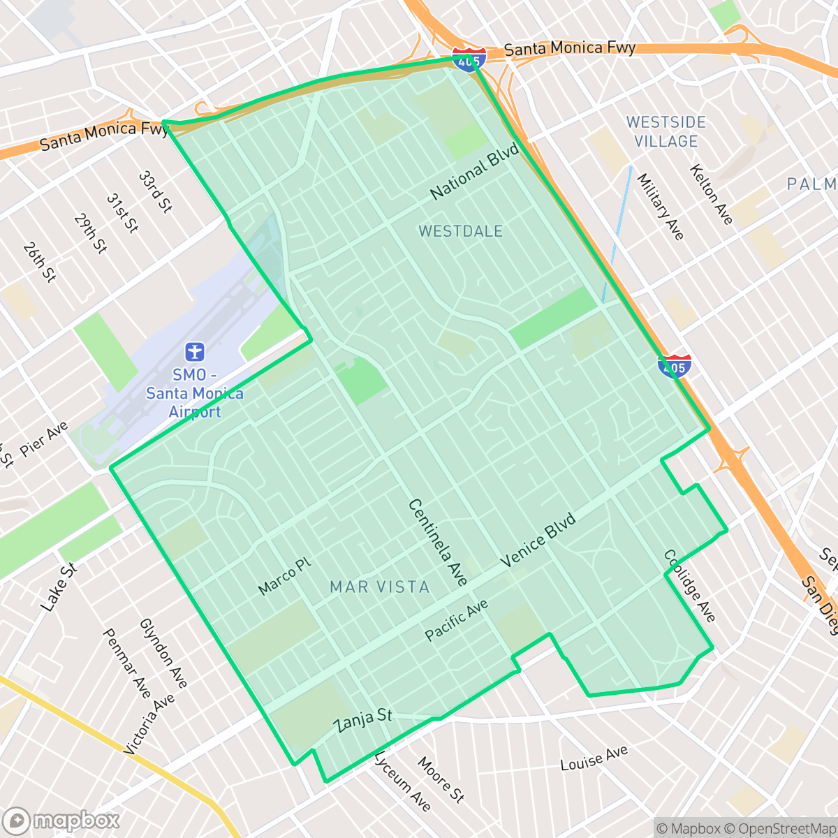
Mar Vista is a quiet, highly walkable residential community known for its mid-century modern architecture and a diverse, multi-generational population. While the area offers a peaceful atmosphere with clean air and minimal industrial presence, residents should anticipate notable traffic noise from nearby freeways and limited access to public park space.
Key Highlights
About Mar Vista
Originally known as Ocean Park Heights, the neighborhood was renamed Mar Vista—meaning 'sea view'—in 1924 and annexed by Los Angeles in 1927. Historically defined by its role in the 'Lima Bean Belt,' the area transitioned from agricultural land to a residential community, spurred by the Venice Short Line trolley. The neighborhood is architecturally significant for its mid-century modern heritage, most notably the 1948 Mar Vista Tract designed by Gregory Ain, the city’s first historic district consisting solely of post-WWII modern homes. Other landmarks include Mar Vista Hill, which has served various roles from farmland and military site to the North Venice Little League fields, and the historic Mar Vista Branch Library. Today, the area is recognized for its blend of early 20th-century development and mid-century suburban expansion, maintaining a distinct identity within the Westside.
The area functions as a dense suburban enclave that balances a strong sense of community with a highly walkable street grid. Residents benefit from a clean environment free of heavy industry and high rates of health insurance coverage. The neighborhood maintains a consistent, low-key rhythm that appeals to those seeking a stable home life within the broader Westside landscape, characterized by a mix of affluent residential pockets and standard high-density housing.
Prospective residents should consider the trade-offs of living in a location defined by its proximity to major transit corridors. While the grid layout supports easy pedestrian navigation, the neighborhood experiences significant traffic noise and faces higher flood risks than the city average. According to iHuus data, it is a well-suited choice for those who prioritize community stability and architectural character over immediate access to large public parks. Families have access to a range of school districts, including the Culver City and Santa Monica-Malibu systems, though local options vary in academic performance and organizational stability.
Neighborhood Scores Across 15 Qualities
Residential spacing provides a moderate level of buffer between neighbors, which is slightly higher than the Los Angeles average. Some areas feature closely packed houses and shared walls that offer less separation between structures.
Continuous sidewalks and clearly marked crosswalks exist throughout most residential and commercial streets. This network is more comprehensive than the typical Los Angeles neighborhood, though the nearby freeway interchange creates a notable barrier for pedestrians.
Residential aesthetics range from affluent pockets featuring large homes and private pools to more standard high-density housing. This level of visual variety is roughly in line with the city average for Los Angeles.
Available walking areas for pets are primarily restricted to sidewalk verges and school athletic fields. Public park access and continuous grassy areas are slightly below the Los Angeles average, according to iHuus data.
A blend of single-family homes and low-rise apartment complexes creates a dense suburban fabric. This landscape features slightly more open space than the typical Los Angeles urban environment.
Suburban streets and light industrial zones create a steady but low-key atmosphere that is slightly more subdued than the Los Angeles average. While various cafes and eateries provide a consistent rhythm of life, many commercial services require a car for easy access.
Frequent noise from nearby freeway corridors and transit paths is common here. According to iHuus data, acoustic comfort levels are lower than the Los Angeles average.
Air quality remains consistently high with infrequent periods of poor visibility or pollution. According to iHuus data, these levels are roughly in line with the average found across Los Angeles.
Heavy industrial facilities and hazardous warehouses are absent from the neighborhood, making it cleaner and more residential than most of Los Angeles. Residents may only encounter light commercial activity or loading docks on the periphery, though noise from the adjacent freeway and airport remains a factor.
Health insurance accessibility is notably higher here than the Los Angeles average, according to iHuus data. Most residents in the area are covered by a health insurance plan.
Voting patterns and census indicators show a heavily liberal leaning that is even more pronounced than the Los Angeles city average, according to iHuus data.
Residents live alongside a balanced spread of young adults, families, and older individuals. This demographic distribution is slightly more diverse than the average found across Los Angeles.
Flood risk in this area is significantly higher than the Los Angeles average, though specific levels remain undetermined due to incomplete federal studies. According to iHuus data, the neighborhood lacks a detailed FEMA flood study, necessitating caution during extreme weather events.
Address-Level Insights for Mar Vista


iHuus Neighborhood Intelligence Insights
Get address-level neighborhood insights for Mar Vista
- Street-level scores — see how individual blocks compare, not just neighborhood averages
- Micro-zone boundaries — identify quiet pockets, flood boundaries, and walkable clusters before you visit
- 15 dimensions in full — walkability, noise, air quality, school quality, insurance coverage, population age profile, urban/rural index, and more
- Boundary risk alerts — know if your address sits near a block boundary where scores drop, the kind of detail no listing will ever mention
- School insights — individual school ratings and insights, not just district-level data
- Compare before you commit — side-by-side data across neighborhoods, down to block precision
No credit card required
Compare with Any Neighborhood
| Dimension | Mar Vista | Adams-Normandie |
|---|---|---|
| 🚶 Walkabilityavg 8.9 | ||
| 🔊 Acoustic Comfortavg 2.91 | ||
| 🤫 Privacy Indexavg 4.14 | ||
| 🎨 Visual Appealavg 6.58 | ||
| 🐕 Dog Friendlinessavg 5.04 | ||
| 🗺️ Urban-Rural Indexavg 5.96 | ||
| ✨ Neighborhood Vibeavg 5.07 | ||
| 🏥 Health Insurance Coverageavg 6.2 | ||
| 🌿 Air Qualityavg 8.12 | ||
| 🏭 Industrial Proximityavg 8.46 | ||
| 🌊 Flood Safetyavg 2.66 | ||
| 🗳️ Ideological Leanavg 9.56 | ||
| 👥 Population Age Profileavg 4.85 | ||
| 🔥 Fire Safetyavg 0.18 | ||
| 🏫 School Quality |
Mar Vista Rankings
School Districts Serving Mar Vista
School Insights for Mar Vista
Below average outcomes; significant attendance and academic challenges.
School Insights
See what's really behind every school rating near Mar Vista
- Individual school ratings — each school's own score with outcome context, not just a district average
- Enrollment & class size data — student-to-teacher ratio and how it compares to the state average
- Full demographics breakdown — ethnicity and gender composition for every school in the enrollment zone
- Every school in the district — all schools within the enrollment boundary ranked by rating, not just the closest one
- Grade levels & benchmarks — elementary through high school, with below/above state-average flags
No credit card required