Elysian Valley, Los Angeles
Updated · 4,408 residents
Elysian Valley, known locally as Frogtown, is a distinct riverside neighborhood defined by its creative community and industrial-residential mix. While it offers a unique cultural identity, residents face significant noise from the adjacent freeway and limited privacy due to high-density housing.
Key Highlights
About Elysian Valley
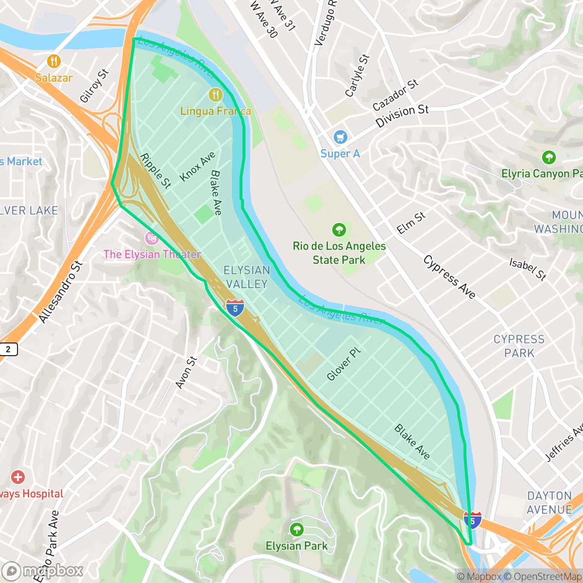
Elysian Valley, widely known as "Frogtown," is a geographically isolated Los Angeles neighborhood sandwiched between the Los Angeles River and the Golden State Freeway (I-5). Originally settled as "Gopher Flats" around 1900 for railroad workers, the area was initially dominated by Mexican, Japanese, and Chinese truck farms before being annexed in 1910 and subdivided for residential development in 1913. It earned its famous nickname in the mid-20th century when massive swarms of Western toads from the river regularly invaded its streets. The 1962 construction of the freeway physically cut off the neighborhood, preserving its distinct, low-density, small-town character. Today, Elysian Valley is a thriving creative hub defined by the Elysian Valley Bicycle & Pedestrian Path, the historic 1925 Dorris Place Elementary School, and the biennial Frogtown Art Walk.
The neighborhood functions as a quiet but active creative hub, anchored by local institutions like Spoke and the La Colombe Frogtown Cafe. The landscape is a blend of light industrial warehouses and residential blocks, creating a utilitarian yet artistic aesthetic. Access to the river path provides a rare recreational corridor, though the area remains physically constrained by the surrounding highway and railway infrastructure.
Living here involves distinct trade-offs, particularly regarding acoustic comfort. Due to its proximity to major transit arteries, the area experiences high noise levels. The housing stock is tightly packed with minimal setbacks, which reduces private outdoor space. However, it remains an attractive location for those who prioritize proximity to creative hubs and value the high health insurance coverage and strong local educational options like Dorris Place Elementary.
Neighborhood Scores Across 15 Qualities
Residential units are densely packed with minimal setbacks between structures. According to iHuus data, homes are positioned closer together here than is typical for the Los Angeles average.
Residential blocks feature a consistent street grid with sidewalks and safe crossings. However, pedestrian transit is significantly more difficult than the city average due to nearby industrial zones and high speed freeway interchanges.
Streetscapes range from standard high-density tract housing and industrial warehouses to modest residential lots with small yards. This visual variety is slightly below the Los Angeles average, according to iHuus data.
Access to open green space is inconsistent across the area; while the northern section offers large parklands and sports fields, other parts of the neighborhood are dominated by highway interchanges and private yards with limited public verges. According to iHuus data, the overall availability of dog-friendly public space is slightly above the city average.
Open land and scattered greenery provide a more rural atmosphere than much of Los Angeles. Residents will find a mix of low-density housing and pockets of woodland that feel less urbanized than the city average, according to iHuus data.
Low density and limited commercial activity result in a much quieter, more subdued atmosphere than the Los Angeles average. Most areas consist of light industrial or suburban landscapes with few social hubs or walkable retail options near major highways.
Frequent aircraft noise from nearby runways characterizes the area. According to iHuus data, acoustic comfort in this neighborhood is significantly lower than the Los Angeles average.
Air quality remains consistently high with rare instances of elevated readings. This area offers cleaner air than the Los Angeles average, according to iHuus data.
Industrial presence is minimal throughout most of the area, though some proximity to warehouses and transit corridors exists near the neighborhood boundaries. This level of commercial activity is lower than the Los Angeles average, according to iHuus data.
Health insurance access among residents is significantly higher than the Los Angeles average, according to iHuus data. Most individuals living in this area are covered by a health insurance plan.
Voting patterns and census indicators show a deeply liberal political leaning that is slightly more pronounced than the Los Angeles average, according to iHuus data.
Residents live alongside a balanced mix of young professionals, families, and seniors. According to iHuus data, this demographic distribution is slightly more varied than the typical Los Angeles profile.
Flood safety levels in this area are significantly higher than the Los Angeles average. While some residual risk exists within the 500-year floodplain, according to iHuus data, the neighborhood remains substantially more secure than much of the city.
Wildfire hazards are significantly higher than the Los Angeles average. Residents should prioritize enhanced fire mitigation strategies and remain vigilant during high-risk seasons according to iHuus data.
Address-Level Insights for Elysian Valley


iHuus Neighborhood Intelligence Insights
Get address-level neighborhood insights for Elysian Valley
- Street-level scores — see how individual blocks compare, not just neighborhood averages
- Micro-zone boundaries — identify quiet pockets, flood boundaries, and walkable clusters before you visit
- 15 dimensions in full — walkability, noise, air quality, school quality, insurance coverage, population age profile, urban/rural index, and more
- Boundary risk alerts — know if your address sits near a block boundary where scores drop, the kind of detail no listing will ever mention
- School insights — individual school ratings and insights, not just district-level data
- Compare before you commit — side-by-side data across neighborhoods, down to block precision
No credit card required
Compare with Any Neighborhood
| Dimension | Elysian Valley | Adams-Normandie |
|---|---|---|
| 🚶 Walkabilityavg 8.9 | ||
| 🔊 Acoustic Comfortavg 2.91 | ||
| 🤫 Privacy Indexavg 4.14 | ||
| 🎨 Visual Appealavg 6.58 | ||
| 🐕 Dog Friendlinessavg 5.04 | ||
| 🗺️ Urban-Rural Indexavg 5.96 | ||
| ✨ Neighborhood Vibeavg 5.07 | ||
| 🏥 Health Insurance Coverageavg 6.2 | ||
| 🌿 Air Qualityavg 8.12 | ||
| 🏭 Industrial Proximityavg 8.46 | ||
| 🌊 Flood Safetyavg 2.66 | ||
| 🗳️ Ideological Leanavg 9.56 | ||
| 👥 Population Age Profileavg 4.85 | ||
| 🔥 Fire Safetyavg 0.18 | ||
| 🏫 School Quality |
Elysian Valley Rankings
School Districts Serving Elysian Valley
School Insights for Elysian Valley
Below average outcomes; significant attendance and academic challenges.
School Insights
See what's really behind every school rating near Elysian Valley
- Individual school ratings — each school's own score with outcome context, not just a district average
- Enrollment & class size data — student-to-teacher ratio and how it compares to the state average
- Full demographics breakdown — ethnicity and gender composition for every school in the enrollment zone
- Every school in the district — all schools within the enrollment boundary ranked by rating, not just the closest one
- Grade levels & benchmarks — elementary through high school, with below/above state-average flags
No credit card required