City College Area, Long Beach
Updated June 22, 2026 · 12,239 residents
The City College Area is a quiet, highly walkable neighborhood defined by its mid-century suburban character and proximity to the Long Beach City College campus. Residents benefit from a robust sidewalk network and easy access to local green spaces, though the area experiences moderate noise levels primarily from surrounding road traffic.
Key Highlights
About City College Area
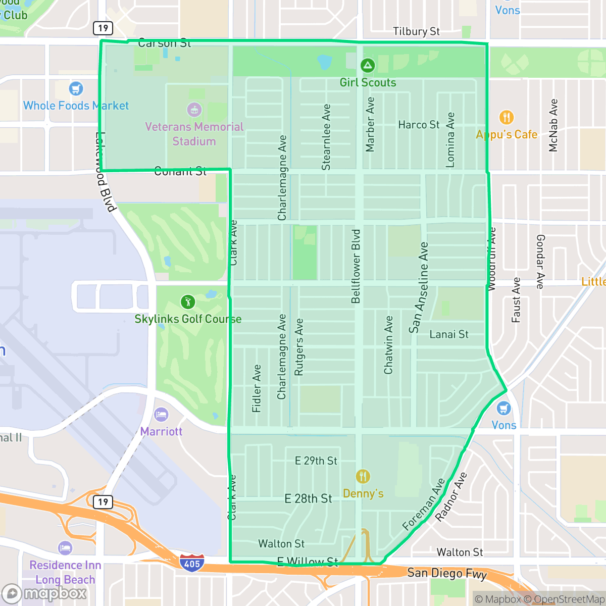
The City College Area, also known as South of Conant (or "SoCo") in East Long Beach, is a quiet, affluent residential neighborhood defined by its proximity to the Liberal Arts Campus of Long Beach City College (LBCC). While the college established its campus at Carson Street and Clark Avenue in 1935, the surrounding residential tract was developed primarily after World War II, during the late 1940s and 1950s. Originally built with modest two- and three-bedroom single-family homes, the neighborhood has evolved as many residences have been customized and expanded over the decades. Bordered by Conant Street, Spring Street, Clark Avenue, and Woodruff Avenue, the area is characterized by tree-lined streets and local landmarks, including Wardlow Park, the adjacent Skylinks Golf Course, and LBCC’s Veterans Memorial Stadium.
The City College Area functions as a dense suburban environment characterized by a consistent grid layout and well-maintained single-family homes. The neighborhood is notably pedestrian-friendly, with complete sidewalk coverage throughout its residential and arterial streets. The presence of Wardlow Park and proximity to educational institutions provide a steady, quiet atmosphere that supports a low-density residential lifestyle. While the area is primarily residential, residents have access to local dining and services that maintain a consistent rhythm of daily life within a purely residential and institutional land use setting.
This neighborhood is well-suited for families and individuals seeking a stable environment that is free from industrial activity. While it offers high health insurance coverage and a favorable profile regarding flood safety, prospective residents should consider the moderate acoustic environment caused by road traffic. It serves as an established community for those prioritizing walkability and proximity to public amenities over high-density commercial activity.
Neighborhood Scores Across 15 Qualities
Residential spacing varies between detached homes with private backyards and higher density layouts with shared fence lines. According to iHuus data, this level of separation is notably higher than the city average for Long Beach.
A complete sidewalk network with clearly marked crossings exists on both sides of most residential streets. According to iHuus data, pedestrian connectivity and access to local amenities are even more extensive here than in the rest of Long Beach.
Manicured properties and a high density of private backyard pools contribute to a visual landscape that is more polished than the Long Beach average. Many residences feature well-kept yards and mid-century architecture, according to iHuus data.
Large public parks and connected green corridors provide ample space and trails for pets. According to iHuus data, the availability of accessible walking areas in this area is significantly higher than the Long Beach average.
Residential life here follows a traditional suburban pattern featuring organized street grids and single-family homes. This layout offers a slightly more open feel than the more densely built sections of Long Beach.
Steady rhythms of local dining and services are interspersed with quiet, residential blocks and industrial corridors. This area offers a more subdued atmosphere than the Long Beach average, with many essential businesses being more accessible by car than on foot.
Frequent sounds from nearby freeway and railroad corridors characterize this area. According to iHuus data, acoustic disturbance levels are slightly higher than the Long Beach average.
Air quality in this area remains consistently good with rare instances of elevated readings. This level of air purity is slightly lower than the average found throughout Long Beach, according to iHuus data.
Industrial activity and warehouses are absent from this area, making it significantly more free of industrial hazards than the Long Beach average. Residents will find a landscape composed entirely of residential, institutional, and recreational land uses.
Health insurance accessibility is notably higher here than the Long Beach average, according to iHuus data. Most residents in the area have access to medical coverage.
Political leanings in this area are largely liberal, though the neighborhood is less overwhelmingly progressive than the broader Long Beach area according to iHuus data.
Residents live among a balanced mix of young adults, families, and older individuals, reflecting a demographic profile very similar to the rest of Long Beach.
Flood risk in this area is higher than the Long Beach average, though precise assessments are currently unavailable due to incomplete federal studies. Residents should remain aware of potential vulnerabilities during extreme weather events according to iHuus data.
Block-Level Insights for City College Area

iHuus Neighborhood Intelligence Insights
Get block-level neighborhood insights for City College Area
- Street-level scores — see how individual blocks compare, not just neighborhood averages
- Micro-zone boundaries — identify quiet pockets, flood boundaries, and walkable clusters before you visit
- 15 dimensions in full — walkability, noise, air quality, school quality, insurance coverage, population age profile, urban/rural index, and more
- Boundary risk alerts — know if your address sits near a block boundary where scores drop, the kind of detail no listing will ever mention
- School insights — individual school ratings and insights, not just district-level data
- Compare before you commit — side-by-side data across neighborhoods, down to block precision
No credit card required
Compare with Any Neighborhood
| Dimension | City College Area | Airport Area |
|---|---|---|
| 🚶 Walkabilityavg 9.37 | ||
| 🔊 Acoustic Comfortavg 3.04 | ||
| 🤫 Privacy Indexavg 3.63 | ||
| 🎨 Visual Appealavg 6.3 | ||
| 🐕 Dog Friendlinessavg 5.35 | ||
| 🗺️ Urban-Rural Indexavg 6 | ||
| ✨ Neighborhood Vibeavg 5.01 | ||
| 🏥 Health Insurance Coverageavg 6.4 | ||
| 🌿 Air Qualityavg 8.69 | ||
| 🏭 Industrial Proximityavg 8.14 | ||
| 🌊 Flood Safetyavg 3.75 | ||
| 🗳️ Ideological Leanavg 9.2 | ||
| 👥 Population Age Profileavg 4.81 | ||
| 🔥 Fire Safety | ||
| 🏫 School Quality |
City College Area Rankings
School Districts Serving City College Area
LBUSD is currently a district in transition, characterized by a 'Mixed/Transition' status where high academic accolades for its specialty programs and elite high schools are overshadowed by a severe $70 million budget deficit and declining enrollment. While the district maintains strong feeder patterns into prestigious pathways, the pending layoff of over 500 staff members, significant equity gaps across its 82 campuses, and the impending retirement of its Superintendent create a volatile operational environment. Community trust is currently strained by fiscal austerity measures and a lack of parity between neighborhood schools, though the district's core academic results remain stable and slightly improving.
Schools
School Insights for City College Area
Below average outcomes; significant attendance and academic challenges.
School Insights
See what's really behind every school rating near City College Area
- Individual school ratings — each school's own score with outcome context, not just a district average
- Enrollment & class size data — student-to-teacher ratio and how it compares to the state average
- Full demographics breakdown — ethnicity and gender composition for every school in the enrollment zone
- Every school in the district — all schools within the enrollment boundary ranked by rating, not just the closest one
- Grade levels & benchmarks — elementary through high school, with below/above state-average flags
No credit card required