South La Verne, La Verne
Updated June 22, 2026 · 2,560 residents
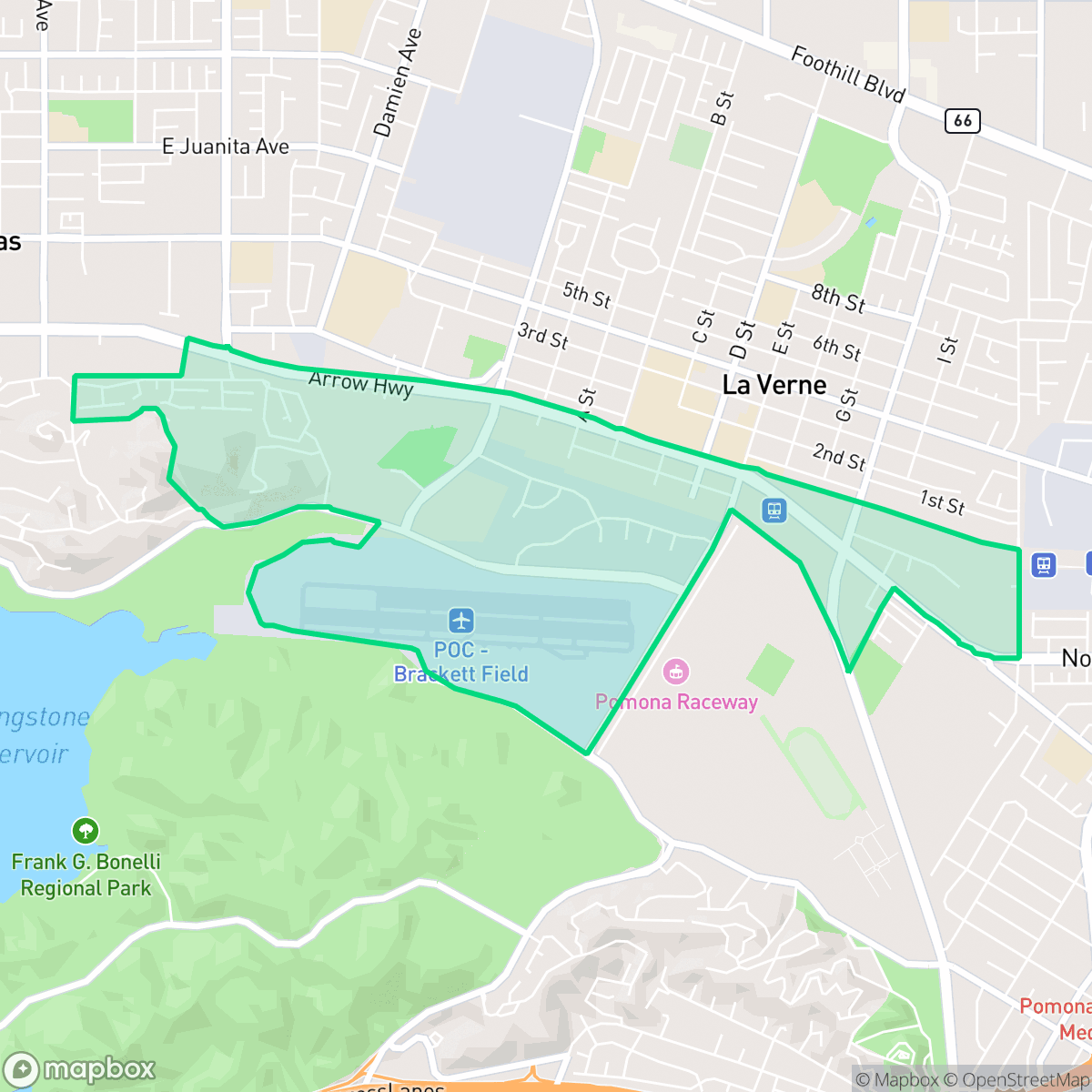
South La Verne is a distinct community defined by its industrial-rural landscape and proximity to the local airfield. While the area offers a quiet, car-oriented atmosphere with unique local dining, residents should be aware of the consistent road traffic noise and industrial surroundings.
Key Highlights
About South La Verne
Historically separated from the rest of the city by the Santa Fe railroad tracks, South La Verne emerged after 1910 as a distinct community settled primarily by Mexican immigrants who arrived to work in the region's booming citrus groves and packing houses. This geographic division fostered a de facto segregation, with the neighborhood developing a vibrant cultural identity as the "La Verne Barrio". To serve the local Spanish-speaking population, the city constructed the segregated Palomares School in 1927 at the corner of Arrow Highway and A Street, which operated until local schools integrated in 1947. The neighborhood was also anchored by the historic Our Lady of Guadalupe Catholic Church. Today, South La Verne retains a deep connection to its roots, defined by generations of families who built the foundation of the city's agricultural era.
The area is characterized by a blend of residential grids, commercial warehouses, and significant infrastructure, including the active runways of the local airfield. This layout creates a unique, low-density environment that stands in contrast to the more traditional suburban pockets of the city. Notable for its quiet, industrial-adjacent vibe, the neighborhood hosts local institutions like Norm's Hangar Coffee Shop and El Merendero, which serve as central gathering points for the community.
According to iHuus data, the neighborhood presents specific trade-offs for prospective residents, particularly regarding acoustic comfort due to road traffic and industrial activity. While it offers a more spacious feel compared to surrounding areas, the walkability is moderate and the environment is heavily car-dependent. It is best suited for those who prioritize proximity to regional transport links and a quieter, industrial-adjacent lifestyle over high-density walkability or central urban amenities.
Neighborhood Scores Across 15 Qualities
Residential structures feature mixed spacing with some shared fences and closely packed homes. This level of seclusion is slightly lower than the La Verne average, according to iHuus data.
Clear crosswalks and sidewalks on most streets provide reliable pedestrian infrastructure. While highly navigable, walkability is slightly lower than the La Verne average.
Residential views consist primarily of dense housing tracts and apartment complexes. According to iHuus data, the visual landscape is slightly less manicured than the average for La Verne.
Public parks with ball fields and wide sidewalk verges are available throughout residential blocks, though overall dog friendliness is slightly below the La Verne average according to iHuus data.
Residential areas blend with significant open spaces, including airport runways and golf courses. This landscape presents a slightly less developed character than the La Verne city average, featuring a combination of industrial warehouses and scattered single-family homes.
Low levels of social activity and nightlife define this area, which features a landscape of warehouses and light industrial units. According to iHuus data, the neighborhood is less vibrant than the La Verne average, functioning primarily as a car-oriented space for daily convenience and logistics.
Frequent noise from nearby railroad tracks and heavy freeway traffic persists throughout the area. This level of acoustic disturbance is higher than the average for La Verne, according to iHuus data.
Air quality is consistently high with minimal health concerns; this level of cleanliness is nearly on par with the average across La Verne.
Active airport runways and large logistics warehouses create notable noise and heavy truck traffic in certain parts of the neighborhood. This industrial density is higher than the average found throughout the rest of La Verne.
Health insurance enrollment among residents is lower than the average seen across the rest of La Verne, according to iHuus data.
Political leanings in this area tend toward the liberal side, representing a more progressive tilt than the La Verne city average according to iHuus data.
Residents experience a diverse age distribution ranging from young adults to seniors, though this demographic spread is slightly less varied than the city average according to iHuus data.
Significant flood risk exists here as portions of the area fall within the 100-year floodplain. This risk is notably higher than the average for La Verne, and residents should expect that flood insurance will likely be required for properties.
Block-Level Insights for South La Verne

iHuus Neighborhood Intelligence Insights
Get block-level neighborhood insights for South La Verne
- Street-level scores — see how individual blocks compare, not just neighborhood averages
- Micro-zone boundaries — identify quiet pockets, flood boundaries, and walkable clusters before you visit
- 15 dimensions in full — walkability, noise, air quality, school quality, insurance coverage, population age profile, urban/rural index, and more
- Boundary risk alerts — know if your address sits near a block boundary where scores drop, the kind of detail no listing will ever mention
- School insights — individual school ratings and insights, not just district-level data
- Compare before you commit — side-by-side data across neighborhoods, down to block precision
No credit card required
Compare with Any Neighborhood
| Dimension | South La Verne | Foothill Boulevard Corridor |
|---|---|---|
| 🚶 Walkabilityavg 8.19 | ||
| 🔊 Acoustic Comfortavg 2.95 | ||
| 🤫 Privacy Indexavg 5.37 | ||
| 🎨 Visual Appealavg 6.87 | ||
| 🐕 Dog Friendlinessavg 6.38 | ||
| 🗺️ Urban-Rural Indexavg 6.78 | ||
| ✨ Neighborhood Vibeavg 4.03 | ||
| 🏥 Health Insurance Coverageavg 7.95 | ||
| 🌿 Air Qualityavg 9.42 | ||
| 🏭 Industrial Proximityavg 7.94 | ||
| 🌊 Flood Safetyavg 2.78 | ||
| 🗳️ Ideological Leanavg 5.37 | ||
| 👥 Population Age Profileavg 5.28 | ||
| 🔥 Fire Safetyavg 0.34 | ||
| 🏫 School Quality |
South La Verne Rankings
School Districts Serving South La Verne
Bonita Unified School District is a high-performing 'Blue Chip' district characterized by a heavy concentration of top-rated elementary schools and prestigious high schools with high college-readiness metrics. The organization exhibits strong financial trust through successful community-supported bond measures for facility upgrades and maintains a stable leadership environment with long-tenured staff. Despite minor anecdotal social concerns and typical challenges facing alternative education sites, the district's consistent 'Green' dashboard indicators, state-level accolades, and robust extracurricular success in robotics and arts solidify its standing as a premier educational entity in the San Gabriel Valley.
Schools
Pomona Unified School District (PUSD) is currently a Tier 3 'Mixed' organization defined by sharp disparities in school-level performance and structural transitions. While it boasts high-performing gems like Diamond Ranch High and Pantera Elementary, a large portion of its campuses suffer from low proficiency scores and declining enrollment. The district is actively attempting to pivot through the expansion of 18 Career Technical Education (CTE) pathways and necessary school consolidations to manage fiscal constraints. Despite historical legal liabilities and safety concerns, the district maintains community trust through successful bond-funded facility improvements and a robust extracurricular culture, keeping it stable but preventing it from reaching a higher performance tier.
Schools
School Insights for South La Verne
Below average outcomes; significant attendance and academic challenges.
School Insights
See what's really behind every school rating near South La Verne
- Individual school ratings — each school's own score with outcome context, not just a district average
- Enrollment & class size data — student-to-teacher ratio and how it compares to the state average
- Full demographics breakdown — ethnicity and gender composition for every school in the enrollment zone
- Every school in the district — all schools within the enrollment boundary ranked by rating, not just the closest one
- Grade levels & benchmarks — elementary through high school, with below/above state-average flags
No credit card required