Upper B Street, Hayward
Updated June 22, 2026 · 4,669 residents
Upper B Street is a lively, highly walkable neighborhood in Hayward that blends historic residential charm with convenient access to local services. While the area offers excellent connectivity for pedestrians, residents should anticipate a dense living environment and notable noise levels from surrounding road traffic.
Key Highlights
About Upper B Street
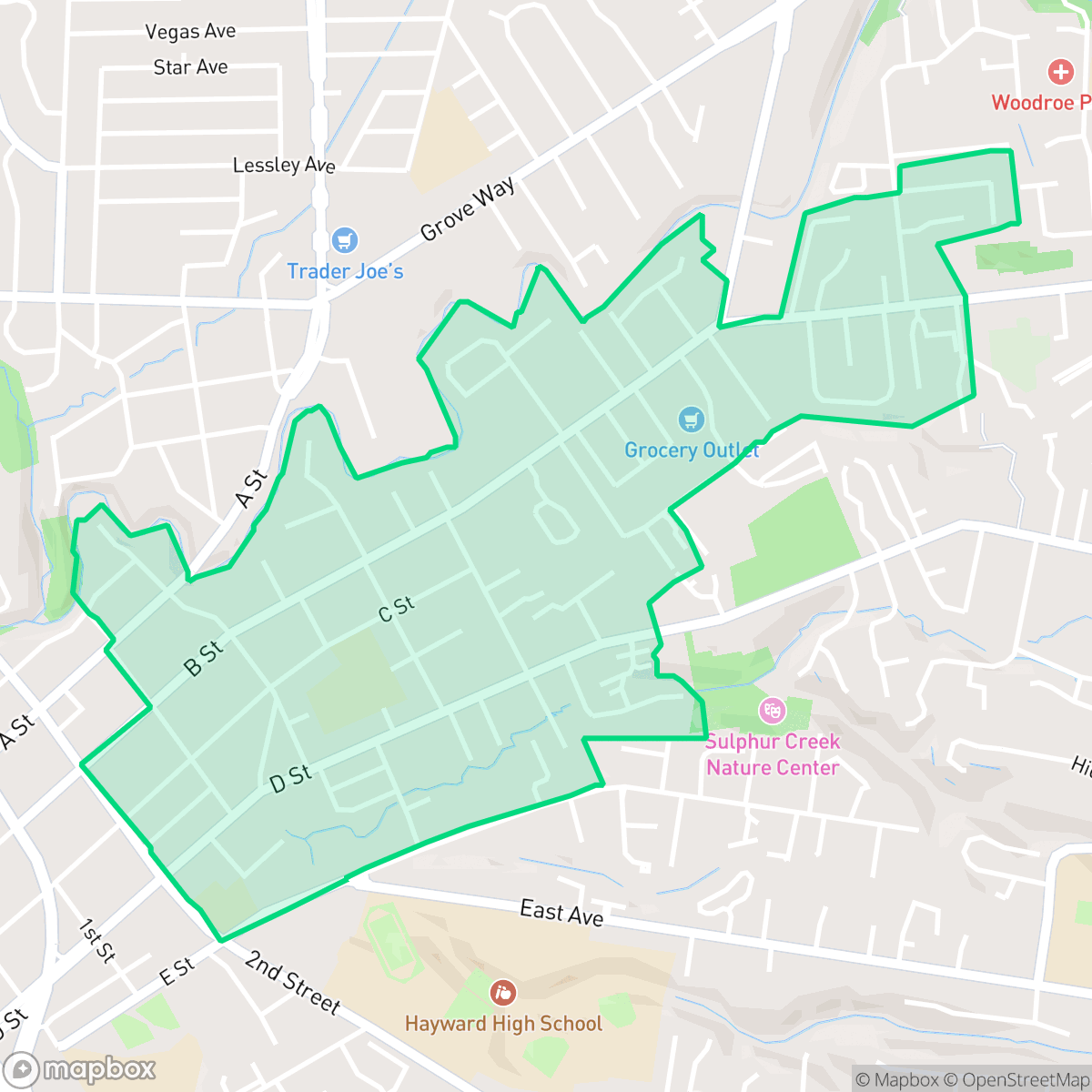
Bounded by Second Street, San Lorenzo Creek, and E Street, the Upper B Street neighborhood in Hayward, California, contains some of the city's earliest residential development. Historically, a horse-drawn streetcar line connected the neighborhood to downtown Hayward, traveling down the center of B Street from the local train station. Today, Upper B Street is characterized by its quiet, tree-lined boulevards featuring a mix of historic Victorian homes and charming mid-century bungalows. The neighborhood's western edge borders a proposed historic district aimed at preserving its architectural heritage. It is also situated near notable local landmarks, including the Hayward Japanese Gardens and the Sulphur Creek Nature Center.
The area functions as a dense, low-rise urban environment where residents benefit from high walkability and proximity to diverse amenities. The streetscape is characterized by a mix of single-family residences and small apartment buildings, fostering a social atmosphere that stands out within the city. Because the neighborhood is entirely residential and commercial, it avoids the presence of heavy industry or hazardous facilities, contributing to its status as a functional, accessible part of Hayward.
Prospective residents should weigh the benefits of its central location against specific trade-offs, including limited privacy due to closely spaced homes and higher ambient noise levels from local traffic. The local school district faces significant operational challenges, which may be a primary consideration for families. Given its high walkability and active social vibe, the neighborhood is well-suited for individuals who prioritize convenience and community engagement over seclusion or quiet surroundings.
Neighborhood Scores Across 15 Qualities
Residential spacing is somewhat varied, ranging from closely packed apartment blocks to single homes with moderate separation. This level of density is slightly higher than the Hayward average, meaning some neighbors live in close proximity with minimal buffers.
Sidewalks and clear pedestrian crossings are widely available throughout the residential grid, though large multi-lane arterials and nearby highway access can act as barriers to movement. This level of connectivity is roughly in line with the city average.
Residential views consist primarily of modest tract housing and apartment blocks with small yards and simple rooflines. This landscape is largely consistent with the broader Hayward area.
Accessible green spaces and connected sidewalk verges make pet walking convenient. According to iHuus data, this area offers more integrated park access than the Hayward average.
Residential pockets feature a blend of single-family homes and multi-unit complexes. This area presents a slightly more developed landscape than the city average, characterized by a mix of suburban housing and commercial strips.
Local dining and social hubs offer more activity than the typical Hayward neighborhood. While some blocks are quiet and car-dependent, other areas provide a diverse mix of amenities and green spaces.
Audible disturbances from nearby railroad tracks and major freeway corridors are common. According to iHuus data, acoustic comfort in this area is slightly below the Hayward average.
Air quality fluctuates between acceptable and unhealthy levels, presenting occasional concerns for sensitive groups. According to iHuus data, conditions in this area are roughly consistent with the Hayward city average.
Industrial activity is virtually absent here, with no warehouses, heavy industry, or hazardous facilities detected. According to iHuus data, this area is notably more free from industrial proximity than the Hayward average.
Health insurance coverage remains high among residents, though it sits slightly below the Hayward city average according to iHuus data.
Voting patterns and census indicators show a predominantly liberal political leaning that is consistent with the rest of Hayward. According to iHuus data, the ideological landscape here matches the city average.
Residents live alongside a balanced demographic of young adults, families, and older individuals. This age distribution is consistent with the broader Hayward area, according to iHuus data.
Located within a known floodplain, this area faces significant flood vulnerabilities that are more pronounced than the Hayward average. According to iHuus data, properties in this neighborhood are subject to higher risks of inundation and may require flood insurance.
Block-Level Insights for Upper B Street

iHuus Neighborhood Intelligence Insights
Get block-level neighborhood insights for Upper B Street
- Street-level scores — see how individual blocks compare, not just neighborhood averages
- Micro-zone boundaries — identify quiet pockets, flood boundaries, and walkable clusters before you visit
- 15 dimensions in full — walkability, noise, air quality, school quality, insurance coverage, population age profile, urban/rural index, and more
- Boundary risk alerts — know if your address sits near a block boundary where scores drop, the kind of detail no listing will ever mention
- School insights — individual school ratings and insights, not just district-level data
- Compare before you commit — side-by-side data across neighborhoods, down to block precision
No credit card required
Compare with Any Neighborhood
| Dimension | Upper B Street | Burbank |
|---|---|---|
| 🚶 Walkabilityavg 8.68 | ||
| 🔊 Acoustic Comfortavg 3.07 | ||
| 🤫 Privacy Indexavg 4.49 | ||
| 🎨 Visual Appealavg 6.11 | ||
| 🐕 Dog Friendlinessavg 6.49 | ||
| 🗺️ Urban-Rural Indexavg 6.69 | ||
| ✨ Neighborhood Vibeavg 4.15 | ||
| 🏥 Health Insurance Coverageavg 7.62 | ||
| 🌿 Air Qualityavg 5.88 | ||
| 🏭 Industrial Proximityavg 7.6 | ||
| 🌊 Flood Safetyavg 1.94 | ||
| 🗳️ Ideological Leanavg 9.75 | ||
| 👥 Population Age Profileavg 4.77 | ||
| 🔥 Fire Safetyavg 0.2 | ||
| 🏫 School Quality |
Upper B Street Rankings
School Districts Serving Upper B Street
Hayward Unified School District is currently in a distressed state, marked by a sharp academic divide and significant operational headwinds. While pockets of excellence exist in specialized programs like Dual Language Immersion and early literacy initiatives, nearly half of the district's schools are performing at the bottom tier of state metrics. The district faces a projected budget deficit driven by declining enrollment, leading to contentious 'School Transformation' plans that include potential closures and consolidations. Despite strong teacher commitment and improvements in school safety protocols, the combination of low-performing high schools, aging infrastructure, and fiscal instability prevents the district from achieving a stable middle-tier rating.
Schools
School Insights for Upper B Street
Below average outcomes; significant attendance and academic challenges.
School Insights
See what's really behind every school rating near Upper B Street
- Individual school ratings — each school's own score with outcome context, not just a district average
- Enrollment & class size data — student-to-teacher ratio and how it compares to the state average
- Full demographics breakdown — ethnicity and gender composition for every school in the enrollment zone
- Every school in the district — all schools within the enrollment boundary ranked by rating, not just the closest one
- Grade levels & benchmarks — elementary through high school, with below/above state-average flags
No credit card required