Verdugo Mountains, Glendale
Updated June 22, 2026 · 1,112 residents
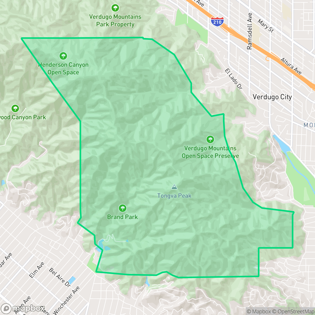
The Verdugo Mountains neighborhood offers a secluded, rural landscape within Glendale, characterized by vast open spaces and minimal development. It provides a quiet, serene environment that is exceptionally dog-friendly, though residents trade urban convenience and walkability for privacy and natural surroundings.
Key Highlights
About Verdugo Mountains
The Verdugo Mountains area serves as a rugged, tranquil escape from the dense urban sprawl of Los Angeles County. Defined by its expansive hillsides and proximity to natural landmarks like Brand Park, the neighborhood maintains a distinct rural character with very few local businesses or commercial hubs. The environment is notably quiet, with low noise levels and a high degree of privacy, making it an ideal setting for those seeking a retreat from the bustle of city life.
Living in this remote setting involves specific trade-offs, particularly regarding accessibility and infrastructure. While the area boasts high visual appeal and excellent conditions for dog owners, it lacks the walkability found in more central Glendale neighborhoods. Prospective residents should also be aware of the environmental context, as the region experiences significant fire safety risks compared to the rest of the city. It is best suited for individuals who prioritize peace, outdoor access, and a low-density residential lifestyle over immediate proximity to shopping or public transit.
Neighborhood Scores Across 15 Qualities
Large lot sizes and significant separation between properties provide a greater sense of seclusion than is typically found in Glendale. According to iHuus data, residents can expect much more distance from neighboring structures than the city average.
Pedestrian infrastructure is primarily limited to single-sided sidewalks and safe crossings. This level of walkability is notably lower than the Glendale city average.
Large residential properties and frequent upscale amenities create a high level of visual interest. This area features significantly more greenery and spacious landscaping than the Glendale average, according to iHuus data.
Access to large parks, hiking trails, and open spaces is significantly higher here than in the rest of Glendale. According to iHuus data, the area provides ample opportunities for pet owners to utilize expansive natural environments.
Open land and woodland areas characterize this area, offering a much more secluded atmosphere than the Glendale average. Scattered homes sit among natural terrain according to iHuus data.
Serene, low-density landscapes and vast open spaces dominate this area, which offers significantly less commercial activity and social density than the Glendale average. Most residents will find a quiet, rural environment that is primarily car-dependent due to the limited presence of local businesses and social hubs.
Steady sound from nearby busy streets creates a consistent level of ambient noise. This acoustic environment is notably more active than the average for Glendale, according to iHuus data.
Air quality is consistently good, matching the typical levels found throughout Glendale. According to iHuus data, residents can expect mostly clean air with only infrequent periods of elevated readings.
Zero industrial facilities, warehouses, or hazard sites are present within this area. According to iHuus data, this neighborhood offers a more secluded environment than the Glendale average due to its lack of commercial or industrial proximity.
Health insurance accessibility is quite high in this area, appearing roughly in line with the Glendale average according to iHuus data.
Political leanings in this area are largely liberal, though there is a more notable conservative presence than is found in the broader Glendale area. According to iHuus data, the community maintains a more balanced ideological landscape compared to the city average.
Residents live alongside a balanced mix of young professionals, families, and seniors. This demographic spread is slightly more varied than the typical age distribution found across Glendale, according to iHuus data.
Residual flood risks exist within some areas of the neighborhood due to its location in a 500-year floodplain. According to iHuus data, this level of safety is considerably higher than the Glendale average.
Wildfire danger is exceptionally high in this area, representing a significantly greater hazard than the Glendale average according to iHuus data. Residents must prioritize stringent fire prevention measures and emergency preparedness.
Block-Level Insights for Verdugo Mountains

iHuus Neighborhood Intelligence Insights
Get block-level neighborhood insights for Verdugo Mountains
- Street-level scores — see how individual blocks compare, not just neighborhood averages
- Micro-zone boundaries — identify quiet pockets, flood boundaries, and walkable clusters before you visit
- 15 dimensions in full — walkability, noise, air quality, school quality, insurance coverage, population age profile, urban/rural index, and more
- Boundary risk alerts — know if your address sits near a block boundary where scores drop, the kind of detail no listing will ever mention
- School insights — individual school ratings and insights, not just district-level data
- Compare before you commit — side-by-side data across neighborhoods, down to block precision
No credit card required
Compare with Any Neighborhood
| Dimension | Verdugo Mountains | Adams Hill |
|---|---|---|
| 🚶 Walkabilityavg 8.69 | ||
| 🔊 Acoustic Comfortavg 3.71 | ||
| 🤫 Privacy Indexavg 4.65 | ||
| 🎨 Visual Appealavg 6.99 | ||
| 🐕 Dog Friendlinessavg 5.3 | ||
| 🗺️ Urban-Rural Indexavg 6.32 | ||
| ✨ Neighborhood Vibeavg 5.1 | ||
| 🏥 Health Insurance Coverageavg 7.89 | ||
| 🌿 Air Qualityavg 8.01 | ||
| 🏭 Industrial Proximityavg 8.92 | ||
| 🌊 Flood Safetyavg 2.96 | ||
| 🗳️ Ideological Leanavg 8.52 | ||
| 👥 Population Age Profileavg 5.28 | ||
| 🔥 Fire Safetyavg 0.5 | ||
| 🏫 School Quality |
Verdugo Mountains Rankings
School Districts Serving Verdugo Mountains
Glendale Unified is a high-performing, stable district characterized by elite secondary schools and industry-leading specialized programs that drive strong college readiness. While it grapples with geographic disparities between the high-performing northern neighborhoods and lower-rated southern schools, its overall operational health remains solid with high graduation rates and a robust academic foundation. Despite navigating fiscal pressures from declining enrollment and aging facilities, GUSD's ability to retain families through unique language immersion and magnet offerings maintains its status as a premier Los Angeles-area educational provider.
Schools
Burbank Unified is currently in a state of 'Mixed/Transition' health. Academically, the district remains a top performer in California with elite graduation rates, prestigious awards for John Muir Middle, and nationally acclaimed arts programs at its terminal high schools. However, these successes are contrasted by a 2026 'Lack of Going Concern' fiscal designation from the county, triggered by leadership turnover and administrative investigations. While the district maintains strong community trust and high inter-district demand, the combination of administrative instability and significant performance disparities in its alternative education and middle school sectors prevents it from achieving a 'Solid' or 'Blue Chip' rating at this time.
Schools
School Insights for Verdugo Mountains
Below average outcomes; significant attendance and academic challenges.
School Insights
See what's really behind every school rating near Verdugo Mountains
- Individual school ratings — each school's own score with outcome context, not just a district average
- Enrollment & class size data — student-to-teacher ratio and how it compares to the state average
- Full demographics breakdown — ethnicity and gender composition for every school in the enrollment zone
- Every school in the district — all schools within the enrollment boundary ranked by rating, not just the closest one
- Grade levels & benchmarks — elementary through high school, with below/above state-average flags
No credit card required