Baylands, Fremont
Updated June 22, 2026 · 1,858 residents
Baylands is a coastal district in southwest Fremont defined by a blend of large-scale logistics centers, expansive retail hubs like Pacific Commons, and protected wetland preserves. While the area offers convenient access to major shopping and transit corridors, residents navigate a car-dependent environment with significant industrial activity and road traffic noise.
Key Highlights
About Baylands
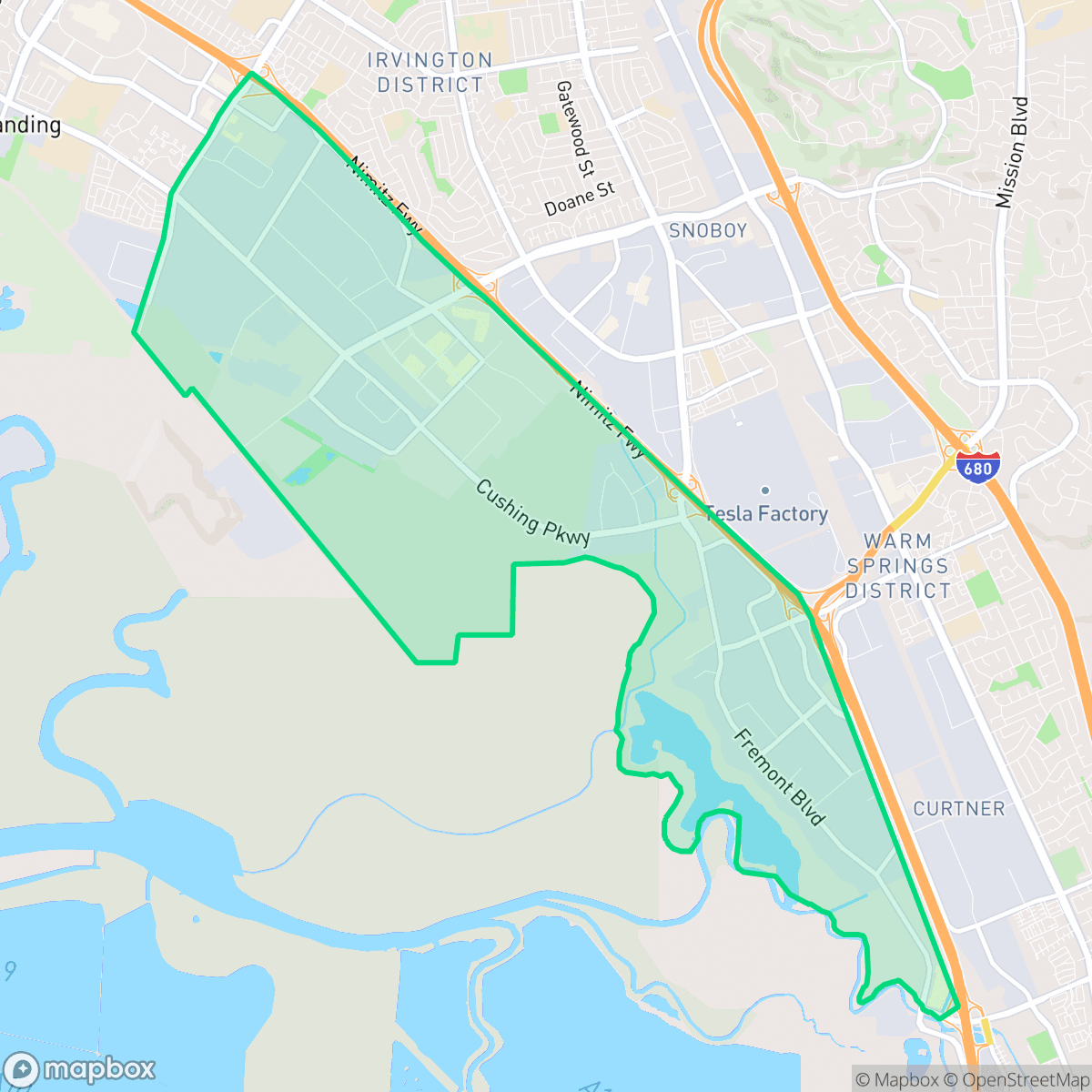
Situated along the southwest marshes of Fremont, California, the Baylands neighborhood has transitioned from indigenous Ohlone lands and 19th-century agricultural fields into a dynamic coastal hub. From 1959 to 1988, the area was home to the legendary Fremont Dragstrip (later Baylands Raceway Park), built on a former World War II auxiliary airfield. The track hosted iconic drag racers like Don Garlits and Shirley Muldowney before closing to make way for modern development. Today, the former raceway site is occupied by the sprawling Pacific Commons shopping and dining center. Modern Baylands features a mix of commercial spaces, contemporary residential townhomes built primarily after 2000, and preserved natural areas, including portions of the Don Edwards San Francisco Bay National Wildlife Refuge and the Coyote Creek Lagoon Trail.
The area serves as a primary logistics and commercial corridor for the region, characterized by massive warehouse facilities and high-traffic infrastructure. It provides a unique juxtaposition of heavy industrial activity and natural open space, with the Don Edwards San Francisco Bay National Wildlife Refuge offering a significant buffer against the dense commercial footprints. Residents primarily occupy modern townhome developments built after 2000, which are situated near major retail destinations that cater to essential daily needs.
Living in this neighborhood involves specific trade-offs, particularly regarding environmental and acoustic factors. According to iHuus data, the area experiences consistent noise from road traffic and frequent activity from semi-trucks associated with local logistics hubs. The environment is largely car-dependent, and prospective residents should be aware of the elevated risks related to flood and fire safety. It is best suited for individuals who prioritize proximity to regional transport routes and commercial amenities over quiet, suburban seclusion.
Neighborhood Scores Across 15 Qualities
Residential spacing is varied with some homes positioned closely to neighbors. This level of density is slightly higher than the Fremont average, according to iHuus data.
Dedicated pedestrian paths and a comprehensive sidewalk network connect residential areas to local schools and shops. While the area remains very accessible, walkability is slightly lower than the Fremont average.
Standard tract housing and apartment complexes feature consistent rooflines and modest yard sizes. According to iHuus data, the visual variety in this area is slightly lower than the Fremont average.
Access to large school fields and various parks offers plenty of walking paths for pets, though overall amenities for dogs are below the Fremont average according to iHuus data.
Vast expanses of open wetlands and salt ponds sit alongside dense industrial zones and large-scale warehouses. This landscape offers significant natural open space, though the area is slightly less rural than the Fremont average due to the prevalence of heavy commercial infrastructure.
Industrial warehouses, railway corridors, and highway proximity create a subdued atmosphere with limited social activity. According to iHuus data, this area is less lively than the Fremont average, as most amenities are car-dependent and scattered throughout a largely suburban and industrial landscape.
Frequent aircraft noise from the nearby airport runway and heavy rail proximity make this area significantly noisier than most of Fremont. According to iHuus data, acoustic comfort is minimal due to constant industrial and transit sounds.
Air quality levels are generally acceptable but include occasional days that may cause concern for sensitive groups. According to iHuus data, conditions in Baylands are slightly higher than the Fremont city average.
Large-scale logistics hubs and warehouse complexes with heavy truck traffic are much more prevalent here than in the rest of Fremont. Residents may experience increased noise and visual presence of semi-trucks and utility infrastructure near residential pockets.
Health insurance enrollment is very high among residents, matching the broader Fremont average according to iHuus data.
Voting patterns and census indicators show a predominantly liberal community, though this trend is slightly less pronounced than the Fremont city average.
Residents live alongside a balanced mix of young adults, families, and seniors. This demographic spread is largely consistent with the broader Fremont area, according to iHuus data.
Flood risk in this area is higher than the Fremont average due to undefined risk levels from recent assessments. According to iHuus data, FEMA has not yet finalized a detailed flood study for this specific location.
Block-Level Insights for Baylands

iHuus Neighborhood Intelligence Insights
Get block-level neighborhood insights for Baylands
- Street-level scores — see how individual blocks compare, not just neighborhood averages
- Micro-zone boundaries — identify quiet pockets, flood boundaries, and walkable clusters before you visit
- 15 dimensions in full — walkability, noise, air quality, school quality, insurance coverage, population age profile, urban/rural index, and more
- Boundary risk alerts — know if your address sits near a block boundary where scores drop, the kind of detail no listing will ever mention
- School insights — individual school ratings and insights, not just district-level data
- Compare before you commit — side-by-side data across neighborhoods, down to block precision
No credit card required
Compare with Any Neighborhood
| Dimension | Baylands | 28 Palms |
|---|---|---|
| 🚶 Walkabilityavg 9.3 | ||
| 🔊 Acoustic Comfortavg 3.38 | ||
| 🤫 Privacy Indexavg 5.09 | ||
| 🎨 Visual Appealavg 6.63 | ||
| 🐕 Dog Friendlinessavg 7.76 | ||
| 🗺️ Urban-Rural Indexavg 6.78 | ||
| ✨ Neighborhood Vibeavg 4.75 | ||
| 🏥 Health Insurance Coverageavg 8.99 | ||
| 🌿 Air Qualityavg 5.76 | ||
| 🏭 Industrial Proximityavg 8.97 | ||
| 🌊 Flood Safetyavg 3.62 | ||
| 🗳️ Ideological Leanavg 9.57 | ||
| 👥 Population Age Profileavg 4.91 | ||
| 🔥 Fire Safetyavg 0.2 | ||
| 🏫 School Quality |
Baylands Rankings
School Districts Serving Baylands
Fremont Unified School District is a high-performing academic powerhouse characterized by exceptional state testing scores, low chronic absenteeism, and a portfolio dominated by 10/10 rated schools. While the district maintains elite status in college readiness and teacher quality, it is currently navigating a significant $24.7 million budget reduction for the 2026-2027 cycle to ensure long-term solvency. Community sentiment reflects a high-pressure environment supported by strong parental involvement, and while facilities at some older campuses are maturing, the district remains a premier choice for families due to its consistent delivery of top-tier educational outcomes and stable institutional leadership.
Schools
Newark Unified School District is currently in a transitional state characterized by strong community identity and pockets of academic excellence, yet it is increasingly burdened by fiscal and structural instability. While primary feeders like Birch Grove are high-performing, the district faces a $4.5 million deficit, declining enrollment, and middle-to-high school ratings that hover around the state average. The district's 'B' grade from Niche and positive anecdotal feedback regarding safety and diversity are offset by significant turnover among young educators and persistent concerns regarding math and ELA proficiency. NUSD remains a stable community option but requires significant financial correction and facility modernization to move into a higher performance tier.
Schools
Santa Clara Unified School District is a high-performing academic entity currently navigating a period of significant fiscal instability. While the district boasts prestigious schools with ratings reaching 10/10 and showing year-over-year gains in state testing, it is grappling with a $30 million budget deficit and a projected enrollment decline. The unanimous board approval of over 100 staff layoffs in early 2026 highlights a necessary but painful 'rightsizing' phase. Despite these financial pressures, the district remains a destination for families due to its robust high school offerings and innovative teacher housing initiatives, though its long-term operational health depends on successfully stabilizing its budget and reserves.
Schools
School Insights for Baylands
Below average outcomes; significant attendance and academic challenges.
School Insights
See what's really behind every school rating near Baylands
- Individual school ratings — each school's own score with outcome context, not just a district average
- Enrollment & class size data — student-to-teacher ratio and how it compares to the state average
- Full demographics breakdown — ethnicity and gender composition for every school in the enrollment zone
- Every school in the district — all schools within the enrollment boundary ranked by rating, not just the closest one
- Grade levels & benchmarks — elementary through high school, with below/above state-average flags
No credit card required